Villaganzerla elevation
Villaganzerla (Veneto, Provincia di Vicenza), Italy elevation is 22 meters and Villaganzerla elevation in feet is 72 ft above sea level [src 1]. Villaganzerla is a populated place (feature code) with elevation that is 300 meters (984 ft) smaller than average city elevation in Italy.
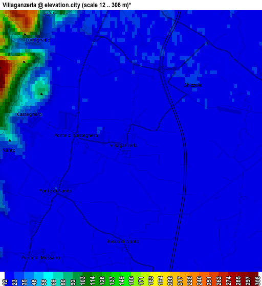
Below is the Elevation map of Villaganzerla, which displays elevation range with different colors. Scale of the first map is from 12 to 308 m (39 to 1010 ft) with average elevation of 27.2 meters (=89 ft) [note 1]
These maps also provides idea of topography and contour of this city, they are displayed at different zoom levels. More info about maps, scale and edge coordinates you can find below images.
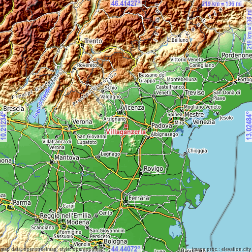
| \ | Map #1 | Topo.Map |
| Scale [m] | 12..308 m | × |
| Scale [ft] | 39..1010 ft | × |
| Average | 27.2 m = 89 ft | × |
| Width | 6.86 km = 4.3 mi | 219.4 km = 136.3 mi |
| Height | 6.86 km = 4.3 mi | 219.4 km = 136.3 mi |
| ↑Max Latitude | 45.466948° | 46.41427° |
| Latitude at center | 45.43612° | 45.43612° |
| ↓Min Latitude | 45.405275° | 44.44072° |
| ← Min Longitude | 11.574645° | 10.21234° |
| Longitude center | 11.61859° | 11.61859° |
| →Max Longitude | 11.662535° | 13.02484° |
Nearby cities:
Cities around Villaganzerla sort by population:
• Longare elevation 33 m
4.7 km,  348°
348°
• Ponte di Barbarano 18 m
5.8 km,  212°
212°
• Veggiano 19 m
7.5 km,  80°
80°
• Bastia 18 m
6.1 km,  154°
154°
• Barbarano Vicentino 46 m
6.6 km,  242°
242°
• Ponte di Nanto 22 m
2.3 km, 235°
• Montegalda 23 m
4.5 km, 75°
• Cervarese Santa Croce 19 m
5.6 km,  103°
103°
• Lumignano 31 m
3.6 km,  317°
317°
• Montegaldella 22 m
4 km,  88°
88°
• Ponte di Castegnero 21 m
1.4 km,  272°
272°
• Mossano 73 m
5.4 km,  249°
249°
Multilingual:
 En español:
Villaganzerla elevación 22 m.
 En France:
Villaganzerla élévation 22 m.
 Auf Deutsch:
Villaganzerla höhe über dem Meeresspiegel ist 22 m.

Sources and notes:
- [note 1] Map square and city borders are not equal. Map elevation data is calculated only from area inside that square.
- [src 1] Elevation data from geonames database provided with same terms of usage.
- [src 2] The elevation map of Villaganzerla is generated using elevation data from NASA's 3 arcsec (90m) resolution SRTM data.
- [src 3] Base (background) map © OpenStreetMap contributors tiles are generated by Geofabrik and OpenTopoMap.
Copyright & License:
This Villaganzerla Elevation Map is licensed under CC BY-SA. You may reuse any part from this page, if you give a proper credit by linking to this URL:
 More info on terms of use page.