Lancenigo-Villorba elevation
Lancenigo-Villorba (Veneto, Provincia di Treviso), Italy elevation is 24 meters and Lancenigo-Villorba elevation in feet is 79 ft above sea level [src 1]. Lancenigo-Villorba is a seat of a third-order administrative division (feature code) with elevation that is 298 meters (978 ft) smaller than average city elevation in Italy.
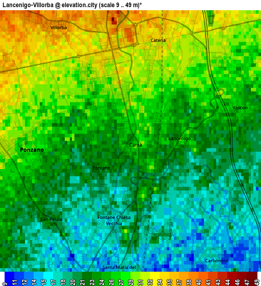
Below is the Elevation map of Lancenigo-Villorba, which displays elevation range with different colors. Scale of the first map is from 9 to 49 m (30 to 161 ft) with average elevation of 24.7 meters (=81 ft) [note 1]
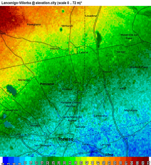
These maps also provides idea of topography and contour of this city, they are displayed at different zoom levels. More info about maps, scale and edge coordinates you can find below images.
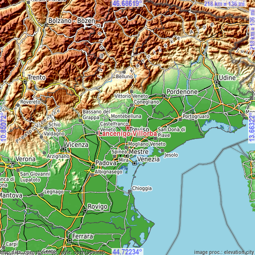
| \ | Map #1 | Map #2 | Topo.Map |
| Scale [m] | 9..49 m | 0..72 m | × |
| Scale [ft] | 30..161 ft | 0..236 ft | × |
| Average | 24.7 m = 81 ft | 27.4 m = 90 ft | × |
| Width | 6.82 km = 4.2 mi | 13.65 km = 8.5 mi | 218.4 km = 135.7 mi |
| Height | 6.82 km = 4.2 mi | 13.65 km = 8.5 mi | 218.3 km = 135.6 mi |
| ↑Max Latitude | 45.743567° | 45.774226° | 46.68619° |
| Latitude at center | 45.71289° | 45.71289° | 45.71289° |
| ↓Min Latitude | 45.682197° | 45.651486° | 44.72234° |
| ← Min Longitude | 12.213025° | 12.169079° | 10.85072° |
| Longitude center | 12.25697° | 12.25697° | 12.25697° |
| →Max Longitude | 12.300915° | 12.344861° | 13.66322° |
Nearby cities:
Cities around Lancenigo-Villorba sort by population:
• Treviso elevation 13 m
5.3 km,  193°
193°
• Ponzano 35 m
4.1 km,  273°
273°
• Carbonera 18 m
3.1 km,  139°
139°
• Maserada sul Piave 32 m
6.4 km,  47°
47°
• San Floriano-Olmi 11 m
7.2 km,  127°
127°
• Castagnole 29 m
6.4 km,  244°
244°
• Mignagola 16 m
5.7 km,  118°
118°
• Breda 21 m
5.8 km,  79°
79°
• Varago 29 m
5 km,  57°
57°
• Povegliano 54 m
6.4 km,  324°
324°
• Pero 17 m
7.2 km,  95°
95°
• Santandrà 46 m
5.8 km,  311°
311°
Multilingual:
 En español:
Lancenigo-Villorba elevación 24 m.
 En France:
Lancenigo-Villorba élévation 24 m.
 Auf Deutsch:
Lancenigo-Villorba höhe über dem Meeresspiegel ist 24 m.

Sources and notes:
- [note 1] Map square and city borders are not equal. Map elevation data is calculated only from area inside that square.
- [src 1] Elevation data from geonames database provided with same terms of usage.
- [src 2] The elevation map of Lancenigo-Villorba is generated using elevation data from NASA's 3 arcsec (90m) resolution SRTM data.
- [src 3] Base (background) map © OpenStreetMap contributors tiles are generated by Geofabrik and OpenTopoMap.
Copyright & License:
This Lancenigo-Villorba Elevation Map is licensed under CC BY-SA. You may reuse any part from this page, if you give a proper credit by linking to this URL:
 More info on terms of use page.