Zibello elevation
Zibello (Emilia-Romagna, Provincia di Parma), Italy elevation is 36 meters and Zibello elevation in feet is 118 ft above sea level [src 1]. Zibello is a seat of a third-order administrative division (feature code) with elevation that is 286 meters (938 ft) smaller than average city elevation in Italy.
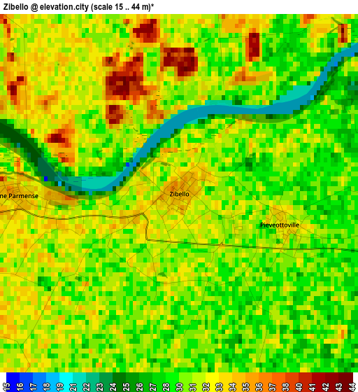
Below is the Elevation map of Zibello, which displays elevation range with different colors. Scale of the first map is from 15 to 44 m (49 to 144 ft) with average elevation of 30.6 meters (=100 ft) [note 1]
These maps also provides idea of topography and contour of this city, they are displayed at different zoom levels. More info about maps, scale and edge coordinates you can find below images.
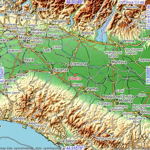
| \ | Map #1 | Topo.Map |
| Scale [m] | 15..44 m | × |
| Scale [ft] | 49..144 ft | × |
| Average | 30.6 m = 100 ft | × |
| Width | 6.91 km = 4.3 mi | 221.1 km = 137.4 mi |
| Height | 6.91 km = 4.3 mi | 221 km = 137.3 mi |
| ↑Max Latitude | 45.049526° | 46.00389° |
| Latitude at center | 45.01847° | 45.01847° |
| ↓Min Latitude | 44.987398° | 44.01579° |
| ← Min Longitude | 10.085735° | 8.72343° |
| Longitude center | 10.12968° | 10.12968° |
| →Max Longitude | 10.173625° | 11.53593° |
Nearby cities:
Cities around Zibello sort by population:
• Busseto elevation 43 m
8.1 km,  237°
237°
• Soragna 46 m
10.2 km,  184°
184°
• Sospiro 36 m
10.2 km,  12°
12°
• Roccabianca 34 m
7.1 km,  99°
99°
• San Daniele Po 32 m
6.5 km,  34°
34°
• Villanova 43 m
10.3 km,  274°
274°
• Stagno Lombardo 36 m
7 km,  332°
332°
• Pieve d'Olmi 35 m
7.9 km,  356°
356°
• Polesine Parmense 35 m
3.1 km, 266°
• Motta Baluffi 32 m
10.9 km,  67°
67°
• Cella Dati 34 m
11.2 km,  40°
40°
• Gerre de' Caprioli 38 m
10.1 km,  322°
322°
Multilingual:
 En español:
Zibello elevación 36 m.
 En France:
Zibello élévation 36 m.


Sources and notes:
- [note 1] Map square and city borders are not equal. Map elevation data is calculated only from area inside that square.
- [src 1] Elevation data from geonames database provided with same terms of usage.
- [src 2] The elevation map of Zibello is generated using elevation data from NASA's 3 arcsec (90m) resolution SRTM data.
- [src 3] Base (background) map © OpenStreetMap contributors tiles are generated by Geofabrik and OpenTopoMap.
Copyright & License:
This Zibello Elevation Map is licensed under CC BY-SA. You may reuse any part from this page, if you give a proper credit by linking to this URL:
 More info on terms of use page.