Bocchigliero elevation
Bocchigliero (Calabria, Provincia di Cosenza), Italy elevation is 879 meters and Bocchigliero elevation in feet is 2884 ft above sea level [src 1]. Bocchigliero is a seat of a third-order administrative division (feature code) with elevation that is 557 meters (1827 ft) bigger than average city elevation in Italy.
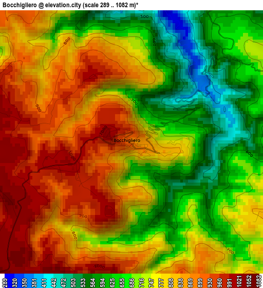
Below is the Elevation map of Bocchigliero, which displays elevation range with different colors. Scale of the first map is from 289 to 1082 m (948 to 3550 ft) with average elevation of 762.7 meters (=2502 ft) [note 1]
These maps also provides idea of topography and contour of this city, they are displayed at different zoom levels. More info about maps, scale and edge coordinates you can find below images.
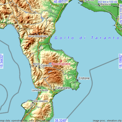
| \ | Map #1 | Topo.Map |
| Scale [m] | 289..1082 m | × |
| Scale [ft] | 948..3550 ft | × |
| Average | 762.7 m = 2502 ft | × |
| Width | 7.55 km = 4.7 mi | 241.6 km = 150.1 mi |
| Height | 7.55 km = 4.7 mi | 241.6 km = 150.1 mi |
| ↑Max Latitude | 39.45324° | 40.49717° |
| Latitude at center | 39.4193° | 39.4193° |
| ↓Min Latitude | 39.385343° | 38.3245° |
| ← Min Longitude | 16.706625° | 15.34432° |
| Longitude center | 16.75057° | 16.75057° |
| →Max Longitude | 16.794515° | 18.15682° |
Nearby cities:
Cities around Bocchigliero sort by population:
• Longobucco elevation 808 m
12.5 km,  285°
285°
• Mandatoriccio 552 m
8.9 km,  53°
53°
• Campana 620 m
6.2 km,  95°
95°
• Verzino 578 m
14.9 km,  142°
142°
• Savelli 984 m
12.1 km,  169°
169°
• Caloveto 368 m
9.7 km,  5°
5°
• Paludi 438 m
13.7 km,  333°
333°
• Cropalati 355 m
11 km,  349°
349°
• Scala Coeli 345 m
12.1 km,  74°
74°
• Caloppezzati 209 m
16.4 km,  15°
15°
• Umbriatico 406 m
16.1 km,  117°
117°
• Pietrapaola 385 m
9.4 km,  36°
36°
Multilingual:
 En español:
Bocchigliero elevación 879 m.
 En France:
Bocchigliero élévation 879 m.
 Auf Deutsch:
Bocchigliero höhe über dem Meeresspiegel ist 879 m.

Sources and notes:
- [note 1] Map square and city borders are not equal. Map elevation data is calculated only from area inside that square.
- [src 1] Elevation data from geonames database provided with same terms of usage.
- [src 2] The elevation map of Bocchigliero is generated using elevation data from NASA's 3 arcsec (90m) resolution SRTM data.
- [src 3] Base (background) map © OpenStreetMap contributors tiles are generated by Geofabrik and OpenTopoMap.
Copyright & License:
This Bocchigliero Elevation Map is licensed under CC BY-SA. You may reuse any part from this page, if you give a proper credit by linking to this URL:
 More info on terms of use page.