Capaci elevation
Capaci (Sicily, Palermo), Italy elevation is 52 meters and Capaci elevation in feet is 171 ft above sea level [src 1]. Capaci is a seat of a third-order administrative division (feature code) with elevation that is 270 meters (886 ft) smaller than average city elevation in Italy.
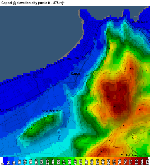
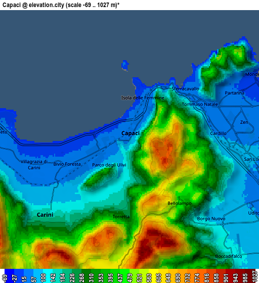
Below is the Elevation map of Capaci, which displays elevation range with different colors. Scale of the first map is from 0 to 878 m (0 to 2881 ft) with average elevation of 275.6 meters (=904 ft) [note 1]
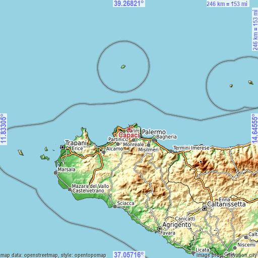
These maps also provides idea of topography and contour of this city, they are displayed at different zoom levels. More info about maps, scale and edge coordinates you can find below images.
| \ | Map #1 | Map #2 | Topo.Map |
| Scale [m] | 0..878 m | -69..1027 m | × |
| Scale [ft] | 0..2881 ft | -226..3369 ft | × |
| Average | 275.6 m = 904 ft | 279.4 m = 917 ft | × |
| Width | 7.68 km = 4.8 mi | 15.37 km = 9.6 mi | 245.8 km = 152.7 mi |
| Height | 7.68 km = 4.8 mi | 15.37 km = 9.6 mi | 245.8 km = 152.7 mi |
| ↑Max Latitude | 38.20561° | 38.240134° | 39.26821° |
| Latitude at center | 38.17107° | 38.17107° | 38.17107° |
| ↓Min Latitude | 38.136513° | 38.10194° | 37.05716° |
| ← Min Longitude | 13.195355° | 13.151409° | 11.83305° |
| Longitude center | 13.2393° | 13.2393° | 13.2393° |
| →Max Longitude | 13.283245° | 13.327191° | 14.64555° |
Nearby cities:
Cities around Capaci sort by population:
• Palermo elevation 46 m
9.5 km,  117°
117°
• Carini 173 m
6.6 km,  228°
228°
• Monreale 314 m
10.9 km,  156°
156°
• Cinisi 50 m
12.1 km,  264°
264°
• Sferracavallo 19 m
5 km,  50°
50°
• Isola delle Femmine 19 m
2.3 km,  16°
16°
• Montelepre 360 m
10.6 km,  211°
211°
• Pioppo 508 m
13.5 km,  182°
182°
• Piano dei Geli 397 m
8.6 km, 158°
• Torretta 273 m
4.5 km, 184°
• Giardinello 259 m
11.8 km,  217°
217°
• Cannizzaro-Favara 299 m
12.5 km,  166°
166°
Multilingual:
 En español:
Capaci elevación 52 m.
 En France:
Capaci élévation 52 m.


Sources and notes:
- [note 1] Map square and city borders are not equal. Map elevation data is calculated only from area inside that square.
- [src 1] Elevation data from geonames database provided with same terms of usage.
- [src 2] The elevation map of Capaci is generated using elevation data from NASA's 3 arcsec (90m) resolution SRTM data.
- [src 3] Base (background) map © OpenStreetMap contributors tiles are generated by Geofabrik and OpenTopoMap.
Copyright & License:
This Capaci Elevation Map is licensed under CC BY-SA. You may reuse any part from this page, if you give a proper credit by linking to this URL:
 More info on terms of use page.