Casteldaccia elevation
Casteldaccia (Sicily, Palermo), Italy elevation is 95 meters and Casteldaccia elevation in feet is 312 ft above sea level [src 1]. Casteldaccia is a seat of a third-order administrative division (feature code) with elevation that is 227 meters (745 ft) smaller than average city elevation in Italy.
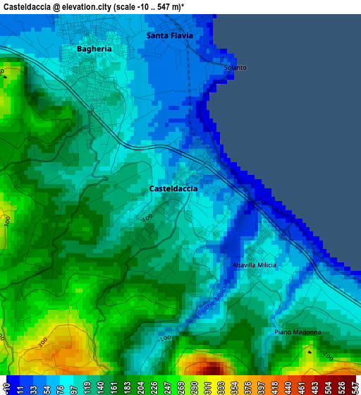
Below is the Elevation map of Casteldaccia, which displays elevation range with different colors. Scale of the first map is from -10 to 547 m (-33 to 1795 ft) with average elevation of 138.4 meters (=454 ft) [note 1]
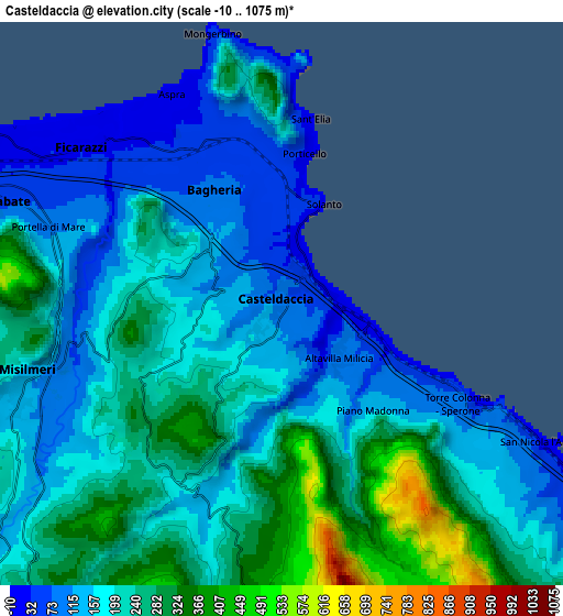
These maps also provides idea of topography and contour of this city, they are displayed at different zoom levels. More info about maps, scale and edge coordinates you can find below images.
| \ | Map #1 | Map #2 | Topo.Map |
| Scale [m] | -10..547 m | -10..1075 m | × |
| Scale [ft] | -33..1795 ft | -33..3527 ft | × |
| Average | 138.4 m = 454 ft | 203.5 m = 668 ft | × |
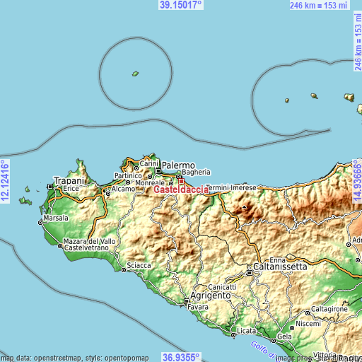
| Width | 7.7 km = 4.8 mi | 15.39 km = 9.6 mi | 246.2 km = 153 mi |
| Height | 7.7 km = 4.8 mi | 15.39 km = 9.6 mi | 246.2 km = 153 mi |
| ↑Max Latitude | 38.085807° | 38.120388° | 39.15017° |
| Latitude at center | 38.05121° | 38.05121° | 38.05121° |
| ↓Min Latitude | 38.016597° | 37.981967° | 36.9355° |
| ← Min Longitude | 13.486465° | 13.442519° | 12.12416° |
| Longitude center | 13.53041° | 13.53041° | 13.53041° |
| →Max Longitude | 13.574355° | 13.618301° | 14.93666° |
Nearby cities:
Cities around Casteldaccia sort by population:
• Bagheria elevation 80 m
3.5 km,  332°
332°
• Misilmeri 130 m
7.5 km,  253°
253°
• Villabate 56 m
8.2 km,  291°
291°
• Ficarazzi 17 m
7.4 km,  308°
308°
• Belmonte Mezzagno 349 m
12.1 km,  267°
267°
• Santa Flavia 26 m
5.9 km,  2°
2°
• Trabia 18 m
10.5 km,  119°
119°
• Ciaculli 54 m
11.1 km,  283°
283°
• Altavilla Milicia 93 m
2.2 km,  131°
131°
• Portella di Mare 81 m
6.5 km, 292°
• Bolognetta 300 m
11 km,  216°
216°
• Torre Colonna-Sperone 79 m
4.5 km, 122°
Multilingual:
 En español:
Casteldaccia elevación 95 m.
 En France:
Casteldaccia élévation 95 m.
 Auf Deutsch:
Casteldaccia höhe über dem Meeresspiegel ist 95 m.

Sources and notes:
- [note 1] Map square and city borders are not equal. Map elevation data is calculated only from area inside that square.
- [src 1] Elevation data from geonames database provided with same terms of usage.
- [src 2] The elevation map of Casteldaccia is generated using elevation data from NASA's 3 arcsec (90m) resolution SRTM data.
- [src 3] Base (background) map © OpenStreetMap contributors tiles are generated by Geofabrik and OpenTopoMap.
Copyright & License:
This Casteldaccia Elevation Map is licensed under CC BY-SA. You may reuse any part from this page, if you give a proper credit by linking to this URL:
 More info on terms of use page.