Godrano elevation
Godrano (Sicily, Palermo), Italy elevation is 710 meters and Godrano elevation in feet is 2329 ft above sea level [src 1]. Godrano is a seat of a third-order administrative division (feature code) with elevation that is 388 meters (1273 ft) bigger than average city elevation in Italy.
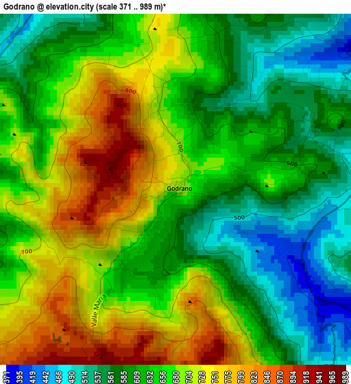
Below is the Elevation map of Godrano, which displays elevation range with different colors. Scale of the first map is from 371 to 989 m (1217 to 3245 ft) with average elevation of 651.3 meters (=2137 ft) [note 1]
These maps also provides idea of topography and contour of this city, they are displayed at different zoom levels. More info about maps, scale and edge coordinates you can find below images.
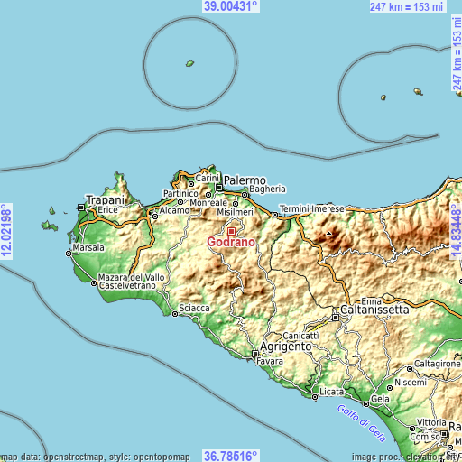
| \ | Map #1 | Topo.Map |
| Scale [m] | 371..989 m | × |
| Scale [ft] | 1217..3245 ft | × |
| Average | 651.3 m = 2137 ft | × |
| Width | 7.71 km = 4.8 mi | 246.7 km = 153.3 mi |
| Height | 7.71 km = 4.8 mi | 246.7 km = 153.3 mi |
| ↑Max Latitude | 37.937767° | 39.00431° |
| Latitude at center | 37.9031° | 37.9031° |
| ↓Min Latitude | 37.868417° | 36.78516° |
| ← Min Longitude | 13.384285° | 12.02198° |
| Longitude center | 13.42823° | 13.42823° |
| →Max Longitude | 13.472175° | 14.83448° |
Nearby cities:
Cities around Godrano sort by population:
• Misilmeri elevation 130 m
14.4 km,  6°
6°
• Corleone 558 m
14.9 km,  228°
228°
• Marineo 522 m
5.5 km,  350°
350°
• Ciminna 473 m
11.5 km,  93°
93°
• Villafrati 497 m
5 km, 85°
• Bolognetta 300 m
8 km,  17°
17°
• Mezzojuso 543 m
5.3 km,  142°
142°
• Ventimiglia di Sicilia 521 m
12.4 km,  79°
79°
• Baucina 559 m
9.8 km, 75°
• Cefalà Diana 575 m
3.4 km,  65°
65°
• Santa Cristina Gela 679 m
12.7 km,  315°
315°
• Campofelice di Fitalia 740 m
9.9 km,  149°
149°
Multilingual:
 En español:
Godrano elevación 710 m.
 En France:
Godrano élévation 710 m.


Sources and notes:
- [note 1] Map square and city borders are not equal. Map elevation data is calculated only from area inside that square.
- [src 1] Elevation data from geonames database provided with same terms of usage.
- [src 2] The elevation map of Godrano is generated using elevation data from NASA's 3 arcsec (90m) resolution SRTM data.
- [src 3] Base (background) map © OpenStreetMap contributors tiles are generated by Geofabrik and OpenTopoMap.
Copyright & License:
This Godrano Elevation Map is licensed under CC BY-SA. You may reuse any part from this page, if you give a proper credit by linking to this URL:
 More info on terms of use page.