Luzzi elevation
Luzzi (Calabria, Provincia di Cosenza), Italy elevation is 339 meters and Luzzi elevation in feet is 1112 ft above sea level [src 1]. Luzzi is a seat of a third-order administrative division (feature code) with elevation that is 17 meters (56 ft) bigger than average city elevation in Italy.
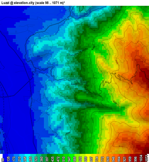
Below is the Elevation map of Luzzi, which displays elevation range with different colors. Scale of the first map is from 98 to 1071 m (322 to 3514 ft) with average elevation of 401.3 meters (=1317 ft) [note 1]
These maps also provides idea of topography and contour of this city, they are displayed at different zoom levels. More info about maps, scale and edge coordinates you can find below images.
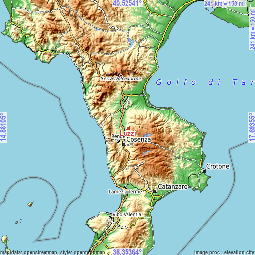
| \ | Map #1 | Topo.Map |
| Scale [m] | 98..1071 m | × |
| Scale [ft] | 322..3514 ft | × |
| Average | 401.3 m = 1317 ft | × |
| Width | 7.55 km = 4.7 mi | 241.5 km = 150.1 mi |
| Height | 7.55 km = 4.7 mi | 241.5 km = 150.1 mi |
| ↑Max Latitude | 39.481916° | 40.52541° |
| Latitude at center | 39.44799° | 39.44799° |
| ↓Min Latitude | 39.414047° | 38.35364° |
| ← Min Longitude | 16.243355° | 14.88105° |
| Longitude center | 16.2873° | 16.2873° |
| →Max Longitude | 16.331245° | 17.69355° |
Nearby cities:
Cities around Luzzi sort by population:
• Acri elevation 721 m
10.1 km,  57°
57°
• Bisignano 246 m
6.6 km,  355°
355°
• Taverna 143 m
5.2 km,  248°
248°
• Settimo 171 m
7.5 km,  212°
212°
• Arcavacata 307 m
12 km, 214°
• Stazione Montalto-Coretto 152 m
5.9 km,  219°
219°
• Sartano 257 m
11.7 km,  307°
307°
• Cavoni-Ginestreto 141 m
2.2 km,  282°
282°
• San Pietro in Guarano 661 m
12 km,  169°
169°
• Santa Sofia d'Epiro 558 m
11.4 km,  17°
17°
• Rose 444 m
5.4 km, 173°
• Castiglione Cosentino 384 m
10.6 km,  179°
179°
Multilingual:
 En español:
Luzzi elevación 339 m.
 En France:
Luzzi élévation 339 m.


Sources and notes:
- [note 1] Map square and city borders are not equal. Map elevation data is calculated only from area inside that square.
- [src 1] Elevation data from geonames database provided with same terms of usage.
- [src 2] The elevation map of Luzzi is generated using elevation data from NASA's 3 arcsec (90m) resolution SRTM data.
- [src 3] Base (background) map © OpenStreetMap contributors tiles are generated by Geofabrik and OpenTopoMap.
Copyright & License:
This Luzzi Elevation Map is licensed under CC BY-SA. You may reuse any part from this page, if you give a proper credit by linking to this URL:
 More info on terms of use page.