Magisano elevation
Magisano (Calabria, Provincia di Catanzaro), Italy elevation is 580 meters and Magisano elevation in feet is 1903 ft above sea level [src 1]. Magisano is a seat of a third-order administrative division (feature code) with elevation that is 258 meters (846 ft) bigger than average city elevation in Italy.
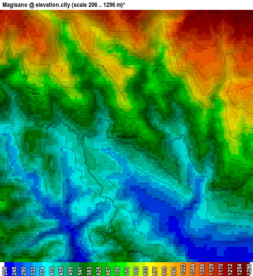
Below is the Elevation map of Magisano, which displays elevation range with different colors. Scale of the first map is from 206 to 1296 m (676 to 4252 ft) with average elevation of 619.2 meters (=2031 ft) [note 1]
These maps also provides idea of topography and contour of this city, they are displayed at different zoom levels. More info about maps, scale and edge coordinates you can find below images.
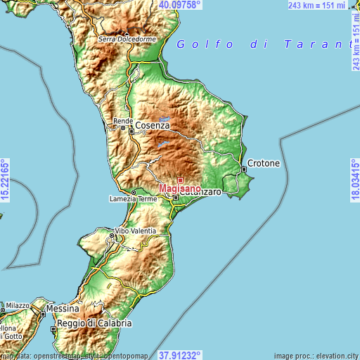
| \ | Map #1 | Topo.Map |
| Scale [m] | 206..1296 m | × |
| Scale [ft] | 676..4252 ft | × |
| Average | 619.2 m = 2031 ft | × |
| Width | 7.59 km = 4.7 mi | 243 km = 151 mi |
| Height | 7.59 km = 4.7 mi | 243 km = 151 mi |
| ↑Max Latitude | 39.047527° | 40.09758° |
| Latitude at center | 39.01339° | 39.01339° |
| ↓Min Latitude | 38.979236° | 37.91232° |
| ← Min Longitude | 16.583955° | 15.22165° |
| Longitude center | 16.6279° | 16.6279° |
| →Max Longitude | 16.671845° | 18.03415° |
Nearby cities:
Cities around Magisano sort by population:
• Sersale elevation 738 m
8.8 km,  92°
92°
• Gimigliano 530 m
9.4 km,  241°
241°
• Taverna 579 m
4.2 km,  283°
283°
• Crichi 423 m
6.8 km,  169°
169°
• Zagarise 578 m
3.5 km,  115°
115°
• Soveria Simeri 395 m
8.3 km,  148°
148°
• Sant'Elia 647 m
7.2 km,  210°
210°
• Pentone 644 m
5 km,  231°
231°
• Albi 710 m
2.9 km,  295°
295°
• Sorbo San Basile 613 m
5.1 km, 277°
• Sellia 492 m
3.5 km,  176°
176°
• Fossato Serralta 695 m
4.6 km,  245°
245°
Multilingual:
 En español:
Magisano elevación 580 m.
 En France:
Magisano élévation 580 m.
 Auf Deutsch:
Magisano höhe über dem Meeresspiegel ist 580 m.

Sources and notes:
- [note 1] Map square and city borders are not equal. Map elevation data is calculated only from area inside that square.
- [src 1] Elevation data from geonames database provided with same terms of usage.
- [src 2] The elevation map of Magisano is generated using elevation data from NASA's 3 arcsec (90m) resolution SRTM data.
- [src 3] Base (background) map © OpenStreetMap contributors tiles are generated by Geofabrik and OpenTopoMap.
Copyright & License:
This Magisano Elevation Map is licensed under CC BY-SA. You may reuse any part from this page, if you give a proper credit by linking to this URL:
 More info on terms of use page.