Maierà elevation
Maierà (Calabria, Provincia di Cosenza), Italy elevation is 329 meters and Maierà elevation in feet is 1079 ft above sea level [src 1]. Maierà is a seat of a third-order administrative division (feature code) with elevation that is 7 meters (23 ft) bigger than average city elevation in Italy.
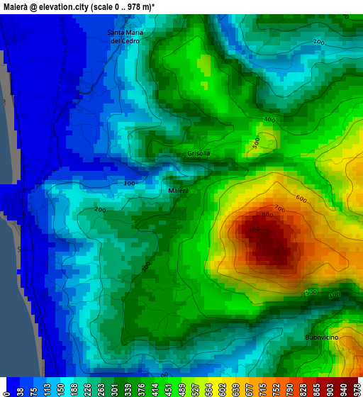
Below is the Elevation map of Maierà, which displays elevation range with different colors. Scale of the first map is from 0 to 978 m (0 to 3209 ft) with average elevation of 297.1 meters (=975 ft) [note 1]
These maps also provides idea of topography and contour of this city, they are displayed at different zoom levels. More info about maps, scale and edge coordinates you can find below images.
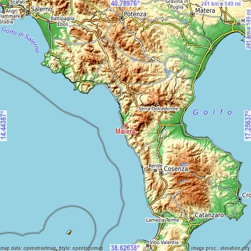
| \ | Map #1 | Topo.Map |
| Scale [m] | 0..978 m | × |
| Scale [ft] | 0..3209 ft | × |
| Average | 297.1 m = 975 ft | × |
| Width | 7.52 km = 4.7 mi | 240.5 km = 149.4 mi |
| Height | 7.52 km = 4.7 mi | 240.5 km = 149.4 mi |
| ↑Max Latitude | 39.750345° | 40.78976° |
| Latitude at center | 39.71655° | 39.71655° |
| ↓Min Latitude | 39.682738° | 38.62638° |
| ← Min Longitude | 15.806175° | 14.44387° |
| Longitude center | 15.85012° | 15.85012° |
| →Max Longitude | 15.894065° | 17.25637° |
Nearby cities:
Cities around Maierà sort by population:
• Scalea elevation 7 m
11 km,  335°
335°
• Belvedere Marittimo 198 m
10.9 km,  174°
174°
• Diamante 43 m
4.7 km,  211°
211°
• Verbicaro 478 m
6.9 km,  44°
44°
• Marcellina 33 m
5.9 km, 337°
• Santa Maria del Cedro 135 m
3.5 km, 340°
• San Nicola Arcella 125 m
15.1 km, 338°
• Grisolia 423 m
1.1 km,  27°
27°
• Santa Domenica Talao 220 m
11.4 km,  1°
1°
• Orsomarso 128 m
10.4 km, 28°
• Sangineto 280 m
13.5 km,  155°
155°
• Buonvicino 443 m
4.2 km,  136°
136°
Multilingual:
 En español:
Maierà elevación 329 m.
 En France:
Maierà élévation 329 m.


Sources and notes:
- [note 1] Map square and city borders are not equal. Map elevation data is calculated only from area inside that square.
- [src 1] Elevation data from geonames database provided with same terms of usage.
- [src 2] The elevation map of Maierà is generated using elevation data from NASA's 3 arcsec (90m) resolution SRTM data.
- [src 3] Base (background) map © OpenStreetMap contributors tiles are generated by Geofabrik and OpenTopoMap.
Copyright & License:
This Maierà Elevation Map is licensed under CC BY-SA. You may reuse any part from this page, if you give a proper credit by linking to this URL:
 More info on terms of use page.