Marinella elevation
Marinella (Sicily, Trapani), Italy elevation is 54 meters and Marinella elevation in feet is 177 ft above sea level [src 1]. Marinella is a populated place (feature code) with elevation that is 268 meters (879 ft) smaller than average city elevation in Italy.
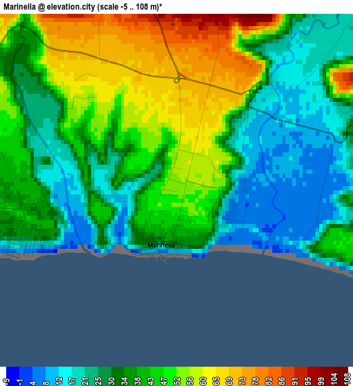
Below is the Elevation map of Marinella, which displays elevation range with different colors. Scale of the first map is from -5 to 108 m (-16 to 354 ft) with average elevation of 39 meters (=128 ft) [note 1]
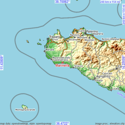
These maps also provides idea of topography and contour of this city, they are displayed at different zoom levels. More info about maps, scale and edge coordinates you can find below images.
| \ | Map #1 | Topo.Map |
| Scale [m] | -5..108 m | × |
| Scale [ft] | -16..354 ft | × |
| Average | 39 m = 128 ft | × |
| Width | 7.74 km = 4.8 mi | 247.8 km = 154 mi |
| Height | 7.74 km = 4.8 mi | 247.8 km = 154 mi |
| ↑Max Latitude | 37.629562° | 38.70062° |
| Latitude at center | 37.59475° | 37.59475° |
| ↓Min Latitude | 37.559922° | 36.4722° |
| ← Min Longitude | 12.800395° | 11.43809° |
| Longitude center | 12.84434° | 12.84434° |
| →Max Longitude | 12.888285° | 14.25059° |
Nearby cities:
Cities around Marinella sort by population:
• Mazara del Vallo elevation 17 m
23.4 km,  286°
286°
• Sciacca 69 m
23.3 km,  114°
114°
• Castelvetrano 196 m
10.6 km,  334°
334°
• Menfi 130 m
11 km,  84°
84°
• Partanna 409 m
15.2 km,  15°
15°
• Campobello di Mazara 109 m
9.5 km,  297°
297°
• Santa Margherita di Belice 411 m
18.6 km,  54°
54°
• Santa Ninfa 416 m
19.7 km,  8°
8°
• Montevago 389 m
17.3 km, 46°
• Salaparuta 180 m
23.2 km,  38°
38°
• Triscina 31 m
4.9 km,  260°
260°
• Tre Fontane 12 m
10.9 km, 255°
Multilingual:
 En español:
Marinella elevación 54 m.
 En France:
Marinella élévation 54 m.
 Auf Deutsch:
Marinella höhe über dem Meeresspiegel ist 54 m.

Sources and notes:
- [note 1] Map square and city borders are not equal. Map elevation data is calculated only from area inside that square.
- [src 1] Elevation data from geonames database provided with same terms of usage.
- [src 2] The elevation map of Marinella is generated using elevation data from NASA's 3 arcsec (90m) resolution SRTM data.
- [src 3] Base (background) map © OpenStreetMap contributors tiles are generated by Geofabrik and OpenTopoMap.
Copyright & License:
This Marinella Elevation Map is licensed under CC BY-SA. You may reuse any part from this page, if you give a proper credit by linking to this URL:
 More info on terms of use page.