Martone elevation
Martone (Calabria, Provincia di Reggio Calabria), Italy elevation is 313 meters and Martone elevation in feet is 1027 ft above sea level [src 1]. Martone is a seat of a third-order administrative division (feature code) with elevation that is 9 meters (30 ft) smaller than average city elevation in Italy.
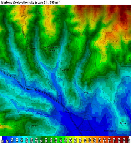
Below is the Elevation map of Martone, which displays elevation range with different colors. Scale of the first map is from 51 to 895 m (167 to 2936 ft) with average elevation of 309.2 meters (=1014 ft) [note 1]
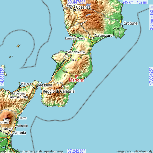
These maps also provides idea of topography and contour of this city, they are displayed at different zoom levels. More info about maps, scale and edge coordinates you can find below images.
| \ | Map #1 | Topo.Map |
| Scale [m] | 51..895 m | × |
| Scale [ft] | 167..2936 ft | × |
| Average | 309.2 m = 1014 ft | × |
| Width | 7.66 km = 4.8 mi | 245.2 km = 152.4 mi |
| Height | 7.66 km = 4.8 mi | 245.2 km = 152.4 mi |
| ↑Max Latitude | 38.387984° | 39.44789° |
| Latitude at center | 38.35353° | 38.35353° |
| ↓Min Latitude | 38.31906° | 37.24238° |
| ← Min Longitude | 16.244055° | 14.88175° |
| Longitude center | 16.288° | 16.288° |
| →Max Longitude | 16.331945° | 17.69425° |
Nearby cities:
Cities around Martone sort by population:
• Siderno elevation 15 m
9.3 km,  175°
175°
• Locri 16 m
13 km,  190°
190°
• Roccella Ionica 16 m
10.2 km,  110°
110°
• Gioiosa Ionica 85 m
3.2 km,  154°
154°
• Marina di Gioiosa Ionica 13 m
6.9 km, 146°
• Mammola 224 m
4.4 km,  283°
283°
• Caulonia 260 m
11 km,  73°
73°
• Gerace 413 m
10.9 km,  212°
212°
• Agnana Calabra 195 m
7.8 km,  222°
222°
• San Giovanni di Gerace 326 m
1.6 km,  325°
325°
• Grotteria 342 m
2.4 km,  302°
302°
• Canolo 395 m
8.8 km,  240°
240°
Multilingual:
 En español:
Martone elevación 313 m.
 En France:
Martone élévation 313 m.


Sources and notes:
- [note 1] Map square and city borders are not equal. Map elevation data is calculated only from area inside that square.
- [src 1] Elevation data from geonames database provided with same terms of usage.
- [src 2] The elevation map of Martone is generated using elevation data from NASA's 3 arcsec (90m) resolution SRTM data.
- [src 3] Base (background) map © OpenStreetMap contributors tiles are generated by Geofabrik and OpenTopoMap.
Copyright & License:
This Martone Elevation Map is licensed under CC BY-SA. You may reuse any part from this page, if you give a proper credit by linking to this URL:
 More info on terms of use page.