Mesoraca elevation
Mesoraca (Calabria, Provincia di Crotone), Italy elevation is 427 meters and Mesoraca elevation in feet is 1401 ft above sea level [src 1]. Mesoraca is a seat of a third-order administrative division (feature code) with elevation that is 105 meters (344 ft) bigger than average city elevation in Italy.
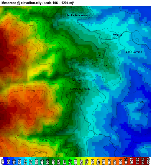
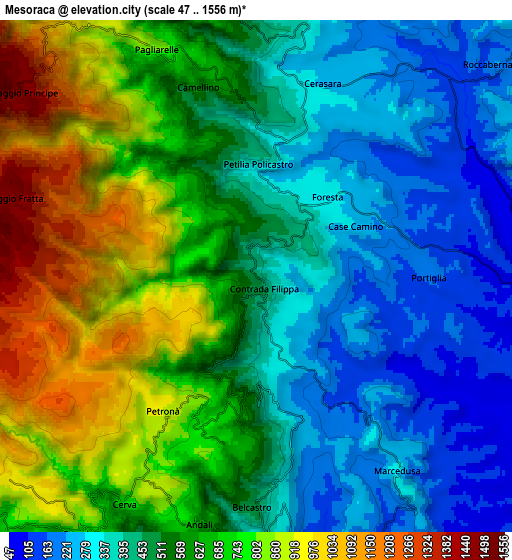
Below is the Elevation map of Mesoraca, which displays elevation range with different colors. Scale of the first map is from 106 to 1204 m (348 to 3950 ft) with average elevation of 505.8 meters (=1659 ft) [note 1]
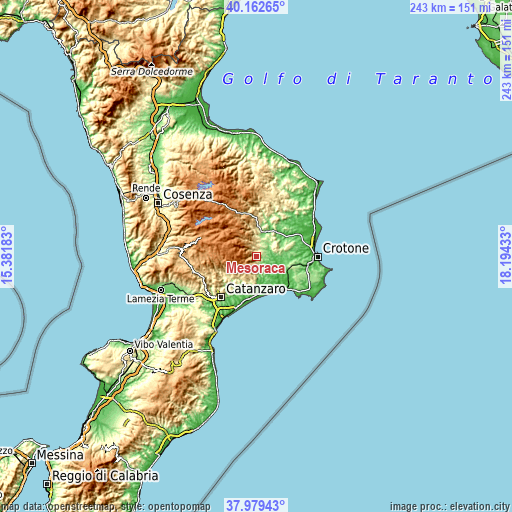
These maps also provides idea of topography and contour of this city, they are displayed at different zoom levels. More info about maps, scale and edge coordinates you can find below images.
| \ | Map #1 | Map #2 | Topo.Map |
| Scale [m] | 106..1204 m | 47..1556 m | × |
| Scale [ft] | 348..3950 ft | 154..5105 ft | × |
| Average | 505.8 m = 1659 ft | 560.9 m = 1840 ft | × |
| Width | 7.59 km = 4.7 mi | 15.17 km = 9.4 mi | 242.8 km = 150.9 mi |
| Height | 7.59 km = 4.7 mi | 15.17 km = 9.4 mi | 242.7 km = 150.8 mi |
| ↑Max Latitude | 39.113585° | 39.147674° | 40.16265° |
| Latitude at center | 39.07948° | 39.07948° | 39.07948° |
| ↓Min Latitude | 39.045358° | 39.01122° | 37.97943° |
| ← Min Longitude | 16.744135° | 16.700189° | 15.38183° |
| Longitude center | 16.78808° | 16.78808° | 16.78808° |
| →Max Longitude | 16.832025° | 16.875971° | 18.19433° |
Nearby cities:
Cities around Mesoraca sort by population:
• Petilia Policastro elevation 493 m
3.8 km,  351°
351°
• Cotronei 558 m
8.9 km, 353°
• Sersale 738 m
9.2 km,  213°
213°
• Roccabernarda 147 m
8.6 km,  46°
46°
• Petronà 897 m
4.8 km, 213°
• San Mauro Marchesato 272 m
12.2 km,  76°
76°
• Pagliarelle 834 m
7.5 km,  334°
334°
• Cerva 842 m
7.2 km, 210°
• Foresta 299 m
3.1 km,  44°
44°
• Belcastro 465 m
6.8 km,  181°
181°
• Andali 623 m
7.6 km,  192°
192°
• Marcedusa 297 m
7.2 km,  144°
144°
Multilingual:
 En español:
Mesoraca elevación 427 m.
 En France:
Mesoraca élévation 427 m.
 Auf Deutsch:
Mesoraca höhe über dem Meeresspiegel ist 427 m.

Sources and notes:
- [note 1] Map square and city borders are not equal. Map elevation data is calculated only from area inside that square.
- [src 1] Elevation data from geonames database provided with same terms of usage.
- [src 2] The elevation map of Mesoraca is generated using elevation data from NASA's 3 arcsec (90m) resolution SRTM data.
- [src 3] Base (background) map © OpenStreetMap contributors tiles are generated by Geofabrik and OpenTopoMap.
Copyright & License:
This Mesoraca Elevation Map is licensed under CC BY-SA. You may reuse any part from this page, if you give a proper credit by linking to this URL:
 More info on terms of use page.