Nicotera elevation
Nicotera (Calabria, Provincia di Vibo-Valentia), Italy elevation is 78 meters and Nicotera elevation in feet is 256 ft above sea level [src 1]. Nicotera is a seat of a third-order administrative division (feature code) with elevation that is 244 meters (801 ft) smaller than average city elevation in Italy.
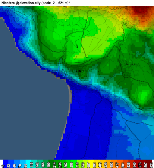
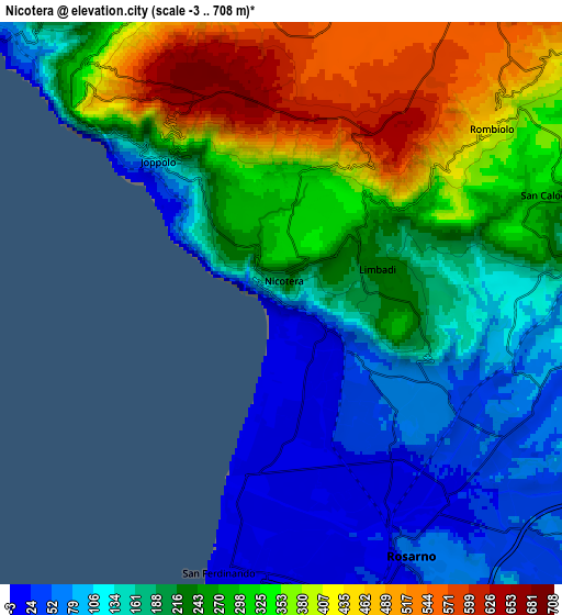
Below is the Elevation map of Nicotera, which displays elevation range with different colors. Scale of the first map is from -2 to 621 m (-7 to 2037 ft) with average elevation of 167.8 meters (=551 ft) [note 1]
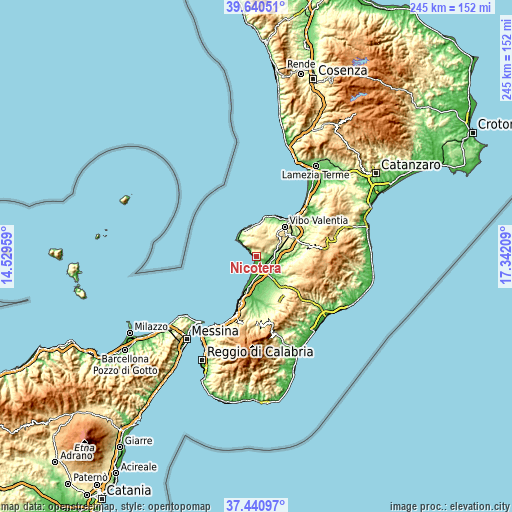
These maps also provides idea of topography and contour of this city, they are displayed at different zoom levels. More info about maps, scale and edge coordinates you can find below images.
| \ | Map #1 | Map #2 | Topo.Map |
| Scale [m] | -2..621 m | -3..708 m | × |
| Scale [ft] | -7..2037 ft | -10..2323 ft | × |
| Average | 167.8 m = 551 ft | 241.5 m = 792 ft | × |
| Width | 7.64 km = 4.7 mi | 15.29 km = 9.5 mi | 244.6 km = 152 mi |
| Height | 7.64 km = 4.7 mi | 15.29 km = 9.5 mi | 244.6 km = 152 mi |
| ↑Max Latitude | 38.58351° | 38.617854° | 39.64051° |
| Latitude at center | 38.54915° | 38.54915° | 38.54915° |
| ↓Min Latitude | 38.514773° | 38.48038° | 37.44097° |
| ← Min Longitude | 15.891895° | 15.847949° | 14.52959° |
| Longitude center | 15.93584° | 15.93584° | 15.93584° |
| →Max Longitude | 15.979785° | 16.023731° | 17.34209° |
Nearby cities:
Cities around Nicotera sort by population:
• Rosarno elevation 67 m
7.9 km,  151°
151°
• San Ferdinando 8 m
7.4 km,  191°
191°
• San Calogero 281 m
7.8 km,  68°
68°
• Limbadi-Caroni 233 m
2.7 km, 66°
• Rombiolo 465 m
7.7 km,  48°
48°
• Paravati 302 m
11.6 km, 66°
• Pernocari-Presinaci 551 m
9.2 km,  40°
40°
• Spilinga 438 m
9.2 km,  343°
343°
• San Nicolò 139 m
12 km,  322°
322°
• Joppolo 131 m
5.1 km, 318°
• Ricadi 286 m
10.4 km, 324°
• Filandari 485 m
11.1 km, 48°
Multilingual:
 En español:
Nicotera elevación 78 m.
 En France:
Nicotera élévation 78 m.


Sources and notes:
- [note 1] Map square and city borders are not equal. Map elevation data is calculated only from area inside that square.
- [src 1] Elevation data from geonames database provided with same terms of usage.
- [src 2] The elevation map of Nicotera is generated using elevation data from NASA's 3 arcsec (90m) resolution SRTM data.
- [src 3] Base (background) map © OpenStreetMap contributors tiles are generated by Geofabrik and OpenTopoMap.
Copyright & License:
This Nicotera Elevation Map is licensed under CC BY-SA. You may reuse any part from this page, if you give a proper credit by linking to this URL:
 More info on terms of use page.