Parghelia elevation
Parghelia (Calabria, Provincia di Vibo-Valentia), Italy elevation is 80 meters and Parghelia elevation in feet is 262 ft above sea level [src 1]. Parghelia is a seat of a third-order administrative division (feature code) with elevation that is 242 meters (794 ft) smaller than average city elevation in Italy.
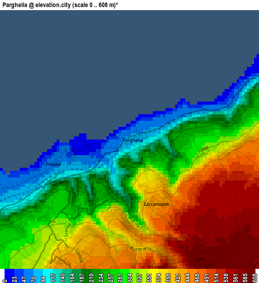
Below is the Elevation map of Parghelia, which displays elevation range with different colors. Scale of the first map is from 0 to 608 m (0 to 1995 ft) with average elevation of 322.2 meters (=1057 ft) [note 1]
These maps also provides idea of topography and contour of this city, they are displayed at different zoom levels. More info about maps, scale and edge coordinates you can find below images.
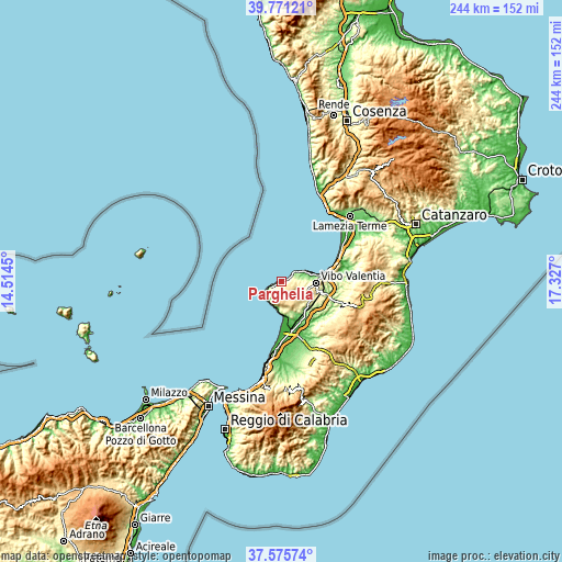
| \ | Map #1 | Topo.Map |
| Scale [m] | 0..608 m | × |
| Scale [ft] | 0..1995 ft | × |
| Average | 322.2 m = 1057 ft | × |
| Width | 7.63 km = 4.7 mi | 244.1 km = 151.7 mi |
| Height | 7.63 km = 4.7 mi | 244.1 km = 151.7 mi |
| ↑Max Latitude | 38.716187° | 39.77121° |
| Latitude at center | 38.68189° | 38.68189° |
| ↓Min Latitude | 38.647577° | 37.57574° |
| ← Min Longitude | 15.876805° | 14.5145° |
| Longitude center | 15.92075° | 15.92075° |
| →Max Longitude | 15.964695° | 17.327° |
Nearby cities:
Cities around Parghelia sort by population:
• Tropea elevation 67 m
2.4 km,  249°
249°
• Briatico 75 m
10.3 km,  63°
63°
• Zungri 543 m
6.2 km,  117°
117°
• Pernocari-Presinaci 551 m
10.7 km,  136°
136°
• Santa Domenica 84 m
5.5 km, 246°
• Spilinga 438 m
6.1 km,  192°
192°
• San Nicolò 139 m
8 km,  228°
228°
• Zaccanopoli 428 m
2 km,  159°
159°
• Cessaniti 421 m
9.7 km,  101°
101°
• Ricadi 286 m
7.9 km,  216°
216°
• Zambrone 224 m
6.3 km,  72°
72°
• Drapia 257 m
1.9 km,  205°
205°
Multilingual:
 En español:
Parghelia elevación 80 m.
 En France:
Parghelia élévation 80 m.
 Auf Deutsch:
Parghelia höhe über dem Meeresspiegel ist 80 m.

Sources and notes:
- [note 1] Map square and city borders are not equal. Map elevation data is calculated only from area inside that square.
- [src 1] Elevation data from geonames database provided with same terms of usage.
- [src 2] The elevation map of Parghelia is generated using elevation data from NASA's 3 arcsec (90m) resolution SRTM data.
- [src 3] Base (background) map © OpenStreetMap contributors tiles are generated by Geofabrik and OpenTopoMap.
Copyright & License:
This Parghelia Elevation Map is licensed under CC BY-SA. You may reuse any part from this page, if you give a proper credit by linking to this URL:
 More info on terms of use page.