Priolo Gargallo elevation
Priolo Gargallo (Sicily, Provincia di Siracusa), Italy elevation is 38 meters and Priolo Gargallo elevation in feet is 125 ft above sea level [src 1]. Priolo Gargallo is a seat of a third-order administrative division (feature code) with elevation that is 284 meters (932 ft) smaller than average city elevation in Italy.
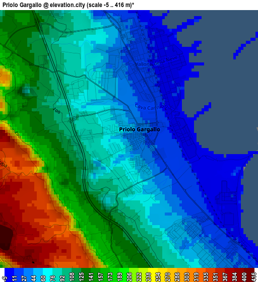
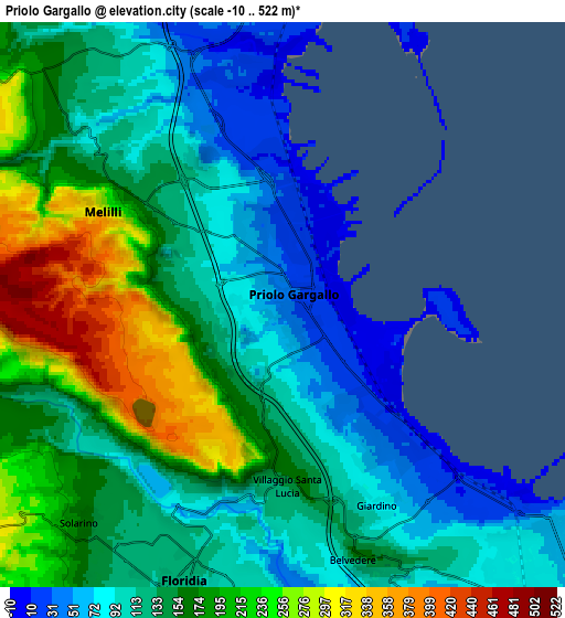
Below is the Elevation map of Priolo Gargallo, which displays elevation range with different colors. Scale of the first map is from -5 to 416 m (-16 to 1365 ft) with average elevation of 113.4 meters (=372 ft) [note 1]
These maps also provides idea of topography and contour of this city, they are displayed at different zoom levels. More info about maps, scale and edge coordinates you can find below images.
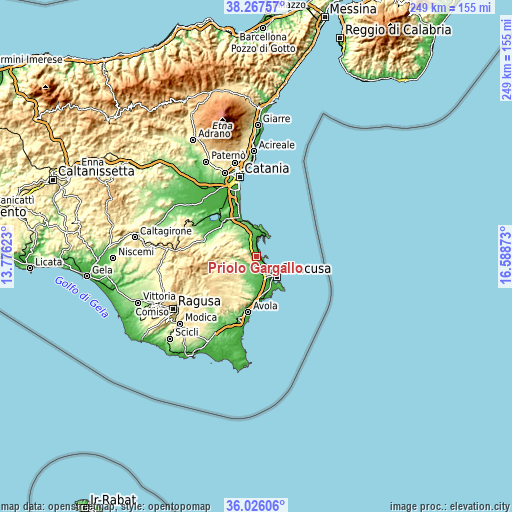
| \ | Map #1 | Map #2 | Topo.Map |
| Scale [m] | -5..416 m | -10..522 m | × |
| Scale [ft] | -16..1365 ft | -33..1713 ft | × |
| Average | 113.4 m = 372 ft | 146.6 m = 481 ft | × |
| Width | 7.79 km = 4.8 mi | 15.58 km = 9.7 mi | 249.2 km = 154.8 mi |
| Height | 7.79 km = 4.8 mi | 15.58 km = 9.7 mi | 249.2 km = 154.8 mi |
| ↑Max Latitude | 37.190136° | 37.225137° | 38.26757° |
| Latitude at center | 37.15512° | 37.15512° | 37.15512° |
| ↓Min Latitude | 37.120087° | 37.085038° | 36.02606° |
| ← Min Longitude | 15.138535° | 15.094589° | 13.77623° |
| Longitude center | 15.18248° | 15.18248° | 15.18248° |
| →Max Longitude | 15.226425° | 15.270371° | 16.58873° |
Nearby cities:
Cities around Priolo Gargallo sort by population:
• Siracusa elevation 22 m
12.8 km,  133°
133°
• Augusta 11 m
10.1 km,  19°
19°
• Floridia 116 m
8.4 km,  197°
197°
• Sortino 430 m
13.5 km,  271°
271°
• Solarino 171 m
8.2 km,  222°
222°
• Canicattini Bagni 376 m
17.3 km, 217°
• Melilli 254 m
5.3 km,  298°
298°
• Belvedere 123 m
7.9 km,  159°
159°
• Villasmundo 196 m
13.4 km,  322°
322°
• Città Giardino 90 m
6.2 km, 155°
• Carrozziere 12 m
15.3 km,  148°
148°
• Brucoli 10 m
14.1 km,  2°
2°
Multilingual:
 En español:
Priolo Gargallo elevación 38 m.
 En France:
Priolo Gargallo élévation 38 m.
 Auf Deutsch:
Priolo Gargallo höhe über dem Meeresspiegel ist 38 m.

Sources and notes:
- [note 1] Map square and city borders are not equal. Map elevation data is calculated only from area inside that square.
- [src 1] Elevation data from geonames database provided with same terms of usage.
- [src 2] The elevation map of Priolo Gargallo is generated using elevation data from NASA's 3 arcsec (90m) resolution SRTM data.
- [src 3] Base (background) map © OpenStreetMap contributors tiles are generated by Geofabrik and OpenTopoMap.
Copyright & License:
This Priolo Gargallo Elevation Map is licensed under CC BY-SA. You may reuse any part from this page, if you give a proper credit by linking to this URL:
 More info on terms of use page.