Pula elevation
Pula (Sardinia, Provincia di Cagliari), Italy elevation is 13 meters and Pula elevation in feet is 43 ft above sea level [src 1]. Pula is a seat of a third-order administrative division (feature code) with elevation that is 309 meters (1014 ft) smaller than average city elevation in Italy.
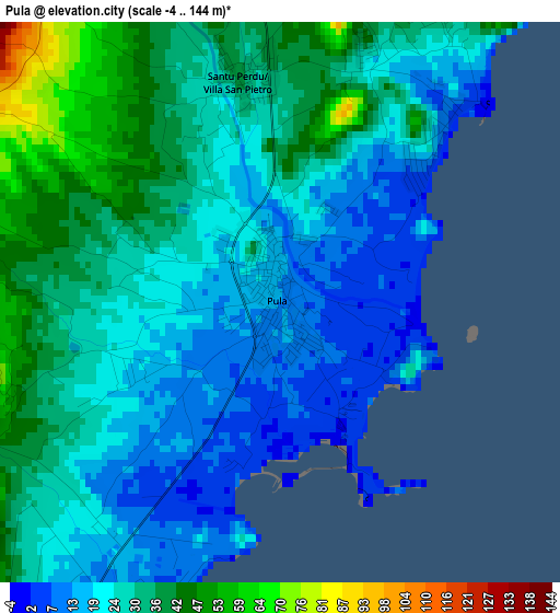
Below is the Elevation map of Pula, which displays elevation range with different colors. Scale of the first map is from -4 to 144 m (-13 to 472 ft) with average elevation of 26.9 meters (=88 ft) [note 1]
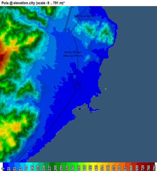
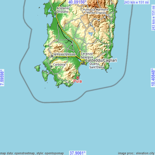
These maps also provides idea of topography and contour of this city, they are displayed at different zoom levels. More info about maps, scale and edge coordinates you can find below images.
| \ | Map #1 | Map #2 | Topo.Map |
| Scale [m] | -4..144 m | -9..791 m | × |
| Scale [ft] | -13..472 ft | -30..2595 ft | × |
| Average | 26.9 m = 88 ft | 132.4 m = 434 ft | × |
| Width | 7.59 km = 4.7 mi | 15.19 km = 9.4 mi | 243 km = 151 mi |
| Height | 7.59 km = 4.7 mi | 15.19 km = 9.4 mi | 243 km = 151 mi |
| ↑Max Latitude | 39.04141° | 39.075534° | 40.09156° |
| Latitude at center | 39.00727° | 39.00727° | 39.00727° |
| ↓Min Latitude | 38.973113° | 38.93894° | 37.9061° |
| ← Min Longitude | 8.958285° | 8.914339° | 7.59598° |
| Longitude center | 9.00223° | 9.00223° | 9.00223° |
| →Max Longitude | 9.046175° | 9.090121° | 10.40848° |
Nearby cities:
Cities around Pula sort by population:
• Cagliari elevation 41 m
26.8 km,  22°
22°
• Capoterra 50 m
18.9 km,  352°
352°
• Elmas 8 m
29.4 km,  8°
8°
• La Maddalena 6 m
15.3 km,  3°
3°
• Su Planu 55 m
29 km, 18°
• Sarroch 43 m
6.5 km, 5°
• Teulada 50 m
20.4 km,  257°
257°
• Poggio dei Pini 73 m
15.8 km, 350°
• Santadi 115 m
26.8 km,  290°
290°
• Villa San Pietro 34 m
3.2 km, 351°
• Nuxis 189 m
28 km,  305°
305°
• Domus de Maria 73 m
13.9 km,  239°
239°
Multilingual:
 En español:
Pula elevación 13 m.
 En France:
Pula élévation 13 m.


Sources and notes:
- [note 1] Map square and city borders are not equal. Map elevation data is calculated only from area inside that square.
- [src 1] Elevation data from geonames database provided with same terms of usage.
- [src 2] The elevation map of Pula is generated using elevation data from NASA's 3 arcsec (90m) resolution SRTM data.
- [src 3] Base (background) map © OpenStreetMap contributors tiles are generated by Geofabrik and OpenTopoMap.
Copyright & License:
This Pula Elevation Map is licensed under CC BY-SA. You may reuse any part from this page, if you give a proper credit by linking to this URL:
 More info on terms of use page.