Saracena elevation
Saracena (Calabria, Provincia di Cosenza), Italy elevation is 618 meters and Saracena elevation in feet is 2028 ft above sea level [src 1]. Saracena is a seat of a third-order administrative division (feature code) with elevation that is 296 meters (971 ft) bigger than average city elevation in Italy.
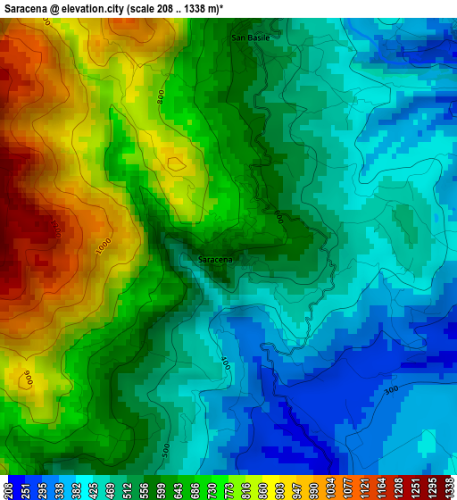
Below is the Elevation map of Saracena, which displays elevation range with different colors. Scale of the first map is from 208 to 1338 m (682 to 4390 ft) with average elevation of 599 meters (=1965 ft) [note 1]
These maps also provides idea of topography and contour of this city, they are displayed at different zoom levels. More info about maps, scale and edge coordinates you can find below images.
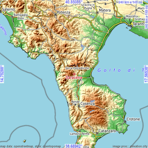
| \ | Map #1 | Topo.Map |
| Scale [m] | 208..1338 m | × |
| Scale [ft] | 682..4390 ft | × |
| Average | 599 m = 1965 ft | × |
| Width | 7.51 km = 4.7 mi | 240.3 km = 149.3 mi |
| Height | 7.51 km = 4.7 mi | 240.3 km = 149.3 mi |
| ↑Max Latitude | 39.812385° | 40.85085° |
| Latitude at center | 39.77862° | 39.77862° |
| ↓Min Latitude | 39.744839° | 38.68942° |
| ← Min Longitude | 16.115185° | 14.75288° |
| Longitude center | 16.15913° | 16.15913° |
| →Max Longitude | 16.203075° | 17.56538° |
Nearby cities:
Cities around Saracena sort by population:
• Castrovillari elevation 382 m
5.6 km,  41°
41°
• Cassano Allo Ionio 164 m
14.4 km,  88°
88°
• Morano Calabro 568 m
7.2 km,  345°
345°
• Lungro 564 m
5.4 km,  212°
212°
• Frascineto 469 m
10.8 km,  55°
55°
• Altomonte 466 m
9.2 km,  195°
195°
• Firmo 375 m
6.3 km,  176°
176°
• Acquaformosa 761 m
8.5 km,  223°
223°
• Mottafollone 374 m
16.6 km, 209°
• San Basile 548 m
3.5 km,  5°
5°
• Civita 426 m
14.3 km,  67°
67°
• San Donato di Ninea 800 m
12.1 km,  232°
232°
Multilingual:
 En español:
Saracena elevación 618 m.
 En France:
Saracena élévation 618 m.
 Auf Deutsch:
Saracena höhe über dem Meeresspiegel ist 618 m.

Sources and notes:
- [note 1] Map square and city borders are not equal. Map elevation data is calculated only from area inside that square.
- [src 1] Elevation data from geonames database provided with same terms of usage.
- [src 2] The elevation map of Saracena is generated using elevation data from NASA's 3 arcsec (90m) resolution SRTM data.
- [src 3] Base (background) map © OpenStreetMap contributors tiles are generated by Geofabrik and OpenTopoMap.
Copyright & License:
This Saracena Elevation Map is licensed under CC BY-SA. You may reuse any part from this page, if you give a proper credit by linking to this URL:
 More info on terms of use page.