Scandale elevation
Scandale (Calabria, Provincia di Crotone), Italy elevation is 372 meters and Scandale elevation in feet is 1220 ft above sea level [src 1]. Scandale is a seat of a third-order administrative division (feature code) with elevation that is 50 meters (164 ft) bigger than average city elevation in Italy.
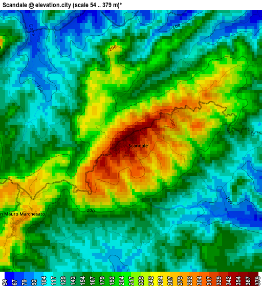
Below is the Elevation map of Scandale, which displays elevation range with different colors. Scale of the first map is from 54 to 379 m (177 to 1243 ft) with average elevation of 170.9 meters (=561 ft) [note 1]
These maps also provides idea of topography and contour of this city, they are displayed at different zoom levels. More info about maps, scale and edge coordinates you can find below images.
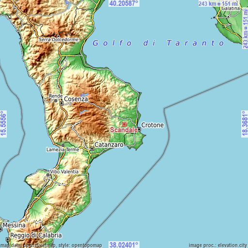
| \ | Map #1 | Topo.Map |
| Scale [m] | 54..379 m | × |
| Scale [ft] | 177..1243 ft | × |
| Average | 170.9 m = 561 ft | × |
| Width | 7.58 km = 4.7 mi | 242.6 km = 150.7 mi |
| Height | 7.58 km = 4.7 mi | 242.6 km = 150.7 mi |
| ↑Max Latitude | 39.157474° | 40.20587° |
| Latitude at center | 39.12339° | 39.12339° |
| ↓Min Latitude | 39.089289° | 38.02401° |
| ← Min Longitude | 16.917905° | 15.5556° |
| Longitude center | 16.96185° | 16.96185° |
| →Max Longitude | 17.005795° | 18.3681° |
Nearby cities:
Cities around Scandale sort by population:
• Crotone elevation 12 m
15.1 km,  108°
108°
• Cutro 222 m
10.1 km,  167°
167°
• Petilia Policastro 493 m
15.6 km,  265°
265°
• Rocca di Neto 48 m
7.7 km,  30°
30°
• Roccabernarda 147 m
8.8 km,  276°
276°
• Papanice 152 m
8.1 km,  136°
136°
• Casabona 273 m
14 km,  357°
357°
• Belvedere Spinello 251 m
11 km,  327°
327°
• San Mauro Marchesato 272 m
3.7 km,  237°
237°
• Santa Severina 230 m
5.1 km,  301°
301°
• Foresta 299 m
13.1 km,  258°
258°
• Marcedusa 297 m
15.3 km,  225°
225°
Multilingual:
 En español:
Scandale elevación 372 m.
 En France:
Scandale élévation 372 m.
 Auf Deutsch:
Scandale höhe über dem Meeresspiegel ist 372 m.

Sources and notes:
- [note 1] Map square and city borders are not equal. Map elevation data is calculated only from area inside that square.
- [src 1] Elevation data from geonames database provided with same terms of usage.
- [src 2] The elevation map of Scandale is generated using elevation data from NASA's 3 arcsec (90m) resolution SRTM data.
- [src 3] Base (background) map © OpenStreetMap contributors tiles are generated by Geofabrik and OpenTopoMap.
Copyright & License:
This Scandale Elevation Map is licensed under CC BY-SA. You may reuse any part from this page, if you give a proper credit by linking to this URL:
 More info on terms of use page.