Stilo elevation
Stilo (Calabria, Provincia di Reggio Calabria), Italy elevation is 365 meters and Stilo elevation in feet is 1198 ft above sea level [src 1]. Stilo is a seat of a third-order administrative division (feature code) with elevation that is 43 meters (141 ft) bigger than average city elevation in Italy.
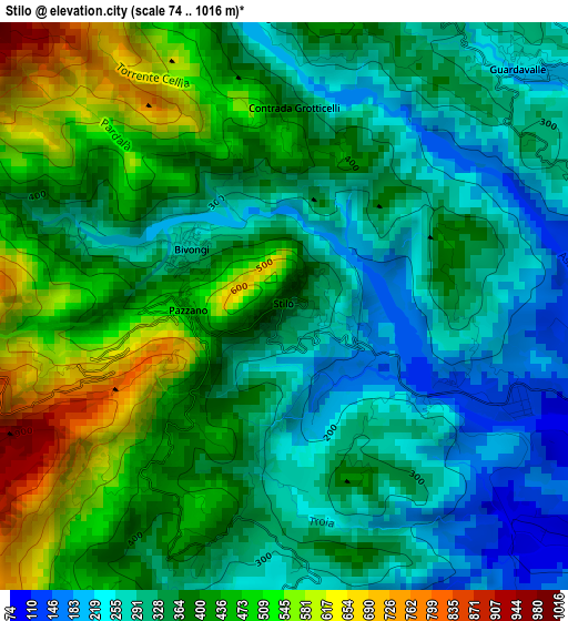
Below is the Elevation map of Stilo, which displays elevation range with different colors. Scale of the first map is from 74 to 1016 m (243 to 3333 ft) with average elevation of 375 meters (=1230 ft) [note 1]
These maps also provides idea of topography and contour of this city, they are displayed at different zoom levels. More info about maps, scale and edge coordinates you can find below images.
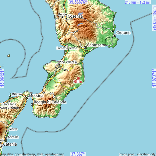
| \ | Map #1 | Topo.Map |
| Scale [m] | 74..1016 m | × |
| Scale [ft] | 243..3333 ft | × |
| Average | 375 m = 1230 ft | × |
| Width | 7.65 km = 4.8 mi | 244.8 km = 152.1 mi |
| Height | 7.65 km = 4.8 mi | 244.8 km = 152.1 mi |
| ↑Max Latitude | 38.510675° | 39.56876° |
| Latitude at center | 38.47628° | 38.47628° |
| ↓Min Latitude | 38.441869° | 37.367° |
| ← Min Longitude | 16.423515° | 15.06121° |
| Longitude center | 16.46746° | 16.46746° |
| →Max Longitude | 16.511405° | 17.87371° |
Nearby cities:
Cities around Stilo sort by population:
• Monasterace Marina elevation 19 m
10.1 km,  117°
117°
• Guardavalle Marina 16 m
9.5 km,  87°
87°
• Guardavalle 213 m
4.7 km,  46°
46°
• Bivongi 275 m
1.5 km,  300°
300°
• Santa Caterina dello Ionio Marina 7 m
10.6 km,  57°
57°
• Santa Caterina dello Ionio 475 m
7.9 km,  36°
36°
• Stignano 316 m
6.6 km,  177°
177°
• Placanica 263 m
7.4 km,  189°
189°
• Pazzano 466 m
1.4 km,  269°
269°
• Riace 291 m
6.6 km,  169°
169°
• Monasterace 131 m
7.8 km,  109°
109°
• Camini 295 m
5.1 km,  164°
164°
Multilingual:
 En español:
Stilo elevación 365 m.
 En France:
Stilo élévation 365 m.


Sources and notes:
- [note 1] Map square and city borders are not equal. Map elevation data is calculated only from area inside that square.
- [src 1] Elevation data from geonames database provided with same terms of usage.
- [src 2] The elevation map of Stilo is generated using elevation data from NASA's 3 arcsec (90m) resolution SRTM data.
- [src 3] Base (background) map © OpenStreetMap contributors tiles are generated by Geofabrik and OpenTopoMap.
Copyright & License:
This Stilo Elevation Map is licensed under CC BY-SA. You may reuse any part from this page, if you give a proper credit by linking to this URL:
 More info on terms of use page.