Terralba elevation
Terralba (Sardinia, Provincia di Oristano), Italy elevation is 13 meters and Terralba elevation in feet is 43 ft above sea level [src 1]. Terralba is a seat of a third-order administrative division (feature code) with elevation that is 309 meters (1014 ft) smaller than average city elevation in Italy.
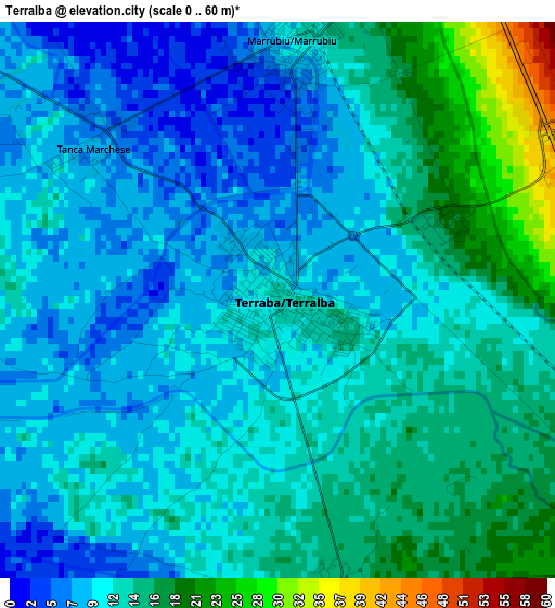
Below is the Elevation map of Terralba, which displays elevation range with different colors. Scale of the first map is from 0 to 60 m (0 to 197 ft) with average elevation of 12 meters (=39 ft) [note 1]
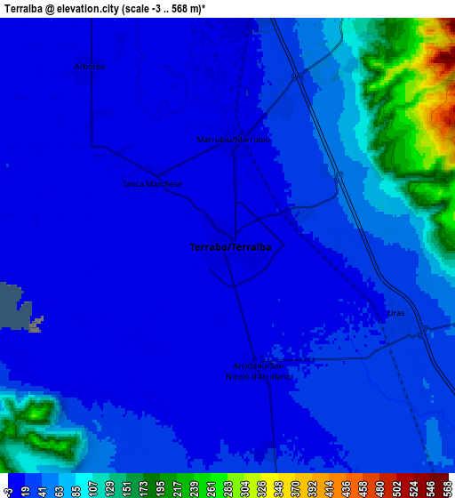
These maps also provides idea of topography and contour of this city, they are displayed at different zoom levels. More info about maps, scale and edge coordinates you can find below images.
| \ | Map #1 | Map #2 | Topo.Map |
| Scale [m] | 0..60 m | -3..568 m | × |
| Scale [ft] | 0..197 ft | -10..1864 ft | × |
| Average | 12 m = 39 ft | 42.3 m = 139 ft | × |
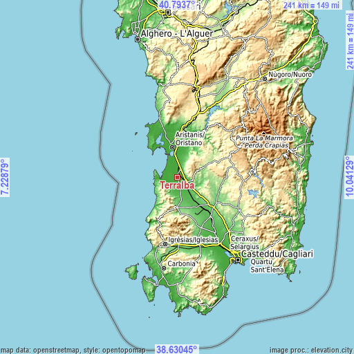
| Width | 7.52 km = 4.7 mi | 15.03 km = 9.3 mi | 240.5 km = 149.4 mi |
| Height | 7.52 km = 4.7 mi | 15.03 km = 9.3 mi | 240.5 km = 149.4 mi |
| ↑Max Latitude | 39.754353° | 39.78813° | 40.7937° |
| Latitude at center | 39.72056° | 39.72056° | 39.72056° |
| ↓Min Latitude | 39.68675° | 39.652924° | 38.63045° |
| ← Min Longitude | 8.591095° | 8.547149° | 7.22879° |
| Longitude center | 8.63504° | 8.63504° | 8.63504° |
| →Max Longitude | 8.678985° | 8.722931° | 10.04129° |
Nearby cities:
Cities around Terralba sort by population:
• Mogoro elevation 142 m
12.8 km,  108°
108°
• Marrubiu 10 m
3.4 km,  3°
3°
• Pabillonis 46 m
16.1 km,  152°
152°
• Uras 26 m
6.2 km, 113°
• San Nicolò d'Arcidano 13 m
4.1 km,  169°
169°
• Arborea 9 m
7.4 km,  321°
321°
• Ales 186 m
16.3 km,  70°
70°
• Masullas 135 m
12.9 km,  99°
99°
• Morgongiori 362 m
11.9 km,  76°
76°
• Pau 304 m
16.3 km,  61°
61°
• Pompu 142 m
13.8 km,  87°
87°
• Siris 165 m
12 km, 94°
Multilingual:
 En español:
Terralba elevación 13 m.
 En France:
Terralba élévation 13 m.


Sources and notes:
- [note 1] Map square and city borders are not equal. Map elevation data is calculated only from area inside that square.
- [src 1] Elevation data from geonames database provided with same terms of usage.
- [src 2] The elevation map of Terralba is generated using elevation data from NASA's 3 arcsec (90m) resolution SRTM data.
- [src 3] Base (background) map © OpenStreetMap contributors tiles are generated by Geofabrik and OpenTopoMap.
Copyright & License:
This Terralba Elevation Map is licensed under CC BY-SA. You may reuse any part from this page, if you give a proper credit by linking to this URL:
 More info on terms of use page.