Zumpano elevation
Zumpano (Calabria, Provincia di Cosenza), Italy elevation is 439 meters and Zumpano elevation in feet is 1440 ft above sea level [src 1]. Zumpano is a seat of a third-order administrative division (feature code) with elevation that is 117 meters (384 ft) bigger than average city elevation in Italy.
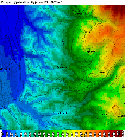
Below is the Elevation map of Zumpano, which displays elevation range with different colors. Scale of the first map is from 169 to 1057 m (554 to 3468 ft) with average elevation of 439.5 meters (=1442 ft) [note 1]
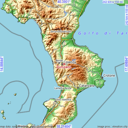
These maps also provides idea of topography and contour of this city, they are displayed at different zoom levels. More info about maps, scale and edge coordinates you can find below images.
| \ | Map #1 | Topo.Map |
| Scale [m] | 169..1057 m | × |
| Scale [ft] | 554..3468 ft | × |
| Average | 439.5 m = 1442 ft | × |
| Width | 7.56 km = 4.7 mi | 242 km = 150.4 mi |
| Height | 7.56 km = 4.7 mi | 241.9 km = 150.3 mi |
| ↑Max Latitude | 39.344523° | 40.3901° |
| Latitude at center | 39.31053° | 39.31053° |
| ↓Min Latitude | 39.27652° | 38.21404° |
| ← Min Longitude | 16.248745° | 14.88644° |
| Longitude center | 16.29269° | 16.29269° |
| →Max Longitude | 16.336635° | 17.69894° |
Nearby cities:
Cities around Zumpano sort by population:
• Cosenza elevation 245 m
3.6 km,  249°
249°
• Spezzano della Sila 774 m
4.2 km,  105°
105°
• Casole Bruzio 696 m
4.5 km,  131°
131°
• Rovito 670 m
2.2 km,  102°
102°
• Celico 757 m
4.1 km,  90°
90°
• Laurignano 427 m
5.6 km,  231°
231°
• Spezzano Piccolo 733 m
4.8 km,  118°
118°
• Pedace-Perito 624 m
5.3 km,  135°
135°
• San Pietro in Guarano 661 m
3.9 km,  26°
26°
• Castiglione Cosentino 384 m
4.7 km,  355°
355°
• Trenta 607 m
3.7 km, 138°
• Lappano 658 m
1.9 km,  57°
57°
Multilingual:
 En español:
Zumpano elevación 439 m.
 En France:
Zumpano élévation 439 m.


Sources and notes:
- [note 1] Map square and city borders are not equal. Map elevation data is calculated only from area inside that square.
- [src 1] Elevation data from geonames database provided with same terms of usage.
- [src 2] The elevation map of Zumpano is generated using elevation data from NASA's 3 arcsec (90m) resolution SRTM data.
- [src 3] Base (background) map © OpenStreetMap contributors tiles are generated by Geofabrik and OpenTopoMap.
Copyright & License:
This Zumpano Elevation Map is licensed under CC BY-SA. You may reuse any part from this page, if you give a proper credit by linking to this URL:
 More info on terms of use page.