Āmol elevation
Āmol (Māzandarān), Iran elevation is 96 meters and Āmol elevation in feet is 315 ft above sea level [src 1]. Āmol is a seat of a second-order administrative division (feature code) with elevation that is 948 meters (3110 ft) smaller than average city elevation in Iran.
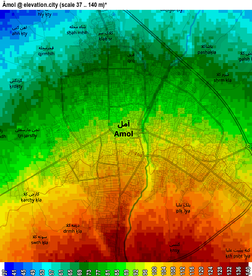
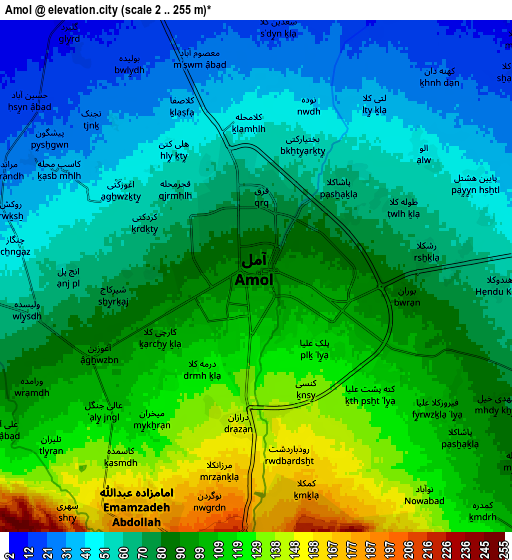
Below is the Elevation map of Āmol, which displays elevation range with different colors. Scale of the first map is from 37 to 140 m (121 to 459 ft) with average elevation of 90 meters (=295 ft) [note 1]
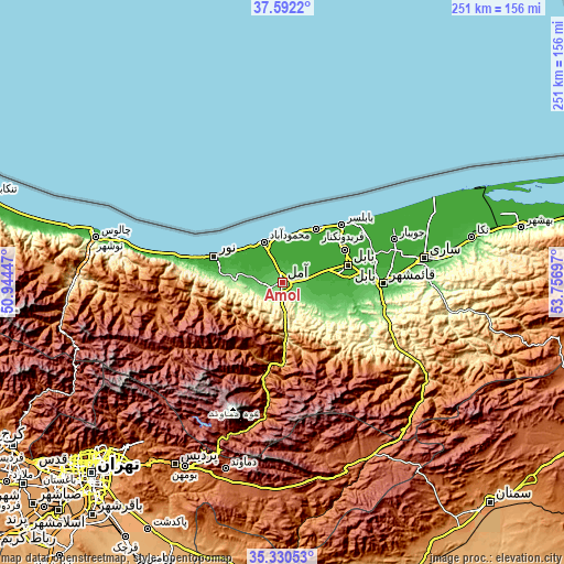
These maps also provides idea of topography and contour of this city, they are displayed at different zoom levels. More info about maps, scale and edge coordinates you can find below images.
| \ | Map #1 | Map #2 | Topo.Map |
| Scale [m] | 37..140 m | 2..255 m | × |
| Scale [ft] | 121..459 ft | 7..837 ft | × |
| Average | 90 m = 295 ft | 82.7 m = 271 ft | × |
| Width | 7.86 km = 4.9 mi | 15.72 km = 9.8 mi | 251.5 km = 156.3 mi |
| Height | 7.86 km = 4.9 mi | 15.72 km = 9.8 mi | 251.5 km = 156.3 mi |
| ↑Max Latitude | 36.504942° | 36.540257° | 37.5922° |
| Latitude at center | 36.46961° | 36.46961° | 36.46961° |
| ↓Min Latitude | 36.434262° | 36.398899° | 35.33053° |
| ← Min Longitude | 52.306775° | 52.262829° | 50.94447° |
| Longitude center | 52.35072° | 52.35072° | 52.35072° |
| →Max Longitude | 52.394665° | 52.438611° | 53.75697° |
Nearby cities:
Cities around Āmol sort by population:
• Sari elevation 43 m
64.2 km,  80°
80°
• Bābol -1 m
30.7 km,  72°
72°
• Bābolsar -21 m
37.7 km,  46°
46°
• Nowshahr -17 m
78.9 km,  284°
284°
• Fereydūnkenār -18 m
28.6 km,  32°
32°
• Jūybār -7 m
53.7 km, 69°
• Soleh Bon 2011 m
80.2 km,  166°
166°
• Sūrak 38 m
77.8 km, 79°
• Pol-e Sefīd 560 m
74.3 km,  121°
121°
• Qā’em Shahr 38 m
48.3 km,  88°
88°
• Nūr -18 m
32 km,  290°
290°
• Maḩmūdābād -23 m
19.7 km,  336°
336°
Multilingual:
 En español:
Āmol elevación 96 m.
 En France:
Āmol élévation 96 m.


Sources and notes:
- [note 1] Map square and city borders are not equal. Map elevation data is calculated only from area inside that square.
- [src 1] Elevation data from geonames database provided with same terms of usage.
- [src 2] The elevation map of Āmol is generated using elevation data from NASA's 3 arcsec (90m) resolution SRTM data.
- [src 3] Base (background) map © OpenStreetMap contributors tiles are generated by Geofabrik and OpenTopoMap.
Copyright & License:
This Āmol Elevation Map is licensed under CC BY-SA. You may reuse any part from this page, if you give a proper credit by linking to this URL:
 More info on terms of use page.