Borāzjān elevation
Borāzjān (Bushehr), Iran elevation is 70 meters and Borāzjān elevation in feet is 230 ft above sea level [src 1]. Borāzjān is a seat of a second-order administrative division (feature code) with elevation that is 974 meters (3196 ft) smaller than average city elevation in Iran.
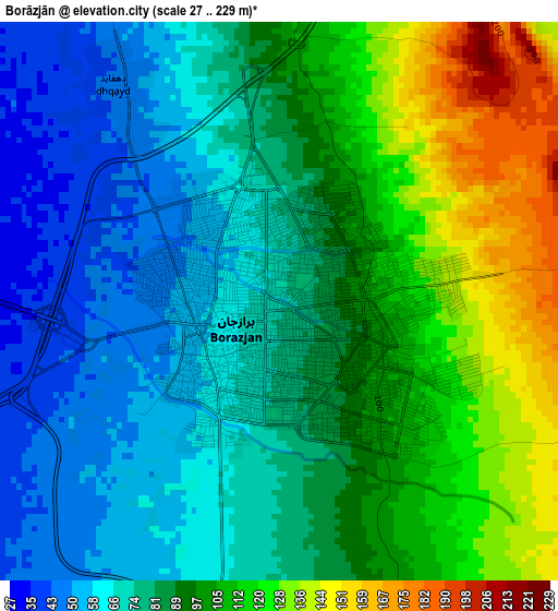
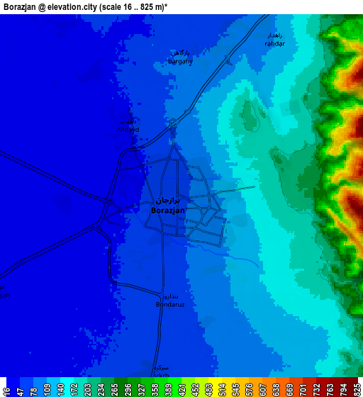
Below is the Elevation map of Borāzjān, which displays elevation range with different colors. Scale of the first map is from 27 to 229 m (89 to 751 ft) with average elevation of 89.3 meters (=293 ft) [note 1]
These maps also provides idea of topography and contour of this city, they are displayed at different zoom levels. More info about maps, scale and edge coordinates you can find below images.
| \ | Map #1 | Map #2 | Topo.Map |
| Scale [m] | 27..229 m | 16..825 m | × |
| Scale [ft] | 89..751 ft | 52..2707 ft | × |
| Average | 89.3 m = 293 ft | 114.6 m = 376 ft | × |
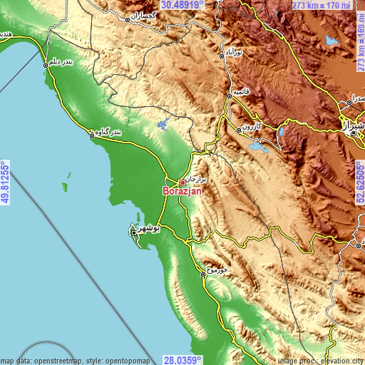
| Width | 8.52 km = 5.3 mi | 17.05 km = 10.6 mi | 272.8 km = 169.5 mi |
| Height | 8.52 km = 5.3 mi | 17.05 km = 10.6 mi | 272.8 km = 169.5 mi |
| ↑Max Latitude | 29.308227° | 29.346541° | 30.48919° |
| Latitude at center | 29.2699° | 29.2699° | 29.2699° |
| ↓Min Latitude | 29.231558° | 29.193202° | 28.0359° |
| ← Min Longitude | 51.174855° | 51.130909° | 49.81255° |
| Longitude center | 51.2188° | 51.2188° | 51.2188° |
| →Max Longitude | 51.262745° | 51.306691° | 52.62505° |
Nearby cities:
Cities around Borāzjān sort by population:
• Bushehr elevation 8 m
50 km,  227°
227°
• Dogonbadan 723 m
127.7 km,  341°
341°
• Kāzerūn 847 m
57.3 km,  47°
47°
• Nūrābād 951 m
98.3 km,  17°
17°
• Bandar-e Genāveh 8 m
76.2 km,  296°
296°
• Khārk 9 m
86.2 km,  269°
269°
• Sepīdān 2233 m
132.6 km,  33°
33°
• Bāsht 807 m
121.5 km,  357°
357°
• Maşīrī 886 m
112.4 km, 15°
• Farāshband 799 m
95.7 km,  117°
117°
• Khowrmūj 56 m
70.2 km,  167°
167°
• Ahram 63 m
43.4 km, 172°
Multilingual:
 En español:
Borāzjān elevación 70 m.
 En France:
Borāzjān élévation 70 m.


Sources and notes:
- [note 1] Map square and city borders are not equal. Map elevation data is calculated only from area inside that square.
- [src 1] Elevation data from geonames database provided with same terms of usage.
- [src 2] The elevation map of Borāzjān is generated using elevation data from NASA's 3 arcsec (90m) resolution SRTM data.
- [src 3] Base (background) map © OpenStreetMap contributors tiles are generated by Geofabrik and OpenTopoMap.
Copyright & License:
This Borāzjān Elevation Map is licensed under CC BY-SA. You may reuse any part from this page, if you give a proper credit by linking to this URL:
 More info on terms of use page.