Shahrud elevation
Shahrud (Semnan), Iran elevation is 1351 meters and Shahrud elevation in feet is 4432 ft above sea level [src 1]. Shahrud is a populated place (feature code) with elevation that is 307 meters (1007 ft) bigger than average city elevation in Iran.
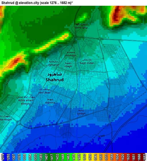
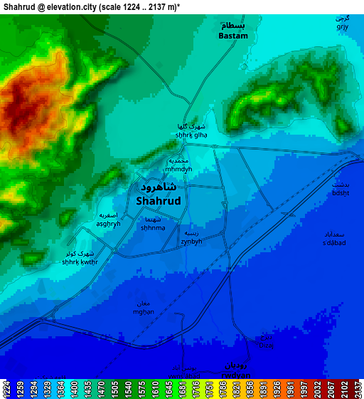
Below is the Elevation map of Shahrud, which displays elevation range with different colors. Scale of the first map is from 1276 to 1682 m (4186 to 5518 ft) with average elevation of 1360.8 meters (=4465 ft) [note 1]
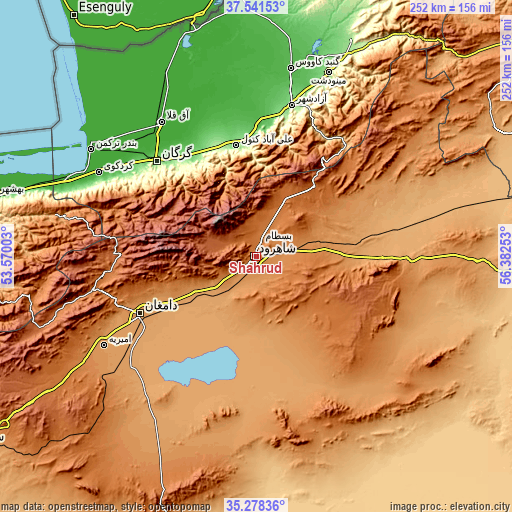
These maps also provides idea of topography and contour of this city, they are displayed at different zoom levels. More info about maps, scale and edge coordinates you can find below images.
| \ | Map #1 | Map #2 | Topo.Map |
| Scale [m] | 1276..1682 m | 1224..2137 m | × |
| Scale [ft] | 4186..5518 ft | 4016..7011 ft | × |
| Average | 1360.8 m = 4465 ft | 1398.4 m = 4588 ft | × |
| Width | 7.86 km = 4.9 mi | 15.73 km = 9.8 mi | 251.6 km = 156.3 mi |
| Height | 7.86 km = 4.9 mi | 15.73 km = 9.8 mi | 251.6 km = 156.3 mi |
| ↑Max Latitude | 36.453545° | 36.488884° | 37.54153° |
| Latitude at center | 36.41819° | 36.41819° | 36.41819° |
| ↓Min Latitude | 36.382819° | 36.347432° | 35.27836° |
| ← Min Longitude | 54.932335° | 54.888389° | 53.57003° |
| Longitude center | 54.97628° | 54.97628° | 54.97628° |
| →Max Longitude | 55.020225° | 55.064171° | 56.38253° |
Nearby cities:
Cities around Shahrud sort by population:
• Gorgān elevation 140 m
67 km,  314°
314°
• Gonbad-e Kāvūs 38 m
94 km,  10°
10°
• Dāmghān 1154 m
63.2 km,  243°
243°
• Āzādshahr 127 m
76.3 km, 13°
• Āq Qāyeh 37 m
96.6 km, 9°
• Qarnābād 262 m
56.5 km,  322°
322°
• Bandar-e Torkaman -22 m
96.9 km,  303°
303°
• Mīnūdasht 156 m
96.9 km,  21°
21°
• Kord Kūy -2 m
87.7 km, 298°
• Āq Qalā -13 m
80.9 km, 324°
• Rāmīān 222 m
68.1 km, 12°
• Aliabad-e Katul 134 m
55.6 km,  349°
349°
Multilingual:
 En español:
Shahrud elevación 1351 m.
 En France:
Shahrud élévation 1351 m.
 Auf Deutsch:
Emamshahr höhe über dem Meeresspiegel ist 1351 m.

Sources and notes:
- [note 1] Map square and city borders are not equal. Map elevation data is calculated only from area inside that square.
- [src 1] Elevation data from geonames database provided with same terms of usage.
- [src 2] The elevation map of Shahrud is generated using elevation data from NASA's 3 arcsec (90m) resolution SRTM data.
- [src 3] Base (background) map © OpenStreetMap contributors tiles are generated by Geofabrik and OpenTopoMap.
Copyright & License:
This Shahrud Elevation Map is licensed under CC BY-SA. You may reuse any part from this page, if you give a proper credit by linking to this URL:
 More info on terms of use page.