Gonbad-e Kāvūs elevation
Gonbad-e Kāvūs (Golestan), Iran elevation is 38 meters and Gonbad-e Kāvūs elevation in feet is 125 ft above sea level [src 1]. Gonbad-e Kāvūs is a seat of a second-order administrative division (feature code) with elevation that is 1006 meters (3301 ft) smaller than average city elevation in Iran.
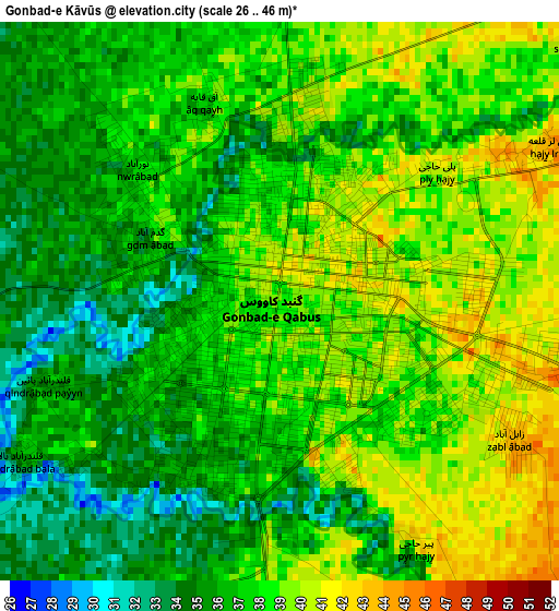
Below is the Elevation map of Gonbad-e Kāvūs, which displays elevation range with different colors. Scale of the first map is from 26 to 46 m (85 to 151 ft) with average elevation of 37.2 meters (=122 ft) [note 1]
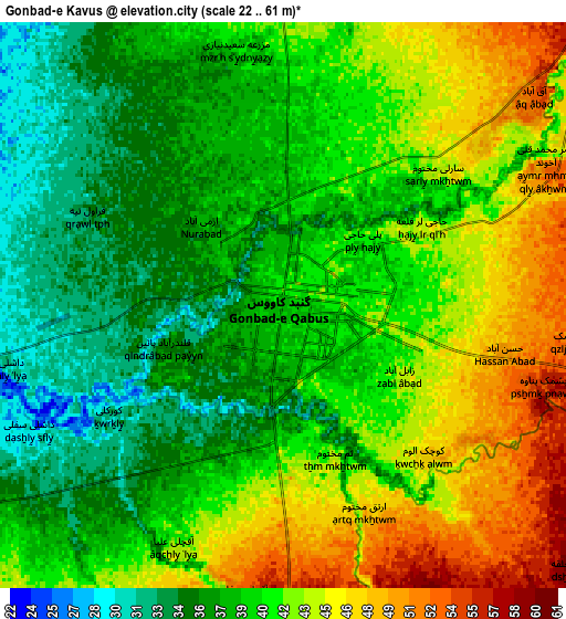
These maps also provides idea of topography and contour of this city, they are displayed at different zoom levels. More info about maps, scale and edge coordinates you can find below images.
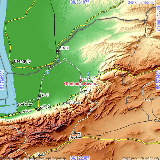
| \ | Map #1 | Map #2 | Topo.Map |
| Scale [m] | 26..46 m | 22..61 m | × |
| Scale [ft] | 85..151 ft | 72..200 ft | × |
| Average | 37.2 m = 122 ft | 40 m = 131 ft | × |
| Width | 7.78 km = 4.8 mi | 15.56 km = 9.7 mi | 248.9 km = 154.7 mi |
| Height | 7.78 km = 4.8 mi | 15.56 km = 9.7 mi | 248.9 km = 154.7 mi |
| ↑Max Latitude | 37.285012° | 37.319969° | 38.36107° |
| Latitude at center | 37.25004° | 37.25004° | 37.25004° |
| ↓Min Latitude | 37.215051° | 37.180046° | 36.12238° |
| ← Min Longitude | 55.123265° | 55.079319° | 53.76096° |
| Longitude center | 55.16721° | 55.16721° | 55.16721° |
| →Max Longitude | 55.211155° | 55.255101° | 56.57346° |
Nearby cities:
Cities around Gonbad-e Kāvūs sort by population:
• Gorgān elevation 140 m
78.6 km,  234°
234°
• Shahrud 1351 m
94 km,  190°
190°
• Āzādshahr 127 m
18.2 km,  178°
178°
• Kalāleh 152 m
32.2 km,  63°
63°
• Āq Qāyeh 37 m
2.8 km,  344°
344°
• Qarnābād 262 m
69.8 km, 227°
• Gomīshān -23 m
98.7 km,  258°
258°
• Āq Qalā -13 m
68.4 km,  247°
247°
• Aliabad-e Katul 134 m
46.2 km,  215°
215°
• Rāmīān 222 m
26.1 km, 185°
• Gālīkesh 195 m
23.7 km,  83°
83°
• Mīnūdasht 156 m
18.3 km,  96°
96°
Multilingual:
 En español:
Gonbad-e Kāvūs elevación 38 m.
 En France:
Gonbad-e Kāvūs élévation 38 m.
 Auf Deutsch:
Gonbad-e Kāvūs höhe über dem Meeresspiegel ist 38 m.

Sources and notes:
- [note 1] Map square and city borders are not equal. Map elevation data is calculated only from area inside that square.
- [src 1] Elevation data from geonames database provided with same terms of usage.
- [src 2] The elevation map of Gonbad-e Kāvūs is generated using elevation data from NASA's 3 arcsec (90m) resolution SRTM data.
- [src 3] Base (background) map © OpenStreetMap contributors tiles are generated by Geofabrik and OpenTopoMap.
Copyright & License:
This Gonbad-e Kāvūs Elevation Map is licensed under CC BY-SA. You may reuse any part from this page, if you give a proper credit by linking to this URL:
 More info on terms of use page.