Fīrūzābād elevation
Fīrūzābād (Fars), Iran elevation is 1330 meters and Fīrūzābād elevation in feet is 4364 ft above sea level [src 1]. Fīrūzābād is a seat of a second-order administrative division (feature code) with elevation that is 286 meters (938 ft) bigger than average city elevation in Iran.
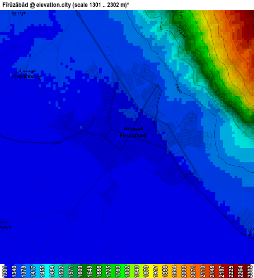
Below is the Elevation map of Fīrūzābād, which displays elevation range with different colors. Scale of the first map is from 1301 to 2302 m (4268 to 7552 ft) with average elevation of 1398.2 meters (=4587 ft) [note 1]
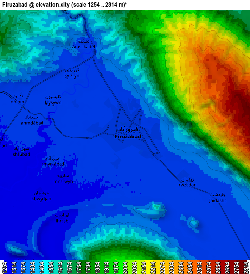
These maps also provides idea of topography and contour of this city, they are displayed at different zoom levels. More info about maps, scale and edge coordinates you can find below images.
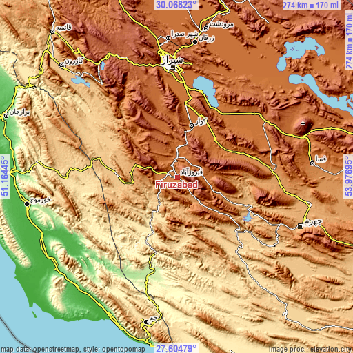
| \ | Map #1 | Map #2 | Topo.Map |
| Scale [m] | 1301..2302 m | 1254..2814 m | × |
| Scale [ft] | 4268..7552 ft | 4114..9232 ft | × |
| Average | 1398.2 m = 4587 ft | 1562.5 m = 5126 ft | × |
| Width | 8.56 km = 5.3 mi | 17.12 km = 10.6 mi | 273.9 km = 170.2 mi |
| Height | 8.56 km = 5.3 mi | 17.12 km = 10.6 mi | 273.9 km = 170.2 mi |
| ↑Max Latitude | 28.882286° | 28.920758° | 30.06823° |
| Latitude at center | 28.8438° | 28.8438° | 28.8438° |
| ↓Min Latitude | 28.8053° | 28.766785° | 27.60479° |
| ← Min Longitude | 52.526755° | 52.482809° | 51.16445° |
| Longitude center | 52.5707° | 52.5707° | 52.5707° |
| →Max Longitude | 52.614645° | 52.658591° | 53.97695° |
Nearby cities:
Cities around Fīrūzābād sort by population:
• Shiraz elevation 1545 m
85.3 km,  357°
357°
• Marvdasht 1603 m
116.8 km,  11°
11°
• Akbarābād 1518 m
49.1 km,  24°
24°
• Fasā 1366 m
105.4 km,  84°
84°
• Khowrmūj 56 m
118 km,  259°
259°
• Jam 637 m
115.5 km,  192°
192°
• Jahrom 1040 m
103.9 km,  111°
111°
• Kherāmeh 1593 m
102.4 km,  44°
44°
• Sarvestān 1542 m
79.2 km,  52°
52°
• Qīr 774 m
60.5 km,  131°
131°
• Farāshband 799 m
46.8 km,  273°
273°
• Kavār 1555 m
41.8 km, 16°
Multilingual:
 En español:
Fīrūzābād elevación 1330 m.
 En France:
Fīrūzābād élévation 1330 m.
 Auf Deutsch:
Fīrūzābād höhe über dem Meeresspiegel ist 1330 m.

Sources and notes:
- [note 1] Map square and city borders are not equal. Map elevation data is calculated only from area inside that square.
- [src 1] Elevation data from geonames database provided with same terms of usage.
- [src 2] The elevation map of Fīrūzābād is generated using elevation data from NASA's 3 arcsec (90m) resolution SRTM data.
- [src 3] Base (background) map © OpenStreetMap contributors tiles are generated by Geofabrik and OpenTopoMap.
Copyright & License:
This Fīrūzābād Elevation Map is licensed under CC BY-SA. You may reuse any part from this page, if you give a proper credit by linking to this URL:
 More info on terms of use page.