Marvdasht elevation
Marvdasht (Fars), Iran elevation is 1603 meters and Marvdasht elevation in feet is 5259 ft above sea level [src 1]. Marvdasht is a seat of a second-order administrative division (feature code) with elevation that is 559 meters (1834 ft) bigger than average city elevation in Iran.
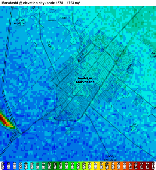
Below is the Elevation map of Marvdasht, which displays elevation range with different colors. Scale of the first map is from 1578 to 1723 m (5177 to 5653 ft) with average elevation of 1598.1 meters (=5243 ft) [note 1]
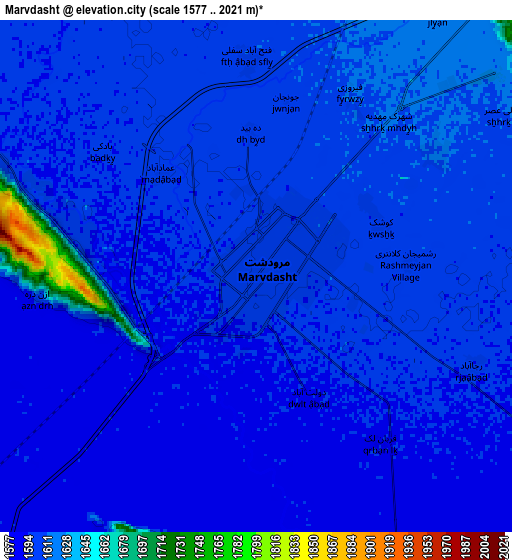
These maps also provides idea of topography and contour of this city, they are displayed at different zoom levels. More info about maps, scale and edge coordinates you can find below images.
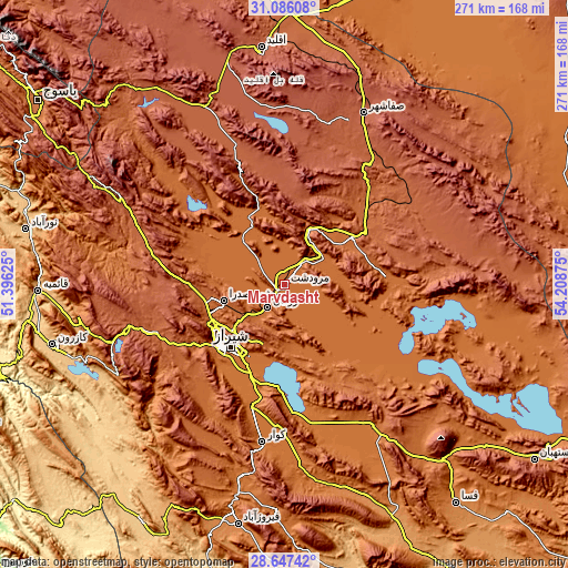
| \ | Map #1 | Map #2 | Topo.Map |
| Scale [m] | 1578..1723 m | 1577..2021 m | × |
| Scale [ft] | 5177..5653 ft | 5174..6631 ft | × |
| Average | 1598.1 m = 5243 ft | 1603.6 m = 5261 ft | × |
| Width | 8.47 km = 5.3 mi | 16.95 km = 10.5 mi | 271.2 km = 168.5 mi |
| Height | 8.47 km = 5.3 mi | 16.95 km = 10.5 mi | 271.2 km = 168.5 mi |
| ↑Max Latitude | 29.912299° | 29.950383° | 31.08608° |
| Latitude at center | 29.8742° | 29.8742° | 29.8742° |
| ↓Min Latitude | 29.836087° | 29.797959° | 28.64742° |
| ← Min Longitude | 52.758555° | 52.714609° | 51.39625° |
| Longitude center | 52.8025° | 52.8025° | 52.8025° |
| →Max Longitude | 52.846445° | 52.890391° | 54.20875° |
Nearby cities:
Cities around Marvdasht sort by population:
• Shiraz elevation 1545 m
39.3 km,  221°
221°
• Akbarābād 1518 m
69.8 km,  181°
181°
• Pāsārgād 1851 m
51.5 km,  44°
44°
• Eqlīd 2212 m
114.4 km,  354°
354°
• Sūrīān 2182 m
104 km,  51°
51°
• Şafāshahr 2299 m
90.4 km,  24°
24°
• Sepīdān 2233 m
89.7 km,  298°
298°
• Sarvestān 1542 m
78.1 km,  148°
148°
• Kavār 1555 m
75.2 km,  188°
188°
• Kherāmeh 1593 m
64.5 km,  130°
130°
• Arsanjān 1634 m
49 km,  85°
85°
• Sa‘ādat Shahr 1784 m
39.3 km, 54°
Multilingual:
 En español:
Marvdasht elevación 1603 m.
 En France:
Marvdasht élévation 1603 m.
 Auf Deutsch:
Marvdasht höhe über dem Meeresspiegel ist 1603 m.

Sources and notes:
- [note 1] Map square and city borders are not equal. Map elevation data is calculated only from area inside that square.
- [src 1] Elevation data from geonames database provided with same terms of usage.
- [src 2] The elevation map of Marvdasht is generated using elevation data from NASA's 3 arcsec (90m) resolution SRTM data.
- [src 3] Base (background) map © OpenStreetMap contributors tiles are generated by Geofabrik and OpenTopoMap.
Copyright & License:
This Marvdasht Elevation Map is licensed under CC BY-SA. You may reuse any part from this page, if you give a proper credit by linking to this URL:
 More info on terms of use page.