Harsīn elevation
Harsīn (Kermānshāh), Iran elevation is 1551 meters and Harsīn elevation in feet is 5089 ft above sea level [src 1]. Harsīn is a seat of a second-order administrative division (feature code) with elevation that is 507 meters (1663 ft) bigger than average city elevation in Iran.
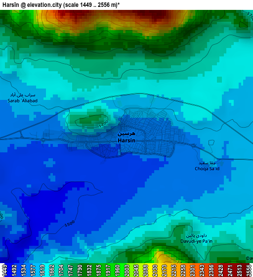
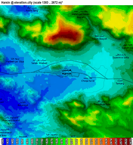
Below is the Elevation map of Harsīn, which displays elevation range with different colors. Scale of the first map is from 1449 to 2556 m (4754 to 8386 ft) with average elevation of 1656.9 meters (=5436 ft) [note 1]
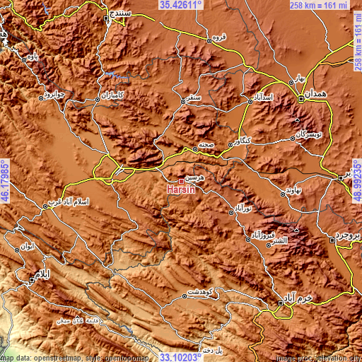
These maps also provides idea of topography and contour of this city, they are displayed at different zoom levels. More info about maps, scale and edge coordinates you can find below images.
| \ | Map #1 | Map #2 | Topo.Map |
| Scale [m] | 1449..2556 m | 1383..2672 m | × |
| Scale [ft] | 4754..8386 ft | 4537..8766 ft | × |
| Average | 1656.9 m = 5436 ft | 1744.9 m = 5725 ft | × |
| Width | 8.08 km = 5 mi | 16.15 km = 10 mi | 258.4 km = 160.6 mi |
| Height | 8.08 km = 5 mi | 16.15 km = 10 mi | 258.4 km = 160.6 mi |
| ↑Max Latitude | 34.308407° | 34.344699° | 35.42611° |
| Latitude at center | 34.2721° | 34.2721° | 34.2721° |
| ↓Min Latitude | 34.235777° | 34.199438° | 33.10203° |
| ← Min Longitude | 47.542155° | 47.498209° | 46.17985° |
| Longitude center | 47.5861° | 47.5861° | 47.5861° |
| →Max Longitude | 47.630045° | 47.673991° | 48.99235° |
Nearby cities:
Cities around Harsīn sort by population:
• Kahrīz elevation 1302 m
50.3 km,  284°
284°
• Kermanshah 1392 m
48.1 km, 275°
• Kūhdasht 1190 m
82.2 km,  178°
178°
• Nahāvand 1673 m
73 km,  97°
97°
• Nūrābād 1790 m
41.9 km,  121°
121°
• Kāmyārān 1470 m
83.3 km,  314°
314°
• Asadābād 1596 m
74.9 km,  40°
40°
• Kangāvar 1476 m
43.3 km,  53°
53°
• Sonqor 1697 m
56.7 km,  1°
1°
• Aleshtar 1614 m
77.1 km,  126°
126°
• Tūyserkān 1829 m
84.5 km,  68°
68°
• Şaḩneh 1364 m
25.2 km,  22°
22°
Multilingual:
 En español:
Harsīn elevación 1551 m.
 En France:
Harsīn élévation 1551 m.


Sources and notes:
- [note 1] Map square and city borders are not equal. Map elevation data is calculated only from area inside that square.
- [src 1] Elevation data from geonames database provided with same terms of usage.
- [src 2] The elevation map of Harsīn is generated using elevation data from NASA's 3 arcsec (90m) resolution SRTM data.
- [src 3] Base (background) map © OpenStreetMap contributors tiles are generated by Geofabrik and OpenTopoMap.
Copyright & License:
This Harsīn Elevation Map is licensed under CC BY-SA. You may reuse any part from this page, if you give a proper credit by linking to this URL:
 More info on terms of use page.