Kermanshah elevation
Kermanshah (Kermānshāh), Iran elevation is 1392 meters and Kermanshah elevation in feet is 4567 ft above sea level [src 1]. Kermanshah is a seat of a first-order administrative division (feature code) with elevation that is 348 meters (1142 ft) bigger than average city elevation in Iran.
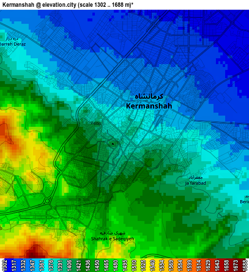
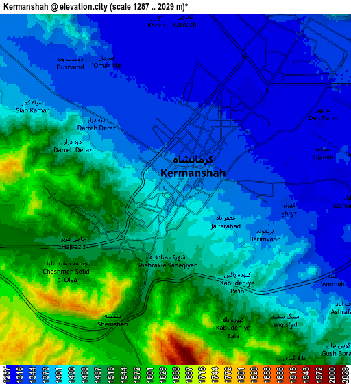
Below is the Elevation map of Kermanshah, which displays elevation range with different colors. Scale of the first map is from 1302 to 1688 m (4272 to 5538 ft) with average elevation of 1401.5 meters (=4598 ft) [note 1]
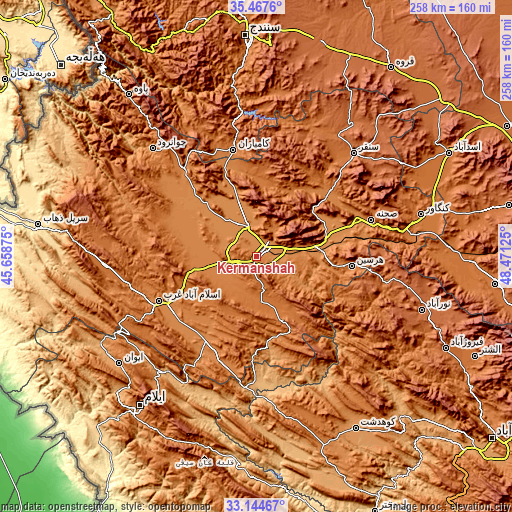
These maps also provides idea of topography and contour of this city, they are displayed at different zoom levels. More info about maps, scale and edge coordinates you can find below images.
| \ | Map #1 | Map #2 | Topo.Map |
| Scale [m] | 1302..1688 m | 1287..2029 m | × |
| Scale [ft] | 4272..5538 ft | 4222..6657 ft | × |
| Average | 1401.5 m = 4598 ft | 1438.4 m = 4719 ft | × |
| Width | 8.07 km = 5 mi | 16.14 km = 10 mi | 258.3 km = 160.5 mi |
| Height | 8.07 km = 5 mi | 16.14 km = 10 mi | 258.3 km = 160.5 mi |
| ↑Max Latitude | 34.350459° | 34.386733° | 35.4676° |
| Latitude at center | 34.31417° | 34.31417° | 34.31417° |
| ↓Min Latitude | 34.277865° | 34.241545° | 33.14467° |
| ← Min Longitude | 47.021055° | 46.977109° | 45.65875° |
| Longitude center | 47.065° | 47.065° | 47.065° |
| →Max Longitude | 47.108945° | 47.152891° | 48.47125° |
Nearby cities:
Cities around Kermanshah sort by population:
• Kahrīz elevation 1302 m
7.8 km,  353°
353°
• Kāmyārān 1470 m
54.8 km, 347°
• Harsīn 1551 m
48.1 km,  95°
95°
• Kangāvar 1476 m
85.3 km,  75°
75°
• Sonqor 1697 m
71.4 km,  43°
43°
• Javānrūd 1418 m
73.4 km,  316°
316°
• Sarābleh 1027 m
76.2 km,  217°
217°
• Javānrūd 1317 m
75.9 km, 316°
• Kerend-e Gharb 1588 m
75.6 km,  267°
267°
• Şaḩneh 1364 m
60.3 km,  72°
72°
• Ravānsar 1345 m
58.4 km, 319°
• Eslāmābād-e Gharb 1332 m
54.4 km,  245°
245°
Multilingual:
 En español:
Kermanshah elevación 1392 m.
 En France:
Kermanshah élévation 1392 m.
 Auf Deutsch:
Kermānschāh höhe über dem Meeresspiegel ist 1392 m.

Sources and notes:
- [note 1] Map square and city borders are not equal. Map elevation data is calculated only from area inside that square.
- [src 1] Elevation data from geonames database provided with same terms of usage.
- [src 2] The elevation map of Kermanshah is generated using elevation data from NASA's 3 arcsec (90m) resolution SRTM data.
- [src 3] Base (background) map © OpenStreetMap contributors tiles are generated by Geofabrik and OpenTopoMap.
Copyright & License:
This Kermanshah Elevation Map is licensed under CC BY-SA. You may reuse any part from this page, if you give a proper credit by linking to this URL:
 More info on terms of use page.