Masjed Soleymān elevation
Masjed Soleymān (Khuzestan), Iran elevation is 240 meters and Masjed Soleymān elevation in feet is 787 ft above sea level [src 1]. Masjed Soleymān is a seat of a second-order administrative division (feature code) with elevation that is 804 meters (2638 ft) smaller than average city elevation in Iran.
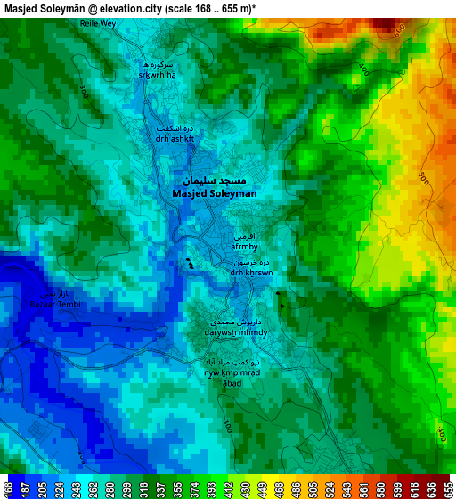
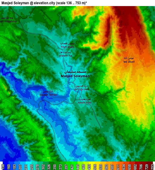
Below is the Elevation map of Masjed Soleymān, which displays elevation range with different colors. Scale of the first map is from 168 to 655 m (551 to 2149 ft) with average elevation of 310 meters (=1017 ft) [note 1]
These maps also provides idea of topography and contour of this city, they are displayed at different zoom levels. More info about maps, scale and edge coordinates you can find below images.
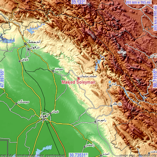
| \ | Map #1 | Map #2 | Topo.Map |
| Scale [m] | 168..655 m | 136..753 m | × |
| Scale [ft] | 551..2149 ft | 446..2470 ft | × |
| Average | 310 m = 1017 ft | 366.6 m = 1203 ft | × |
| Width | 8.29 km = 5.2 mi | 16.59 km = 10.3 mi | 265.4 km = 164.9 mi |
| Height | 8.29 km = 5.2 mi | 16.59 km = 10.3 mi | 265.4 km = 164.9 mi |
| ↑Max Latitude | 31.973686° | 32.010957° | 33.122° |
| Latitude at center | 31.9364° | 31.9364° | 31.9364° |
| ↓Min Latitude | 31.899099° | 31.861783° | 30.73531° |
| ← Min Longitude | 49.259955° | 49.216009° | 47.89765° |
| Longitude center | 49.3039° | 49.3039° | 49.3039° |
| →Max Longitude | 49.347845° | 49.391791° | 50.71015° |
Nearby cities:
Cities around Masjed Soleymān sort by population:
• Ahvaz elevation 23 m
90.3 km,  220°
220°
• Shūshtar 50 m
44.8 km,  286°
286°
• Rāmhormoz 160 m
78.3 km,  158°
158°
• Shahrak-e Kūlūrī 140 m
91.1 km,  300°
300°
• sedeyen-e Yek 21 m
78.7 km, 215°
• Dezful 143 m
97.9 km, 300°
• Chelgard 2331 m
97 km,  52°
52°
• Bāgh-e Malek 711 m
71.6 km,  129°
129°
• Haftkel 298 m
58.5 km, 158°
• Mollās̄ānī 28 m
55.6 km,  225°
225°
• Dasht-e Lati 381 m
48 km,  335°
335°
• Qal‘eh-ye Khvājeh 753 m
32.8 km,  23°
23°
Multilingual:
 En español:
Masjed Soleymān elevación 240 m.
 En France:
Masjed Soleymān élévation 240 m.
 Auf Deutsch:
Masjed Soleymān höhe über dem Meeresspiegel ist 240 m.

Sources and notes:
- [note 1] Map square and city borders are not equal. Map elevation data is calculated only from area inside that square.
- [src 1] Elevation data from geonames database provided with same terms of usage.
- [src 2] The elevation map of Masjed Soleymān is generated using elevation data from NASA's 3 arcsec (90m) resolution SRTM data.
- [src 3] Base (background) map © OpenStreetMap contributors tiles are generated by Geofabrik and OpenTopoMap.
Copyright & License:
This Masjed Soleymān Elevation Map is licensed under CC BY-SA. You may reuse any part from this page, if you give a proper credit by linking to this URL:
 More info on terms of use page.