Mohr elevation
Mohr (Fars), Iran elevation is 439 meters and Mohr elevation in feet is 1440 ft above sea level [src 1]. Mohr is a seat of a second-order administrative division (feature code) with elevation that is 605 meters (1985 ft) smaller than average city elevation in Iran.
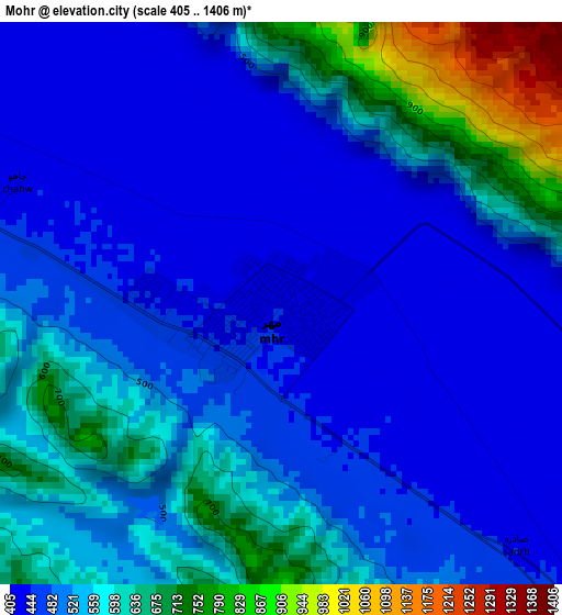
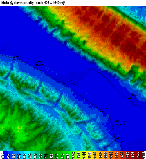
Below is the Elevation map of Mohr, which displays elevation range with different colors. Scale of the first map is from 405 to 1406 m (1329 to 4613 ft) with average elevation of 535.8 meters (=1758 ft) [note 1]
These maps also provides idea of topography and contour of this city, they are displayed at different zoom levels. More info about maps, scale and edge coordinates you can find below images.
| \ | Map #1 | Map #2 | Topo.Map |
| Scale [m] | 405..1406 m | 405..1619 m | × |
| Scale [ft] | 1329..4613 ft | 1329..5312 ft | × |
| Average | 535.8 m = 1758 ft | 715.8 m = 2348 ft | × |
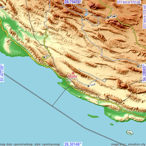
| Width | 8.66 km = 5.4 mi | 17.33 km = 10.8 mi | 277.2 km = 172.2 mi |
| Height | 8.66 km = 5.4 mi | 17.33 km = 10.8 mi | 277.2 km = 172.2 mi |
| ↑Max Latitude | 27.594153° | 27.633093° | 28.79478° |
| Latitude at center | 27.5552° | 27.5552° | 27.5552° |
| ↓Min Latitude | 27.516233° | 27.477252° | 26.30146° |
| ← Min Longitude | 52.839655° | 52.795709° | 51.47735° |
| Longitude center | 52.8836° | 52.8836° | 52.8836° |
| →Max Longitude | 52.927545° | 52.971491° | 54.28985° |
Nearby cities:
Cities around Mohr sort by population:
• Fīrūzābād elevation 1330 m
146.5 km,  347°
347°
• Gerāsh 923 m
124 km,  84°
84°
• Shahr-e Qadīm-e Lār 818 m
144.4 km, 84°
• Jahrom 1040 m
124.3 km,  32°
32°
• Qīr 774 m
104.2 km,  8°
8°
• Deyr 9 m
98.3 km,  288°
288°
• Kangān 11 m
86.6 km, 290°
• Khonj 671 m
65.8 km,  55°
55°
• Jam 637 m
62.8 km,  298°
298°
• Gāvbandī 58 m
41.4 km,  158°
158°
• Lāmerd 425 m
38.1 km,  130°
130°
• Bandar-e ‘Asalūyeh 4 m
28.6 km,  252°
252°
Multilingual:
 En español:
Mohr elevación 439 m.
 En France:
Mohr élévation 439 m.


Sources and notes:
- [note 1] Map square and city borders are not equal. Map elevation data is calculated only from area inside that square.
- [src 1] Elevation data from geonames database provided with same terms of usage.
- [src 2] The elevation map of Mohr is generated using elevation data from NASA's 3 arcsec (90m) resolution SRTM data.
- [src 3] Base (background) map © OpenStreetMap contributors tiles are generated by Geofabrik and OpenTopoMap.
Copyright & License:
This Mohr Elevation Map is licensed under CC BY-SA. You may reuse any part from this page, if you give a proper credit by linking to this URL:
 More info on terms of use page.