Qarah Ẕīā’ od Dīn elevation
Qarah Ẕīā’ od Dīn (West Azerbaijan), Iran elevation is 1090 meters and Qarah Ẕīā’ od Dīn elevation in feet is 3576 ft above sea level [src 1]. Qarah Ẕīā’ od Dīn is a seat of a second-order administrative division (feature code) with elevation that is 46 meters (151 ft) bigger than average city elevation in Iran.
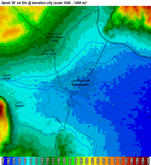
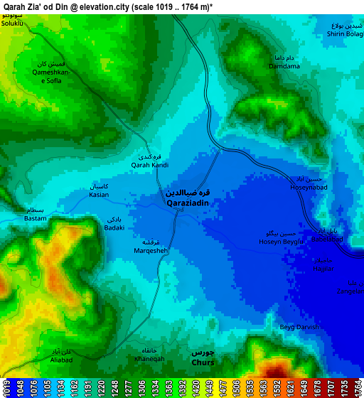
Below is the Elevation map of Qarah Ẕīā’ od Dīn, which displays elevation range with different colors. Scale of the first map is from 1048 to 1408 m (3438 to 4619 ft) with average elevation of 1125.8 meters (=3694 ft) [note 1]
These maps also provides idea of topography and contour of this city, they are displayed at different zoom levels. More info about maps, scale and edge coordinates you can find below images.
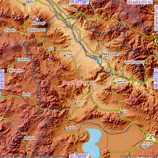
| \ | Map #1 | Map #2 | Topo.Map |
| Scale [m] | 1048..1408 m | 1019..1764 m | × |
| Scale [ft] | 3438..4619 ft | 3343..5787 ft | × |
| Average | 1125.8 m = 3694 ft | 1204.9 m = 3953 ft | × |
| Width | 7.61 km = 4.7 mi | 15.21 km = 9.5 mi | 243.4 km = 151.2 mi |
| Height | 7.61 km = 4.7 mi | 15.21 km = 9.5 mi | 243.4 km = 151.2 mi |
| ↑Max Latitude | 38.925696° | 38.959876° | 39.97758° |
| Latitude at center | 38.8915° | 38.8915° | 38.8915° |
| ↓Min Latitude | 38.857288° | 38.823059° | 37.78856° |
| ← Min Longitude | 44.981555° | 44.937609° | 43.61925° |
| Longitude center | 45.0255° | 45.0255° | 45.0255° |
| →Max Longitude | 45.069445° | 45.113391° | 46.43175° |
Nearby cities:
Cities around Qarah Ẕīā’ od Dīn sort by population:
• Tabriz elevation 1396 m
142.4 km,  129°
129°
• Orūmīyeh 1350 m
148.9 km,  178°
178°
• Khowy 1143 m
38.5 km,  189°
189°
• Marand 1322 m
82.7 km, 128°
• Salmās 1382 m
80.4 km,  196°
196°
• Oskū 1512 m
144.7 km,  138°
138°
• Shabestar 1433 m
98.6 km, 143°
• Varazqān 1532 m
97.2 km,  104°
104°
• Maku 1228 m
65.9 km,  312°
312°
• Seyah Cheshmeh 1832 m
58.7 km,  289°
289°
• Poldasht 783 m
50.9 km,  4°
4°
• Showţ 994 m
42.6 km,  328°
328°
Multilingual:
 En español:
Qarah Ẕīā’ od Dīn elevación 1090 m.
 En France:
Qarah Ẕīā’ od Dīn élévation 1090 m.
 Auf Deutsch:
Qarah Ẕīā’ od Dīn höhe über dem Meeresspiegel ist 1090 m.
 На русском:
Qarah Ẕīā’ od Dīn высота над уровнем моря 1090 м
Sources and notes:
- [note 1] Map square and city borders are not equal. Map elevation data is calculated only from area inside that square.
- [src 1] Elevation data from geonames database provided with same terms of usage.
- [src 2] The elevation map of Qarah Ẕīā’ od Dīn is generated using elevation data from NASA's 3 arcsec (90m) resolution SRTM data.
- [src 3] Base (background) map © OpenStreetMap contributors tiles are generated by Geofabrik and OpenTopoMap.
Copyright & License:
This Qarah Ẕīā’ od Dīn Elevation Map is licensed under CC BY-SA. You may reuse any part from this page, if you give a proper credit by linking to this URL:
 More info on terms of use page.