Sinjār elevation
Sinjār (Nineveh, Sinjar), Iraq elevation is 517 meters and Sinjār elevation in feet is 1696 ft above sea level [src 1]. Sinjār is a seat of a second-order administrative division (feature code) with elevation that is 224 meters (735 ft) bigger than average city elevation in Iraq.
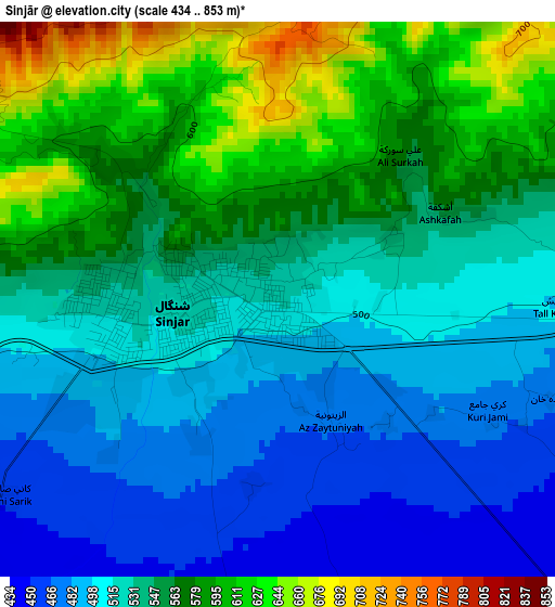
Below is the Elevation map of Sinjār, which displays elevation range with different colors. Scale of the first map is from 434 to 853 m (1424 to 2799 ft) with average elevation of 539.7 meters (=1771 ft) [note 1]
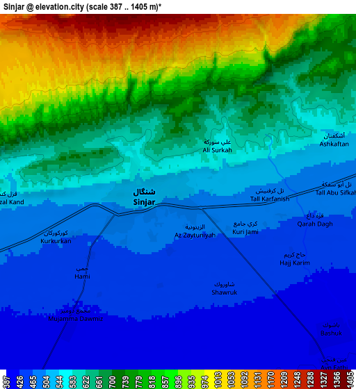
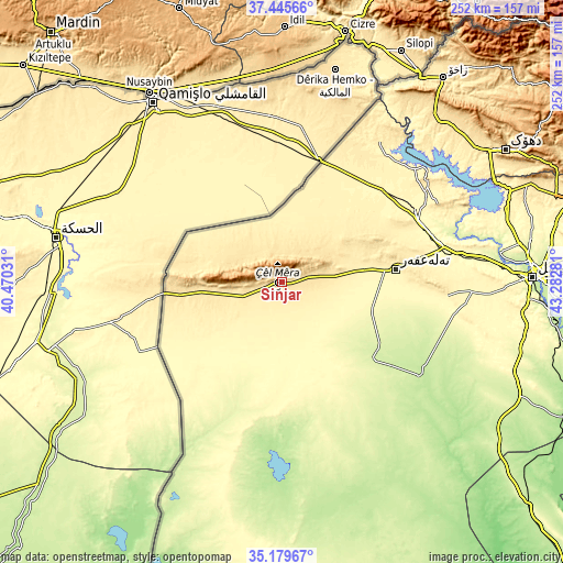
These maps also provides idea of topography and contour of this city, they are displayed at different zoom levels. More info about maps, scale and edge coordinates you can find below images.
| \ | Map #1 | Map #2 | Topo.Map |
| Scale [m] | 434..853 m | 387..1405 m | × |
| Scale [ft] | 1424..2799 ft | 1270..4610 ft | × |
| Average | 539.7 m = 1771 ft | 620.1 m = 2034 ft | × |
| Width | 7.87 km = 4.9 mi | 15.75 km = 9.8 mi | 252 km = 156.6 mi |
| Height | 7.87 km = 4.9 mi | 15.75 km = 9.8 mi | 252 km = 156.6 mi |
| ↑Max Latitude | 36.356299° | 36.391682° | 37.44566° |
| Latitude at center | 36.3209° | 36.3209° | 36.3209° |
| ↓Min Latitude | 36.285485° | 36.250053° | 35.17967° |
| ← Min Longitude | 41.832615° | 41.788669° | 40.47031° |
| Longitude center | 41.87656° | 41.87656° | 41.87656° |
| →Max Longitude | 41.920505° | 41.964451° | 43.28281° |
Nearby cities:
Cities around Sinjār sort by population:
• Al Mawşil al Jadīdah elevation 239 m
110.1 km,  89°
89°
• Mosul 228 m
111.3 km, 89°
• Dihok 567 m
116.4 km,  58°
58°
• Sīnah 669 m
117.1 km, 62°
• Zaxo 439 m
116.9 km,  38°
38°
• Tallkayf 279 m
113 km,  80°
80°
• Zaxu 437 m
116.2 km, 38°
• Al Ḩaḑar 207 m
113.5 km,  137°
137°
• Ibrāhīm al Khalīl 397 m
110 km,  34°
34°
• Saymayl 465 m
105.3 km, 55°
• Tall ‘Afar 407 m
51.6 km, 82°
• Al Ba‘āj 317 m
34.1 km,  204°
204°
Multilingual:
 En español:
Sinjār elevación 517 m.
 En France:
Sinjār élévation 517 m.


Sources and notes:
- [note 1] Map square and city borders are not equal. Map elevation data is calculated only from area inside that square.
- [src 1] Elevation data from geonames database provided with same terms of usage.
- [src 2] The elevation map of Sinjār is generated using elevation data from NASA's 3 arcsec (90m) resolution SRTM data.
- [src 3] Base (background) map © OpenStreetMap contributors tiles are generated by Geofabrik and OpenTopoMap.
Copyright & License:
This Sinjār Elevation Map is licensed under CC BY-SA. You may reuse any part from this page, if you give a proper credit by linking to this URL:
 More info on terms of use page.