Al Ḩillah elevation
Al Ḩillah (Bābil, Al-Musayab District), Iraq elevation is 33 meters and Al Ḩillah elevation in feet is 108 ft above sea level [src 1]. Al Ḩillah is a seat of a first-order administrative division (feature code) with elevation that is 260 meters (853 ft) smaller than average city elevation in Iraq.
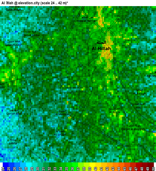
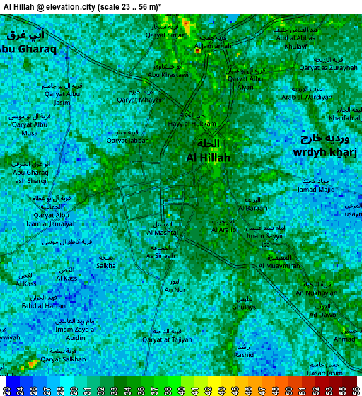
Below is the Elevation map of Al Ḩillah, which displays elevation range with different colors. Scale of the first map is from 24 to 42 m (79 to 138 ft) with average elevation of 32 meters (=105 ft) [note 1]
These maps also provides idea of topography and contour of this city, they are displayed at different zoom levels. More info about maps, scale and edge coordinates you can find below images.
| \ | Map #1 | Map #2 | Topo.Map |
| Scale [m] | 24..42 m | 23..56 m | × |
| Scale [ft] | 79..138 ft | 75..184 ft | × |
| Average | 32 m = 105 ft | 30.8 m = 101 ft | × |
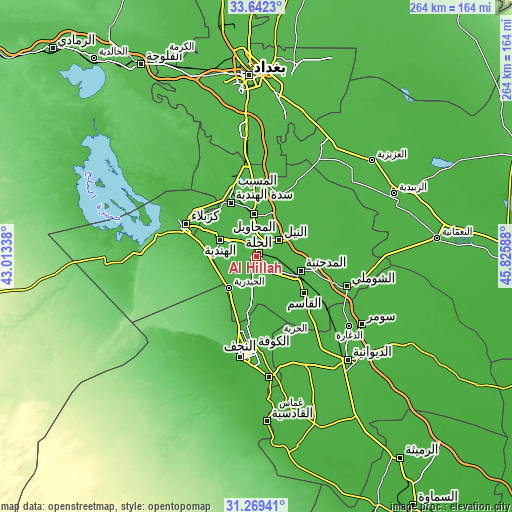
| Width | 8.25 km = 5.1 mi | 16.49 km = 10.2 mi | 263.8 km = 163.9 mi |
| Height | 8.25 km = 5.1 mi | 16.49 km = 10.2 mi | 263.8 km = 163.9 mi |
| ↑Max Latitude | 32.50074° | 32.537796° | 33.6423° |
| Latitude at center | 32.46367° | 32.46367° | 32.46367° |
| ↓Min Latitude | 32.426584° | 32.389483° | 31.26941° |
| ← Min Longitude | 44.375685° | 44.331739° | 43.01338° |
| Longitude center | 44.41963° | 44.41963° | 44.41963° |
| →Max Longitude | 44.463575° | 44.507521° | 45.82588° |
Nearby cities:
Cities around Al Ḩillah sort by population:
• Najaf elevation 41 m
49.2 km,  188°
188°
• Karbala 32 m
40.7 km,  294°
294°
• Kufa 24 m
45.9 km,  177°
177°
• Ash Shāmīyah 23 m
58.3 km,  162°
162°
• Al Hindīyah 36 m
20.2 km,  297°
297°
• Al Musayyib 37 m
37.1 km,  340°
340°
• Aş Şuwayrah 32 m
61.2 km,  32°
32°
• Imam Qasim 30 m
30.8 km,  126°
126°
• Nāḩīyat Saddat al Hindīyah 36 m
31 km,  334°
334°
• Al Manādhirah 27 m
62.2 km,  174°
174°
• Al Hāshimīyah 28 m
25.2 km,  116°
116°
• Al Maḩāwīl 30 m
22 km,  357°
357°
Multilingual:
 En español:
Al Ḩillah elevación 33 m.
 En France:
Hilla élévation 33 m.


Sources and notes:
- [note 1] Map square and city borders are not equal. Map elevation data is calculated only from area inside that square.
- [src 1] Elevation data from geonames database provided with same terms of usage.
- [src 2] The elevation map of Al Ḩillah is generated using elevation data from NASA's 3 arcsec (90m) resolution SRTM data.
- [src 3] Base (background) map © OpenStreetMap contributors tiles are generated by Geofabrik and OpenTopoMap.
Copyright & License:
This Al Ḩillah Elevation Map is licensed under CC BY-SA. You may reuse any part from this page, if you give a proper credit by linking to this URL:
 More info on terms of use page.