Arni elevation
Arni (Tamil Nadu, Tiruvannamalai), India elevation is 149 meters and Arni elevation in feet is 489 ft above sea level [src 1]. Arni is a populated place (feature code) with elevation that is 144 meters (472 ft) smaller than average city elevation in India.
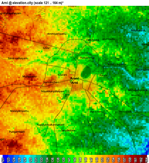
Below is the Elevation map of Arni, which displays elevation range with different colors. Scale of the first map is from 121 to 164 m (397 to 538 ft) with average elevation of 143.6 meters (=471 ft) [note 1]
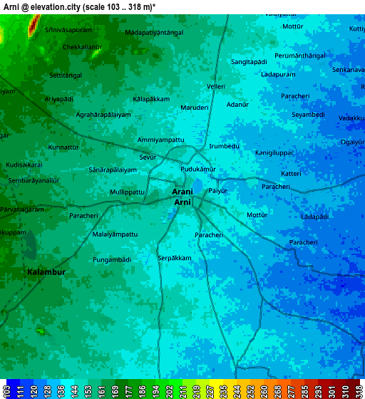
These maps also provides idea of topography and contour of this city, they are displayed at different zoom levels. More info about maps, scale and edge coordinates you can find below images.
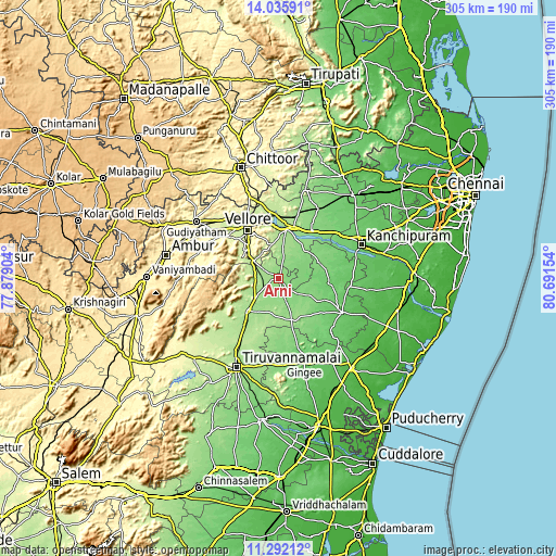
| \ | Map #1 | Map #2 | Topo.Map |
| Scale [m] | 121..164 m | 103..318 m | × |
| Scale [ft] | 397..538 ft | 338..1043 ft | × |
| Average | 143.6 m = 471 ft | 146.5 m = 481 ft | × |
| Width | 9.53 km = 5.9 mi | 19.07 km = 11.8 mi | 305.1 km = 189.6 mi |
| Height | 9.53 km = 5.9 mi | 19.07 km = 11.8 mi | 305.1 km = 189.6 mi |
| ↑Max Latitude | 12.710582° | 12.753447° | 14.03591° |
| Latitude at center | 12.66771° | 12.66771° | 12.66771° |
| ↓Min Latitude | 12.624831° | 12.581944° | 11.29212° |
| ← Min Longitude | 79.241345° | 79.197399° | 77.87904° |
| Longitude center | 79.28529° | 79.28529° | 79.28529° |
| →Max Longitude | 79.329235° | 79.373181° | 80.69154° |
Nearby cities:
Cities around Arni sort by population:
• Vellore elevation 218 m
32.4 km,  329°
329°
• Arcot 173 m
26.7 km,  7°
7°
• Cheyyar 99 m
28 km,  91°
91°
• Vandavāsi 79 m
39.2 km,  117°
117°
• Walajapet 173 m
29.9 km,  17°
17°
• Polūr 176 m
24.6 km,  225°
225°
• Kātpādi 213 m
36.8 km,  335°
335°
• Pudūr 234 m
39.8 km, 337°
• Kalavai 132 m
18.5 km,  52°
52°
• Peranamallūr 130 m
19.4 km, 123°
• Desūr 116 m
33.3 km,  140°
140°
• Dūsi 88 m
44.4 km,  74°
74°
Multilingual:
 En español:
Arni elevación 149 m.
 En France:
Arni élévation 149 m.


Sources and notes:
- [note 1] Map square and city borders are not equal. Map elevation data is calculated only from area inside that square.
- [src 1] Elevation data from geonames database provided with same terms of usage.
- [src 2] The elevation map of Arni is generated using elevation data from NASA's 3 arcsec (90m) resolution SRTM data.
- [src 3] Base (background) map © OpenStreetMap contributors tiles are generated by Geofabrik and OpenTopoMap.
Copyright & License:
This Arni Elevation Map is licensed under CC BY-SA. You may reuse any part from this page, if you give a proper credit by linking to this URL:
 More info on terms of use page.