Awantipur elevation
Awantipur (Jammu and Kashmir, Pulwama), India elevation is 1601 meters and Awantipur elevation in feet is 5253 ft above sea level [src 1]. Awantipur is a populated place (feature code) with elevation that is 1308 meters (4291 ft) bigger than average city elevation in India.
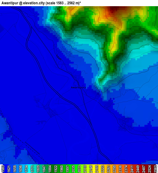
Below is the Elevation map of Awantipur, which displays elevation range with different colors. Scale of the first map is from 1583 to 2562 m (5194 to 8406 ft) with average elevation of 1685.9 meters (=5531 ft) [note 1]
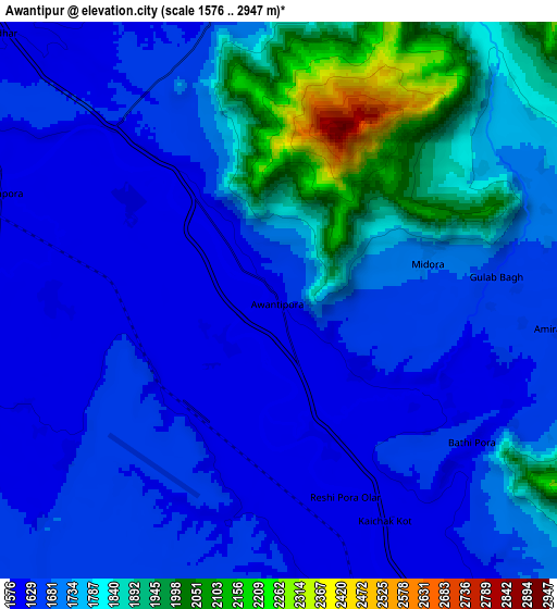
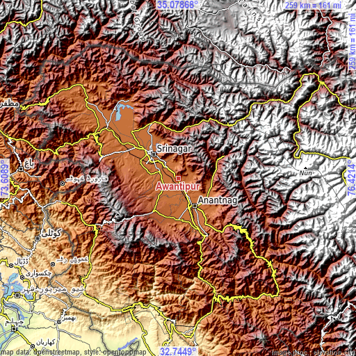
These maps also provides idea of topography and contour of this city, they are displayed at different zoom levels. More info about maps, scale and edge coordinates you can find below images.
| \ | Map #1 | Map #2 | Topo.Map |
| Scale [m] | 1583..2562 m | 1576..2947 m | × |
| Scale [ft] | 5194..8406 ft | 5171..9669 ft | × |
| Average | 1685.9 m = 5531 ft | 1724.5 m = 5658 ft | × |
| Width | 8.11 km = 5 mi | 16.22 km = 10.1 mi | 259.5 km = 161.2 mi |
| Height | 8.11 km = 5 mi | 16.22 km = 10.1 mi | 259.5 km = 161.2 mi |
| ↑Max Latitude | 33.956239° | 33.992682° | 35.07868° |
| Latitude at center | 33.91978° | 33.91978° | 33.91978° |
| ↓Min Latitude | 33.883306° | 33.846815° | 32.7449° |
| ← Min Longitude | 74.971205° | 74.927259° | 73.6089° |
| Longitude center | 75.01515° | 75.01515° | 75.01515° |
| →Max Longitude | 75.059095° | 75.103041° | 76.4214° |
Nearby cities:
Cities around Awantipur sort by population:
• Srinagar elevation 1589 m
26.7 km,  313°
313°
• Soyībug 1587 m
33.4 km,  301°
301°
• Anantnag 1606 m
24.6 km,  148°
148°
• Bijbehara 1607 m
16.4 km, 148°
• Pulwama 1648 m
11.8 km,  244°
244°
• Gāndarbal 1593 m
40.6 km,  326°
326°
• Kulgam 1742 m
30.6 km,  179°
179°
• Shupīyan 2055 m
28.1 km,  216°
216°
• Trāl 1713 m
9.3 km,  85°
85°
• Tsrār Sharīf 1953 m
23.9 km,  254°
254°
• Pahlgām 2155 m
30 km,  69°
69°
• Qāzigund 1666 m
33.4 km,  159°
159°
Multilingual:
 En español:
Awantipur elevación 1601 m.
 En France:
Awantipur élévation 1601 m.
 Auf Deutsch:
Awantipur höhe über dem Meeresspiegel ist 1601 m.

Sources and notes:
- [note 1] Map square and city borders are not equal. Map elevation data is calculated only from area inside that square.
- [src 1] Elevation data from geonames database provided with same terms of usage.
- [src 2] The elevation map of Awantipur is generated using elevation data from NASA's 3 arcsec (90m) resolution SRTM data.
- [src 3] Base (background) map © OpenStreetMap contributors tiles are generated by Geofabrik and OpenTopoMap.
Copyright & License:
This Awantipur Elevation Map is licensed under CC BY-SA. You may reuse any part from this page, if you give a proper credit by linking to this URL:
 More info on terms of use page.