Bāg elevation
Bāg (Madhya Pradesh, Dhār), India elevation is 238 meters and Bāg elevation in feet is 781 ft above sea level [src 1]. Bāg is a populated place (feature code) with elevation that is 55 meters (180 ft) smaller than average city elevation in India.
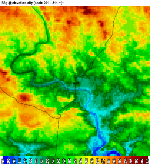
Below is the Elevation map of Bāg, which displays elevation range with different colors. Scale of the first map is from 201 to 311 m (659 to 1020 ft) with average elevation of 255.3 meters (=838 ft) [note 1]
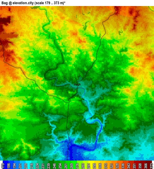
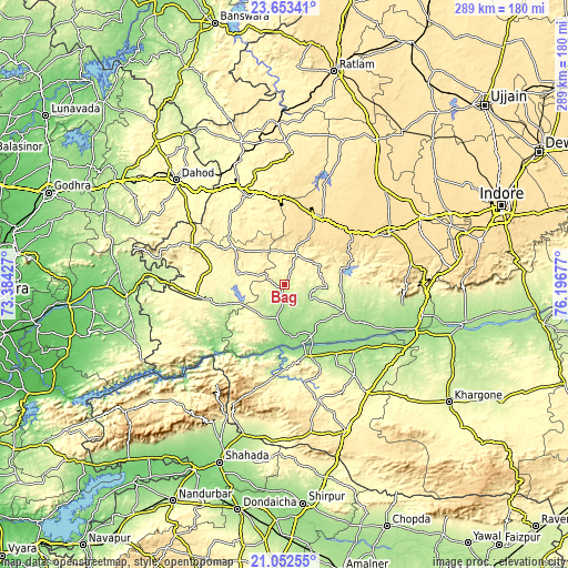
These maps also provides idea of topography and contour of this city, they are displayed at different zoom levels. More info about maps, scale and edge coordinates you can find below images.
| \ | Map #1 | Map #2 | Topo.Map |
| Scale [m] | 201..311 m | 179..373 m | × |
| Scale [ft] | 659..1020 ft | 587..1224 ft | × |
| Average | 255.3 m = 838 ft | 269.5 m = 884 ft | × |
| Width | 9.04 km = 5.6 mi | 18.08 km = 11.2 mi | 289.2 km = 179.7 mi |
| Height | 9.04 km = 5.6 mi | 18.08 km = 11.2 mi | 289.2 km = 179.7 mi |
| ↑Max Latitude | 22.399685° | 22.440309° | 23.65341° |
| Latitude at center | 22.35905° | 22.35905° | 22.35905° |
| ↓Min Latitude | 22.318403° | 22.277743° | 21.05255° |
| ← Min Longitude | 74.746575° | 74.702629° | 73.38427° |
| Longitude center | 74.79052° | 74.79052° | 74.79052° |
| →Max Longitude | 74.834465° | 74.878411° | 76.19677° |
Nearby cities:
Cities around Bāg sort by population:
• Dhār elevation 559 m
58.3 km,  63°
63°
• Barwāni 182 m
38 km,  162°
162°
• Jhābua 334 m
49.8 km,  335°
335°
• Manāwar 195 m
33.6 km,  114°
114°
• Rajpur 288 m
45.1 km,  262°
262°
• Kukshi 176 m
17.3 km,  191°
191°
• Anjad 165 m
44.6 km,  142°
142°
• Rajpur 231 m
58.6 km, 142°
• Rājgarh 518 m
38.9 km,  24°
24°
• Jobat 305 m
23.7 km,  285°
285°
• Rānāpur 377 m
42.3 km,  319°
319°
• Bhābhra 369 m
51.2 km, 291°
Multilingual:
 En español:
Bāg elevación 238 m.
 En France:
Bāg élévation 238 m.


Sources and notes:
- [note 1] Map square and city borders are not equal. Map elevation data is calculated only from area inside that square.
- [src 1] Elevation data from geonames database provided with same terms of usage.
- [src 2] The elevation map of Bāg is generated using elevation data from NASA's 3 arcsec (90m) resolution SRTM data.
- [src 3] Base (background) map © OpenStreetMap contributors tiles are generated by Geofabrik and OpenTopoMap.
Copyright & License:
This Bāg Elevation Map is licensed under CC BY-SA. You may reuse any part from this page, if you give a proper credit by linking to this URL:
 More info on terms of use page.