Bahua elevation
Bahua (Uttar Pradesh, Fatehpur), India elevation is 123 meters and Bahua elevation in feet is 404 ft above sea level [src 1]. Bahua is a populated place (feature code) with elevation that is 170 meters (558 ft) smaller than average city elevation in India.
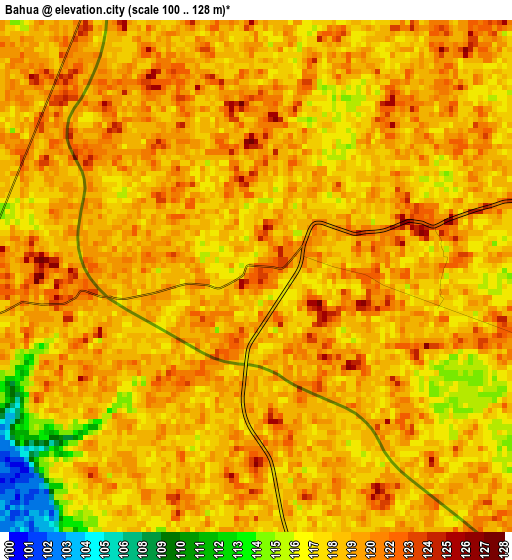
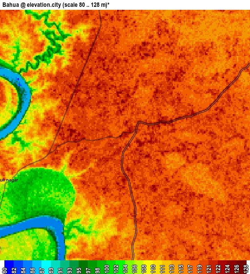
Below is the Elevation map of Bahua, which displays elevation range with different colors. Scale of the first map is from 100 to 128 m (328 to 420 ft) with average elevation of 118.8 meters (=390 ft) [note 1]
These maps also provides idea of topography and contour of this city, they are displayed at different zoom levels. More info about maps, scale and edge coordinates you can find below images.
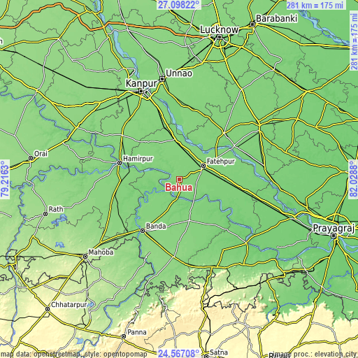
| \ | Map #1 | Map #2 | Topo.Map |
| Scale [m] | 100..128 m | 80..128 m | × |
| Scale [ft] | 328..420 ft | 262..420 ft | × |
| Average | 118.8 m = 390 ft | 114.8 m = 377 ft | × |
| Width | 8.8 km = 5.5 mi | 17.59 km = 10.9 mi | 281.4 km = 174.9 mi |
| Height | 8.8 km = 5.5 mi | 17.59 km = 10.9 mi | 281.4 km = 174.9 mi |
| ↑Max Latitude | 25.878965° | 25.918497° | 27.09822° |
| Latitude at center | 25.83942° | 25.83942° | 25.83942° |
| ↓Min Latitude | 25.799862° | 25.76029° | 24.56708° |
| ← Min Longitude | 80.578605° | 80.534659° | 79.2163° |
| Longitude center | 80.62255° | 80.62255° | 80.62255° |
| →Max Longitude | 80.666495° | 80.710441° | 82.0288° |
Nearby cities:
Cities around Bahua sort by population:
• Fatehpur elevation 121 m
21.4 km,  62°
62°
• Bānda 127 m
49.5 km,  215°
215°
• Bindki 125 m
22.4 km,  348°
348°
• Hamīrpur 115 m
49.1 km,  285°
285°
• Baberu 129 m
33.5 km,  165°
165°
• Khāga 115 m
48.8 km,  98°
98°
• Dalmau 108 m
47.8 km, 58°
• Bisenda Buzurg 134 m
48.5 km,  180°
180°
• Tindwāri 121 m
26.5 km,  201°
201°
• Bhagwantnagar 127 m
44.8 km,  17°
17°
• Oran 133 m
53.7 km, 167°
• Kishanpur 109 m
45.7 km,  118°
118°
Multilingual:
 En español:
Bahua elevación 123 m.
 En France:
Bahua élévation 123 m.


Sources and notes:
- [note 1] Map square and city borders are not equal. Map elevation data is calculated only from area inside that square.
- [src 1] Elevation data from geonames database provided with same terms of usage.
- [src 2] The elevation map of Bahua is generated using elevation data from NASA's 3 arcsec (90m) resolution SRTM data.
- [src 3] Base (background) map © OpenStreetMap contributors tiles are generated by Geofabrik and OpenTopoMap.
Copyright & License:
This Bahua Elevation Map is licensed under CC BY-SA. You may reuse any part from this page, if you give a proper credit by linking to this URL:
 More info on terms of use page.