Bīlāspur elevation
Bīlāspur (Uttar Pradesh, Rāmpur), India elevation is 199 meters and Bīlāspur elevation in feet is 653 ft above sea level [src 1]. Bīlāspur is a populated place (feature code) with elevation that is 94 meters (308 ft) smaller than average city elevation in India.
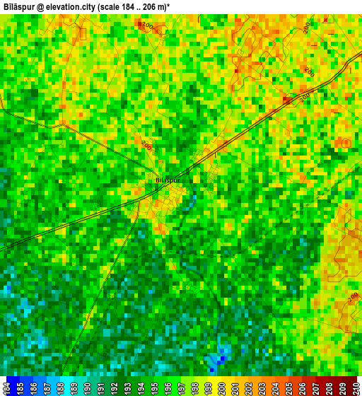
Below is the Elevation map of Bīlāspur, which displays elevation range with different colors. Scale of the first map is from 184 to 206 m (604 to 676 ft) with average elevation of 195.6 meters (=642 ft) [note 1]
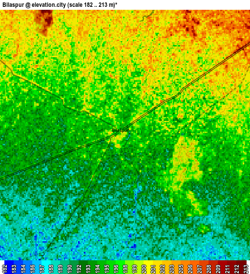
These maps also provides idea of topography and contour of this city, they are displayed at different zoom levels. More info about maps, scale and edge coordinates you can find below images.
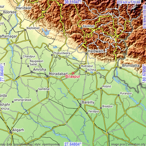
| \ | Map #1 | Map #2 | Topo.Map |
| Scale [m] | 184..206 m | 182..213 m | × |
| Scale [ft] | 604..676 ft | 597..699 ft | × |
| Average | 195.6 m = 642 ft | 195.5 m = 641 ft | × |
| Width | 8.56 km = 5.3 mi | 17.11 km = 10.6 mi | 273.8 km = 170.1 mi |
| Height | 8.56 km = 5.3 mi | 17.11 km = 10.6 mi | 273.8 km = 170.1 mi |
| ↑Max Latitude | 28.92502° | 28.963477° | 30.11047° |
| Latitude at center | 28.88655° | 28.88655° | 28.88655° |
| ↓Min Latitude | 28.848065° | 28.809566° | 27.64804° |
| ← Min Longitude | 79.226355° | 79.182409° | 77.86405° |
| Longitude center | 79.2703° | 79.2703° | 79.2703° |
| →Max Longitude | 79.314245° | 79.358191° | 80.67655° |
Nearby cities:
Cities around Bīlāspur sort by population:
• Rāmpur elevation 196 m
25.2 km,  250°
250°
• Baheri 194 m
25.4 km,  119°
119°
• Tānda 208 m
33.5 km,  287°
287°
• Kichha 208 m
24.5 km,  83°
83°
• Suār 211 m
26.1 km,  307°
307°
• Milak 184 m
32.2 km,  197°
197°
• Kemrī 188 m
10.9 km,  215°
215°
• Bāzpur 227 m
33.6 km,  331°
331°
• Shīshgarh 185 m
18 km,  166°
166°
• Deoraniān 189 m
34.9 km,  144°
144°
• Richha 187 m
32.6 km,  130°
130°
• Shergarh 184 m
27.8 km,  159°
159°
Multilingual:
 En español:
Bīlāspur elevación 199 m.
 En France:
Bīlāspur élévation 199 m.
 Auf Deutsch:
Bīlāspur höhe über dem Meeresspiegel ist 199 m.

Sources and notes:
- [note 1] Map square and city borders are not equal. Map elevation data is calculated only from area inside that square.
- [src 1] Elevation data from geonames database provided with same terms of usage.
- [src 2] The elevation map of Bīlāspur is generated using elevation data from NASA's 3 arcsec (90m) resolution SRTM data.
- [src 3] Base (background) map © OpenStreetMap contributors tiles are generated by Geofabrik and OpenTopoMap.
Copyright & License:
This Bīlāspur Elevation Map is licensed under CC BY-SA. You may reuse any part from this page, if you give a proper credit by linking to this URL:
 More info on terms of use page.