Charthāwal elevation
Charthāwal (Uttar Pradesh, Muzaffarnagar), India elevation is 256 meters and Charthāwal elevation in feet is 840 ft above sea level [src 1]. Charthāwal is a populated place (feature code) with elevation that is 37 meters (121 ft) smaller than average city elevation in India.
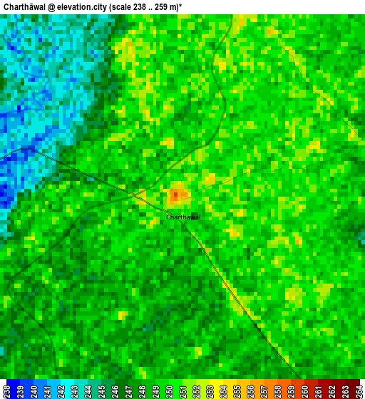
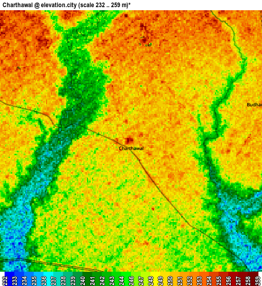
Below is the Elevation map of Charthāwal, which displays elevation range with different colors. Scale of the first map is from 238 to 259 m (781 to 850 ft) with average elevation of 248.2 meters (=814 ft) [note 1]
These maps also provides idea of topography and contour of this city, they are displayed at different zoom levels. More info about maps, scale and edge coordinates you can find below images.
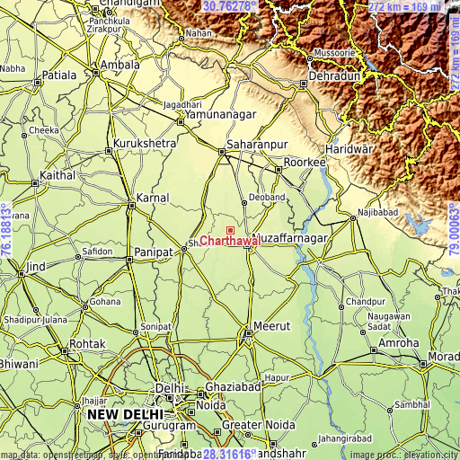
| \ | Map #1 | Map #2 | Topo.Map |
| Scale [m] | 238..259 m | 232..259 m | × |
| Scale [ft] | 781..850 ft | 761..850 ft | × |
| Average | 248.2 m = 814 ft | 247.4 m = 812 ft | × |
| Width | 8.5 km = 5.3 mi | 17 km = 10.6 mi | 272 km = 169 mi |
| Height | 8.5 km = 5.3 mi | 17 km = 10.6 mi | 272 km = 169 mi |
| ↑Max Latitude | 29.585093° | 29.623302° | 30.76278° |
| Latitude at center | 29.54687° | 29.54687° | 29.54687° |
| ↓Min Latitude | 29.508632° | 29.47038° | 28.31616° |
| ← Min Longitude | 77.550435° | 77.506489° | 76.18813° |
| Longitude center | 77.59438° | 77.59438° | 77.59438° |
| →Max Longitude | 77.638325° | 77.682271° | 79.00063° |
Nearby cities:
Cities around Charthāwal sort by population:
• Muzaffarnagar elevation 251 m
13.5 km,  128°
128°
• Shāmli 248 m
29.6 km,  248°
248°
• Deoband 263 m
18.4 km,  26°
26°
• Budhāna 240 m
31 km,  201°
201°
• Thāna Bhawan 253 m
17.6 km,  284°
284°
• Jalālābad 258 m
17 km,  297°
297°
• Banat 246 m
25 km, 248°
• Shāhpur 244 m
22.3 km,  190°
190°
• Nanauta 267 m
25.1 km,  317°
317°
• Sisauli 243 m
19.1 km,  219°
219°
• Garhi Pūkhta 252 m
27.6 km,  270°
270°
• Titron 259 m
29.4 km, 297°
Multilingual:
 En español:
Charthāwal elevación 256 m.
 En France:
Charthāwal élévation 256 m.
 Auf Deutsch:
Charthāwal höhe über dem Meeresspiegel ist 256 m.

Sources and notes:
- [note 1] Map square and city borders are not equal. Map elevation data is calculated only from area inside that square.
- [src 1] Elevation data from geonames database provided with same terms of usage.
- [src 2] The elevation map of Charthāwal is generated using elevation data from NASA's 3 arcsec (90m) resolution SRTM data.
- [src 3] Base (background) map © OpenStreetMap contributors tiles are generated by Geofabrik and OpenTopoMap.
Copyright & License:
This Charthāwal Elevation Map is licensed under CC BY-SA. You may reuse any part from this page, if you give a proper credit by linking to this URL:
 More info on terms of use page.