Chēlakara elevation
Chēlakara (Kerala, Thrissur District), India elevation is 44 meters and Chēlakara elevation in feet is 144 ft above sea level [src 1]. Chēlakara is a populated place (feature code) with elevation that is 249 meters (817 ft) smaller than average city elevation in India.
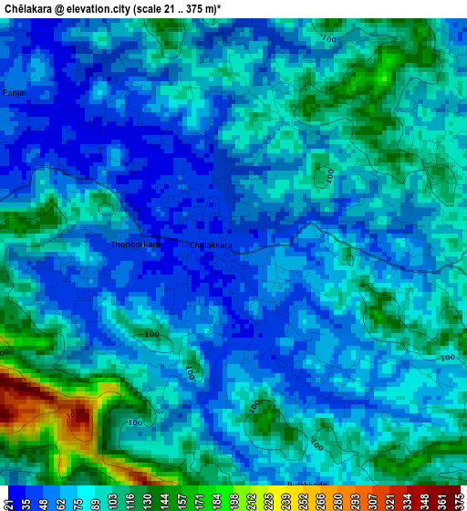
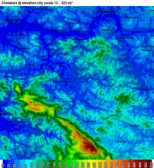
Below is the Elevation map of Chēlakara, which displays elevation range with different colors. Scale of the first map is from 21 to 375 m (69 to 1230 ft) with average elevation of 81.7 meters (=268 ft) [note 1]
These maps also provides idea of topography and contour of this city, they are displayed at different zoom levels. More info about maps, scale and edge coordinates you can find below images.
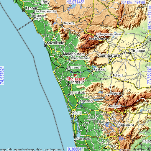
| \ | Map #1 | Map #2 | Topo.Map |
| Scale [m] | 21..375 m | 13..523 m | × |
| Scale [ft] | 69..1230 ft | 43..1716 ft | × |
| Average | 81.7 m = 268 ft | 85.5 m = 281 ft | × |
| Width | 9.6 km = 6 mi | 19.21 km = 11.9 mi | 307.3 km = 190.9 mi |
| Height | 9.6 km = 6 mi | 19.21 km = 11.9 mi | 307.3 km = 190.9 mi |
| ↑Max Latitude | 10.736069° | 10.779242° | 12.07145° |
| Latitude at center | 10.69289° | 10.69289° | 10.69289° |
| ↓Min Latitude | 10.649705° | 10.606513° | 9.30804° |
| ← Min Longitude | 76.299925° | 76.255979° | 74.93762° |
| Longitude center | 76.34387° | 76.34387° | 76.34387° |
| →Max Longitude | 76.387815° | 76.431761° | 77.75012° |
Nearby cities:
Cities around Chēlakara sort by population:
• Thrissur elevation 7 m
24 km,  215°
215°
• Pālghāt 87 m
35 km,  75°
75°
• Kunnamkulam 19 m
30.7 km,  260°
260°
• Mannārakkāt 85 m
35.8 km,  21°
21°
• Ottappālam 44 m
9.7 km, 22°
• Shōranūr 38 m
11.1 km,  313°
313°
• Chetwayi 7 m
37.1 km,  240°
240°
• Cherpulassery 66 m
20.8 km,  349°
349°
• Guruvāyūr 8 m
34.9 km,  251°
251°
• Thanniyam 15 m
38.4 km, 216°
• Avanoor 16 m
20.6 km, 242°
• Edakkulam 16 m
19.8 km, 242°
Multilingual:
 En español:
Chēlakara elevación 44 m.
 En France:
Chēlakara élévation 44 m.
 Auf Deutsch:
Chēlakara höhe über dem Meeresspiegel ist 44 m.

Sources and notes:
- [note 1] Map square and city borders are not equal. Map elevation data is calculated only from area inside that square.
- [src 1] Elevation data from geonames database provided with same terms of usage.
- [src 2] The elevation map of Chēlakara is generated using elevation data from NASA's 3 arcsec (90m) resolution SRTM data.
- [src 3] Base (background) map © OpenStreetMap contributors tiles are generated by Geofabrik and OpenTopoMap.
Copyright & License:
This Chēlakara Elevation Map is licensed under CC BY-SA. You may reuse any part from this page, if you give a proper credit by linking to this URL:
 More info on terms of use page.