Chharra elevation
Chharra (Uttar Pradesh, Alīgarh), India elevation is 182 meters and Chharra elevation in feet is 597 ft above sea level [src 1]. Chharra is a populated place (feature code) with elevation that is 111 meters (364 ft) smaller than average city elevation in India.
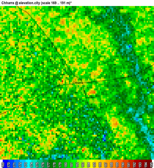
Below is the Elevation map of Chharra, which displays elevation range with different colors. Scale of the first map is from 169 to 191 m (554 to 627 ft) with average elevation of 180.1 meters (=591 ft) [note 1]
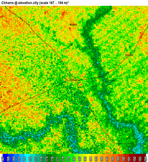
These maps also provides idea of topography and contour of this city, they are displayed at different zoom levels. More info about maps, scale and edge coordinates you can find below images.
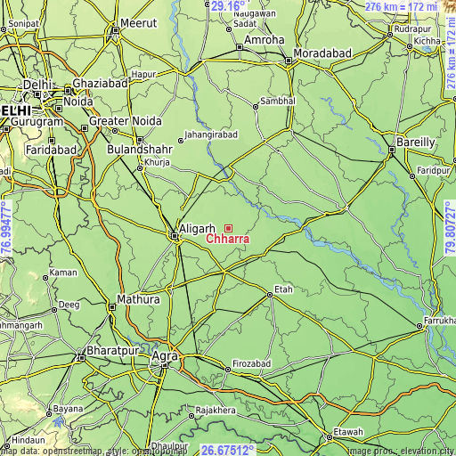
| \ | Map #1 | Map #2 | Topo.Map |
| Scale [m] | 169..191 m | 167..194 m | × |
| Scale [ft] | 554..627 ft | 548..636 ft | × |
| Average | 180.1 m = 591 ft | 180.8 m = 593 ft | × |
| Width | 8.63 km = 5.4 mi | 17.27 km = 10.7 mi | 276.3 km = 171.7 mi |
| Height | 8.63 km = 5.4 mi | 17.27 km = 10.7 mi | 276.3 km = 171.7 mi |
| ↑Max Latitude | 27.963522° | 28.002329° | 29.16° |
| Latitude at center | 27.9247° | 27.9247° | 27.9247° |
| ↓Min Latitude | 27.885865° | 27.847015° | 26.67512° |
| ← Min Longitude | 78.357075° | 78.313129° | 76.99477° |
| Longitude center | 78.40102° | 78.40102° | 78.40102° |
| →Max Longitude | 78.444965° | 78.488911° | 79.80727° |
Nearby cities:
Cities around Chharra sort by population:
• Alīgarh elevation 189 m
32.4 km,  261°
261°
• Kāsganj 181 m
27.3 km,  118°
118°
• Atraulī 194 m
16.3 km,  315°
315°
• Sikandra Rao 186 m
26.3 km,  184°
184°
• Dibai 199 m
34.4 km,  336°
336°
• Soron 177 m
34.1 km,  96°
96°
• Naraura 182 m
30.8 km,  357°
357°
• Gunnaur 182 m
35.3 km,  6°
6°
• Mārahra 181 m
26.6 km,  141°
141°
• Jalālī 190 m
15.9 km,  246°
246°
• Babrāla 184 m
37.8 km,  0°
0°
• Harduāganj 189 m
24 km,  275°
275°
Multilingual:
 En español:
Chharra elevación 182 m.
 En France:
Chharra élévation 182 m.


Sources and notes:
- [note 1] Map square and city borders are not equal. Map elevation data is calculated only from area inside that square.
- [src 1] Elevation data from geonames database provided with same terms of usage.
- [src 2] The elevation map of Chharra is generated using elevation data from NASA's 3 arcsec (90m) resolution SRTM data.
- [src 3] Base (background) map © OpenStreetMap contributors tiles are generated by Geofabrik and OpenTopoMap.
Copyright & License:
This Chharra Elevation Map is licensed under CC BY-SA. You may reuse any part from this page, if you give a proper credit by linking to this URL:
 More info on terms of use page.