Chitradurga elevation
Chitradurga (Karnataka), India elevation is 747 meters and Chitradurga elevation in feet is 2451 ft above sea level [src 1]. Chitradurga is a populated place (feature code) with elevation that is 454 meters (1490 ft) bigger than average city elevation in India.
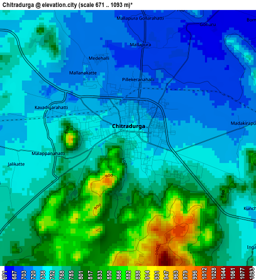
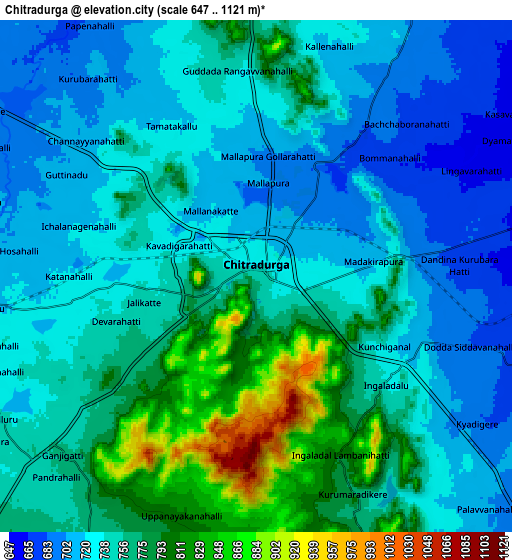
Below is the Elevation map of Chitradurga, which displays elevation range with different colors. Scale of the first map is from 671 to 1093 m (2201 to 3586 ft) with average elevation of 764.7 meters (=2509 ft) [note 1]
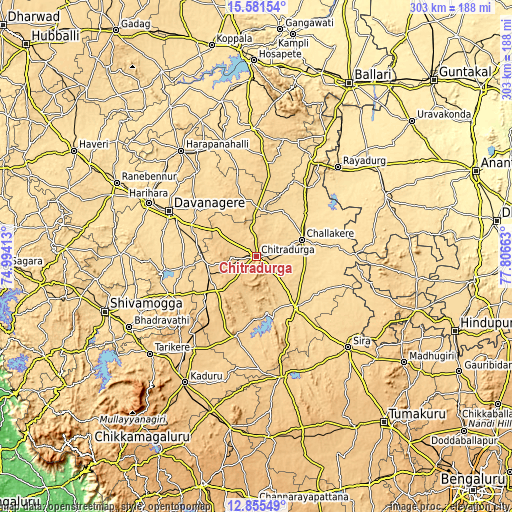
These maps also provides idea of topography and contour of this city, they are displayed at different zoom levels. More info about maps, scale and edge coordinates you can find below images.
| \ | Map #1 | Map #2 | Topo.Map |
| Scale [m] | 671..1093 m | 647..1121 m | × |
| Scale [ft] | 2201..3586 ft | 2123..3678 ft | × |
| Average | 764.7 m = 2509 ft | 749.5 m = 2459 ft | × |
| Width | 9.47 km = 5.9 mi | 18.95 km = 11.8 mi | 303.1 km = 188.3 mi |
| Height | 9.47 km = 5.9 mi | 18.95 km = 11.8 mi | 303.1 km = 188.3 mi |
| ↑Max Latitude | 14.265214° | 14.307801° | 15.58154° |
| Latitude at center | 14.22262° | 14.22262° | 14.22262° |
| ↓Min Latitude | 14.180018° | 14.137407° | 12.85549° |
| ← Min Longitude | 76.356435° | 76.312489° | 74.99413° |
| Longitude center | 76.40038° | 76.40038° | 76.40038° |
| →Max Longitude | 76.444325° | 76.488271° | 77.80663° |
Nearby cities:
Cities around Chitradurga sort by population:
• Davangere elevation 592 m
57.8 km,  298°
298°
• Harihar 546 m
71.6 km, 296°
• Rāyadrug 553 m
72 km,  42°
42°
• Hiriyūr 607 m
38.8 km,  142°
142°
• Challakere 586 m
29.1 km,  68°
68°
• Hosdurga 729 m
49 km,  194°
194°
• Kottūru 585 m
69.7 km,  343°
343°
• Channagiri 691 m
55.7 km,  246°
246°
• Jagalūr 678 m
33.7 km,  348°
348°
• Holalkere 707 m
30.6 km,  229°
229°
• Ajjampur 756 m
69.5 km,  217°
217°
• Māyakonda 648 m
35 km,  282°
282°
Multilingual:
 En español:
Chitradurga elevación 747 m.
 En France:
Chitradurga élévation 747 m.
 Auf Deutsch:
Chitradurga höhe über dem Meeresspiegel ist 747 m.

Sources and notes:
- [note 1] Map square and city borders are not equal. Map elevation data is calculated only from area inside that square.
- [src 1] Elevation data from geonames database provided with same terms of usage.
- [src 2] The elevation map of Chitradurga is generated using elevation data from NASA's 3 arcsec (90m) resolution SRTM data.
- [src 3] Base (background) map © OpenStreetMap contributors tiles are generated by Geofabrik and OpenTopoMap.
Copyright & License:
This Chitradurga Elevation Map is licensed under CC BY-SA. You may reuse any part from this page, if you give a proper credit by linking to this URL:
 More info on terms of use page.