Damoh elevation
Damoh (Madhya Pradesh), India elevation is 378 meters and Damoh elevation in feet is 1240 ft above sea level [src 1]. Damoh is a populated place (feature code) with elevation that is 85 meters (279 ft) bigger than average city elevation in India.
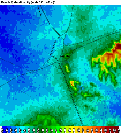
Below is the Elevation map of Damoh, which displays elevation range with different colors. Scale of the first map is from 350 to 461 m (1148 to 1512 ft) with average elevation of 371.3 meters (=1218 ft) [note 1]
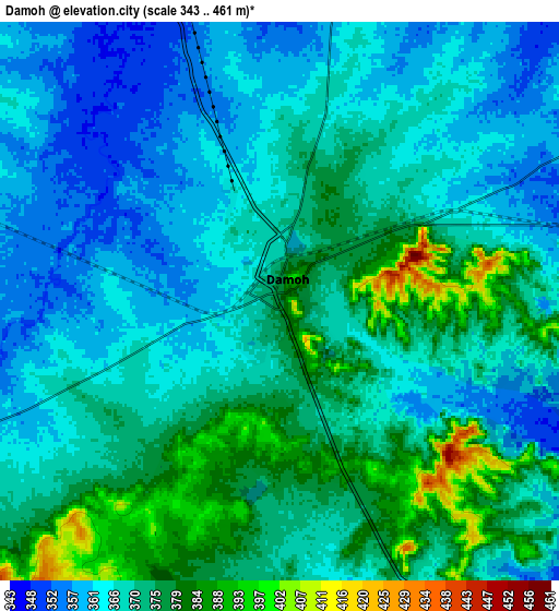
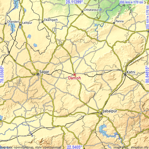
These maps also provides idea of topography and contour of this city, they are displayed at different zoom levels. More info about maps, scale and edge coordinates you can find below images.
| \ | Map #1 | Map #2 | Topo.Map |
| Scale [m] | 350..461 m | 343..461 m | × |
| Scale [ft] | 1148..1512 ft | 1125..1512 ft | × |
| Average | 371.3 m = 1218 ft | 369.4 m = 1212 ft | × |
| Width | 8.94 km = 5.6 mi | 17.88 km = 11.1 mi | 286 km = 177.7 mi |
| Height | 8.94 km = 5.6 mi | 17.88 km = 11.1 mi | 286 km = 177.7 mi |
| ↑Max Latitude | 23.873312° | 23.913491° | 25.11299° |
| Latitude at center | 23.83312° | 23.83312° | 23.83312° |
| ↓Min Latitude | 23.792916° | 23.752699° | 22.5405° |
| ← Min Longitude | 79.397955° | 79.354009° | 78.03565° |
| Longitude center | 79.4419° | 79.4419° | 79.4419° |
| →Max Longitude | 79.485845° | 79.529791° | 80.84815° |
Nearby cities:
Cities around Damoh sort by population:
• Hatta elevation 336 m
37.2 km,  25°
25°
• Banda 475 m
54.3 km,  295°
295°
• Garhākota 391 m
31 km,  258°
258°
• Rehli 406 m
44.3 km,  240°
240°
• Kaimori 374 m
58.6 km,  148°
148°
• Patharia 377 m
26.3 km,  286°
286°
• Katangi 373 m
56.6 km,  140°
140°
• Hindoria 370 m
15.1 km,  58°
58°
• Shāhpur 418 m
40.3 km,  279°
279°
• Tendūkheda 398 m
49.6 km,  168°
168°
• Dhāna 519 m
59.7 km, 260°
• Bakshwāho 499 m
49.1 km,  341°
341°
Multilingual:
 En español:
Damoh elevación 378 m.
 En France:
Damoh élévation 378 m.


Sources and notes:
- [note 1] Map square and city borders are not equal. Map elevation data is calculated only from area inside that square.
- [src 1] Elevation data from geonames database provided with same terms of usage.
- [src 2] The elevation map of Damoh is generated using elevation data from NASA's 3 arcsec (90m) resolution SRTM data.
- [src 3] Base (background) map © OpenStreetMap contributors tiles are generated by Geofabrik and OpenTopoMap.
Copyright & License:
This Damoh Elevation Map is licensed under CC BY-SA. You may reuse any part from this page, if you give a proper credit by linking to this URL:
 More info on terms of use page.