Deūlgaon Rāja elevation
Deūlgaon Rāja (Maharashtra, Buldana), India elevation is 568 meters and Deūlgaon Rāja elevation in feet is 1864 ft above sea level [src 1]. Deūlgaon Rāja is a populated place (feature code) with elevation that is 275 meters (902 ft) bigger than average city elevation in India.
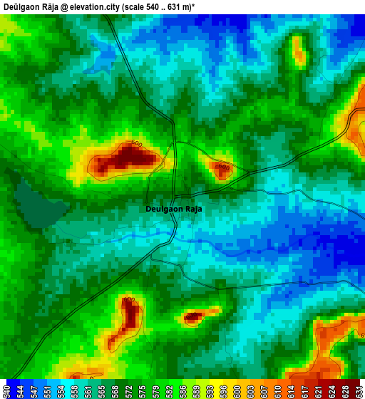
Below is the Elevation map of Deūlgaon Rāja, which displays elevation range with different colors. Scale of the first map is from 540 to 631 m (1772 to 2070 ft) with average elevation of 569.2 meters (=1867 ft) [note 1]
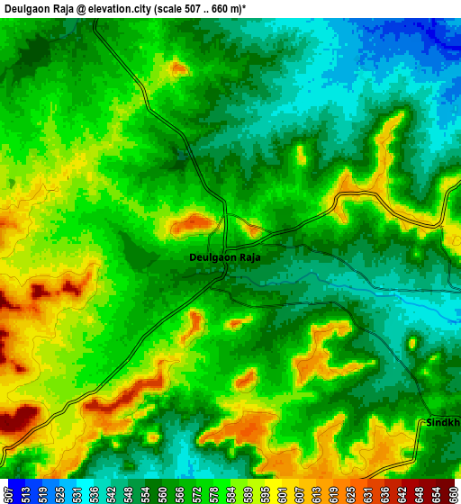
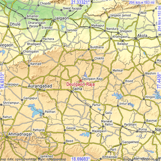
These maps also provides idea of topography and contour of this city, they are displayed at different zoom levels. More info about maps, scale and edge coordinates you can find below images.
| \ | Map #1 | Map #2 | Topo.Map |
| Scale [m] | 540..631 m | 507..660 m | × |
| Scale [ft] | 1772..2070 ft | 1663..2165 ft | × |
| Average | 569.2 m = 1867 ft | 570.3 m = 1871 ft | × |
| Width | 9.18 km = 5.7 mi | 18.36 km = 11.4 mi | 293.8 km = 182.6 mi |
| Height | 9.18 km = 5.7 mi | 18.36 km = 11.4 mi | 293.8 km = 182.6 mi |
| ↑Max Latitude | 20.058855° | 20.100129° | 21.33321° |
| Latitude at center | 20.01757° | 20.01757° | 20.01757° |
| ↓Min Latitude | 19.976274° | 19.934967° | 18.69083° |
| ← Min Longitude | 75.993605° | 75.949659° | 74.6313° |
| Longitude center | 76.03755° | 76.03755° | 76.03755° |
| →Max Longitude | 76.081495° | 76.125441° | 77.4438° |
Nearby cities:
Cities around Deūlgaon Rāja sort by population:
• Aurangabad elevation 588 m
74.3 km,  257°
257°
• Jālna 504 m
25.2 km,  218°
218°
• Buldāna 654 m
58.9 km,  15°
15°
• Chikhli 601 m
43.6 km,  31°
31°
• Sillod 616 m
51.2 km,  308°
308°
• Selu 424 m
75.4 km,  145°
145°
• Mehekar 559 m
57.4 km,  75°
75°
• Partūr 453 m
50.1 km,  158°
158°
• Ambad 512 m
52 km,  210°
210°
• Pīpri 536 m
58.1 km,  244°
244°
• Lonār 604 m
50.6 km,  94°
94°
• Ashti 441 m
73.9 km, 164°
Multilingual:
 En español:
Deūlgaon Rāja elevación 568 m.
 En France:
Deūlgaon Rāja élévation 568 m.
 Auf Deutsch:
Deūlgaon Rāja höhe über dem Meeresspiegel ist 568 m.

Sources and notes:
- [note 1] Map square and city borders are not equal. Map elevation data is calculated only from area inside that square.
- [src 1] Elevation data from geonames database provided with same terms of usage.
- [src 2] The elevation map of Deūlgaon Rāja is generated using elevation data from NASA's 3 arcsec (90m) resolution SRTM data.
- [src 3] Base (background) map © OpenStreetMap contributors tiles are generated by Geofabrik and OpenTopoMap.
Copyright & License:
This Deūlgaon Rāja Elevation Map is licensed under CC BY-SA. You may reuse any part from this page, if you give a proper credit by linking to this URL:
 More info on terms of use page.