Doda elevation
Doda (Jammu and Kashmir), India elevation is 1191 meters and Doda elevation in feet is 3907 ft above sea level [src 1]. Doda is a populated place (feature code) with elevation that is 898 meters (2946 ft) bigger than average city elevation in India.
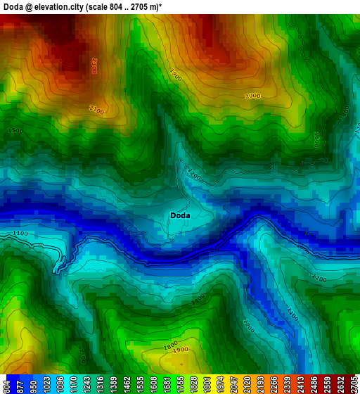
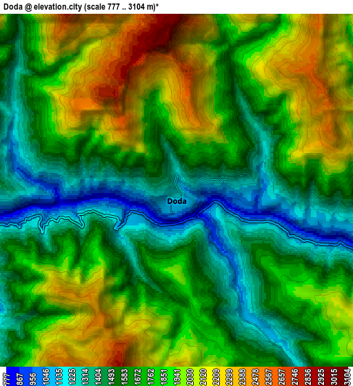
Below is the Elevation map of Doda, which displays elevation range with different colors. Scale of the first map is from 804 to 2705 m (2638 to 8875 ft) with average elevation of 1487.9 meters (=4882 ft) [note 1]
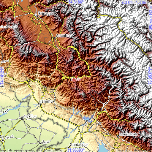
These maps also provides idea of topography and contour of this city, they are displayed at different zoom levels. More info about maps, scale and edge coordinates you can find below images.
| \ | Map #1 | Map #2 | Topo.Map |
| Scale [m] | 804..2705 m | 777..3104 m | × |
| Scale [ft] | 2638..8875 ft | 2549..10184 ft | × |
| Average | 1487.9 m = 4882 ft | 1763.8 m = 5787 ft | × |
| Width | 8.18 km = 5.1 mi | 16.36 km = 10.2 mi | 261.8 km = 162.7 mi |
| Height | 8.18 km = 5.1 mi | 16.36 km = 10.2 mi | 261.8 km = 162.7 mi |
| ↑Max Latitude | 33.185945° | 33.222716° | 34.3186° |
| Latitude at center | 33.14916° | 33.14916° | 33.14916° |
| ↓Min Latitude | 33.112359° | 33.075543° | 31.96393° |
| ← Min Longitude | 75.503515° | 75.459569° | 74.14121° |
| Longitude center | 75.54746° | 75.54746° | 75.54746° |
| →Max Longitude | 75.591405° | 75.635351° | 76.95371° |
Nearby cities:
Cities around Doda sort by population:
• Udhampur elevation 759 m
45.8 km,  236°
236°
• Kishtwār 1642 m
27.4 km,  48°
48°
• Kulgam 1742 m
73.7 km,  318°
318°
• Bhadarwāh 1636 m
24.6 km,  140°
140°
• Katra 868 m
60 km,  253°
253°
• Rāmnagar 829 m
43.9 km,  210°
210°
• Riāsi 521 m
67 km,  263°
263°
• Rāmban 724 m
30.9 km,  289°
289°
• Qāzigund 1666 m
66.1 km,  325°
325°
• Batoti 1547 m
22.5 km, 261°
• Banihāl 1649 m
45.6 km,  314°
314°
• Kūd 1792 m
25.7 km, 250°
Multilingual:
 En español:
Doda elevación 1191 m.
 En France:
Doda élévation 1191 m.


Sources and notes:
- [note 1] Map square and city borders are not equal. Map elevation data is calculated only from area inside that square.
- [src 1] Elevation data from geonames database provided with same terms of usage.
- [src 2] The elevation map of Doda is generated using elevation data from NASA's 3 arcsec (90m) resolution SRTM data.
- [src 3] Base (background) map © OpenStreetMap contributors tiles are generated by Geofabrik and OpenTopoMap.
Copyright & License:
This Doda Elevation Map is licensed under CC BY-SA. You may reuse any part from this page, if you give a proper credit by linking to this URL:
 More info on terms of use page.