Erāttupetta elevation
Erāttupetta (Kerala, Kottayam), India elevation is 29 meters and Erāttupetta elevation in feet is 95 ft above sea level [src 1]. Erāttupetta is a populated place (feature code) with elevation that is 264 meters (866 ft) smaller than average city elevation in India.
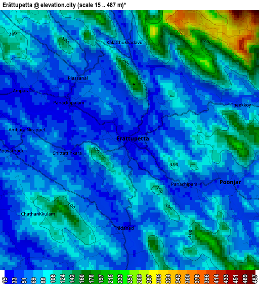
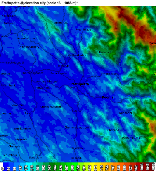
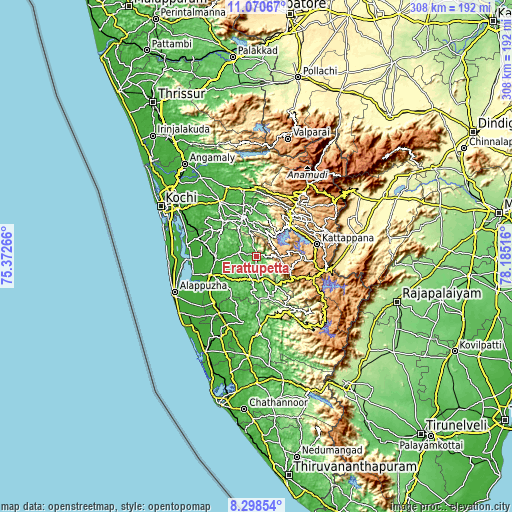
Below is the Elevation map of Erāttupetta, which displays elevation range with different colors. Scale of the first map is from 15 to 487 m (49 to 1598 ft) with average elevation of 87 meters (=285 ft) [note 1]
These maps also provides idea of topography and contour of this city, they are displayed at different zoom levels. More info about maps, scale and edge coordinates you can find below images.
| \ | Map #1 | Map #2 | Topo.Map |
| Scale [m] | 15..487 m | 13..1086 m | × |
| Scale [ft] | 49..1598 ft | 43..3563 ft | × |
| Average | 87 m = 285 ft | 177.4 m = 582 ft | × |
| Width | 9.63 km = 6 mi | 19.27 km = 12 mi | 308.2 km = 191.5 mi |
| Height | 9.63 km = 6 mi | 19.27 km = 12 mi | 308.3 km = 191.6 mi |
| ↑Max Latitude | 9.730786° | 9.774096° | 11.07067° |
| Latitude at center | 9.68747° | 9.68747° | 9.68747° |
| ↓Min Latitude | 9.644149° | 9.600822° | 8.29854° |
| ← Min Longitude | 76.734965° | 76.691019° | 75.37266° |
| Longitude center | 76.77891° | 76.77891° | 76.77891° |
| →Max Longitude | 76.822855° | 76.866801° | 78.18516° |
Nearby cities:
Cities around Erāttupetta sort by population:
• Kottayam elevation 20 m
30.4 km,  248°
248°
• Tiruvalla 14 m
40.7 km,  213°
213°
• Changanācheri 14 m
38.1 km,  224°
224°
• Kotamangalam 26 m
45 km,  338°
338°
• Mūvattupula 28 m
39.8 km,  326°
326°
• Muvattupuzha 41 m
39.5 km, 325°
• Piravam 5 m
36.5 km,  303°
303°
• Vaikam 14 m
42.5 km,  279°
279°
• Idukki 610 m
27.4 km,  48°
48°
• Rāmamangalam 32 m
41 km,  311°
311°
• Lālam 55 m
9.2 km,  290°
290°
• Palackattumala 90 m
17.5 km, 290°
Multilingual:
 En español:
Erāttupetta elevación 29 m.
 En France:
Erāttupetta élévation 29 m.
 Auf Deutsch:
Erāttupetta höhe über dem Meeresspiegel ist 29 m.

Sources and notes:
- [note 1] Map square and city borders are not equal. Map elevation data is calculated only from area inside that square.
- [src 1] Elevation data from geonames database provided with same terms of usage.
- [src 2] The elevation map of Erāttupetta is generated using elevation data from NASA's 3 arcsec (90m) resolution SRTM data.
- [src 3] Base (background) map © OpenStreetMap contributors tiles are generated by Geofabrik and OpenTopoMap.
Copyright & License:
This Erāttupetta Elevation Map is licensed under CC BY-SA. You may reuse any part from this page, if you give a proper credit by linking to this URL:
 More info on terms of use page.