Fatwa elevation
Fatwa (Bihar, Patna), India elevation is 55 meters and Fatwa elevation in feet is 180 ft above sea level [src 1]. Fatwa is a populated place (feature code) with elevation that is 238 meters (781 ft) smaller than average city elevation in India.
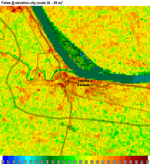
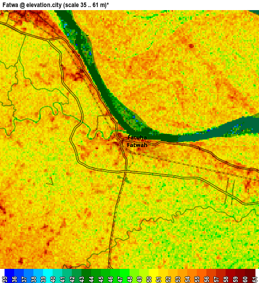
Below is the Elevation map of Fatwa, which displays elevation range with different colors. Scale of the first map is from 36 to 59 m (118 to 194 ft) with average elevation of 50.5 meters (=166 ft) [note 1]
These maps also provides idea of topography and contour of this city, they are displayed at different zoom levels. More info about maps, scale and edge coordinates you can find below images.
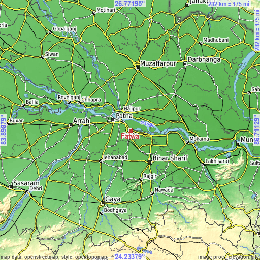
| \ | Map #1 | Map #2 | Topo.Map |
| Scale [m] | 36..59 m | 35..61 m | × |
| Scale [ft] | 118..194 ft | 115..200 ft | × |
| Average | 50.5 m = 166 ft | 50.6 m = 166 ft | × |
| Width | 8.82 km = 5.5 mi | 17.64 km = 11 mi | 282.2 km = 175.4 mi |
| Height | 8.82 km = 5.5 mi | 17.64 km = 11 mi | 282.2 km = 175.4 mi |
| ↑Max Latitude | 25.549235° | 25.588876° | 26.77195° |
| Latitude at center | 25.50958° | 25.50958° | 25.50958° |
| ↓Min Latitude | 25.469912° | 25.430231° | 24.23379° |
| ← Min Longitude | 85.261095° | 85.217149° | 83.89879° |
| Longitude center | 85.30504° | 85.30504° | 85.30504° |
| →Max Longitude | 85.348985° | 85.392931° | 86.71129° |
Nearby cities:
Cities around Fatwa sort by population:
• Patna elevation 53 m
19.4 km,  298°
298°
• Bihār Sharīf 68 m
40.8 km,  147°
147°
• Dinapore 59 m
29.4 km, 298°
• Hājīpur 55 m
21.8 km,  333°
333°
• Masaurhi Buzurg 62 m
32.4 km,  237°
237°
• Khagaul 61 m
27.1 km,  286°
286°
• Bārh 52 m
40.7 km,  94°
94°
• Hilsa 60 m
21.6 km,  186°
186°
• Bakhtiyārpur 55 m
23.4 km,  103°
103°
• Dighwāra 59 m
39.4 km,  311°
311°
• Mohiuddinnagar 55 m
37.2 km,  78°
78°
• Khusropur 56 m
8.6 km,  111°
111°
Multilingual:
 En español:
Fatwa elevación 55 m.
 En France:
Fatwa élévation 55 m.


Sources and notes:
- [note 1] Map square and city borders are not equal. Map elevation data is calculated only from area inside that square.
- [src 1] Elevation data from geonames database provided with same terms of usage.
- [src 2] The elevation map of Fatwa is generated using elevation data from NASA's 3 arcsec (90m) resolution SRTM data.
- [src 3] Base (background) map © OpenStreetMap contributors tiles are generated by Geofabrik and OpenTopoMap.
Copyright & License:
This Fatwa Elevation Map is licensed under CC BY-SA. You may reuse any part from this page, if you give a proper credit by linking to this URL:
 More info on terms of use page.