Goshāinganj elevation
Goshāinganj (Uttar Pradesh, Faizābād), India elevation is 99 meters and Goshāinganj elevation in feet is 325 ft above sea level [src 1]. Goshāinganj is a populated place (feature code) with elevation that is 194 meters (636 ft) smaller than average city elevation in India.
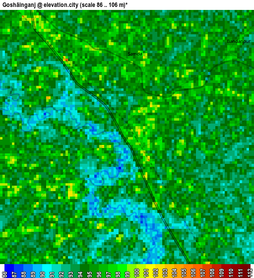
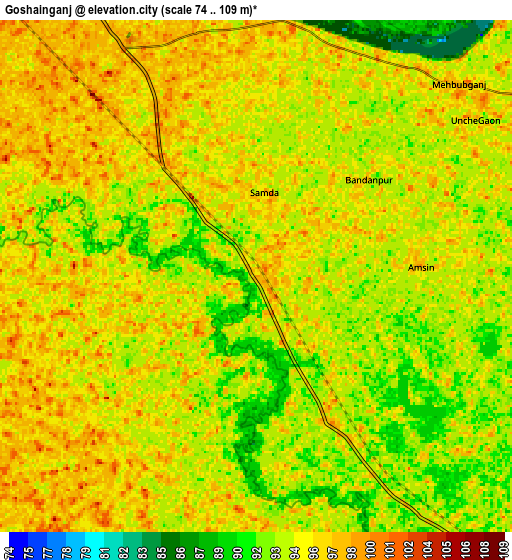
Below is the Elevation map of Goshāinganj, which displays elevation range with different colors. Scale of the first map is from 86 to 106 m (282 to 348 ft) with average elevation of 94.1 meters (=309 ft) [note 1]
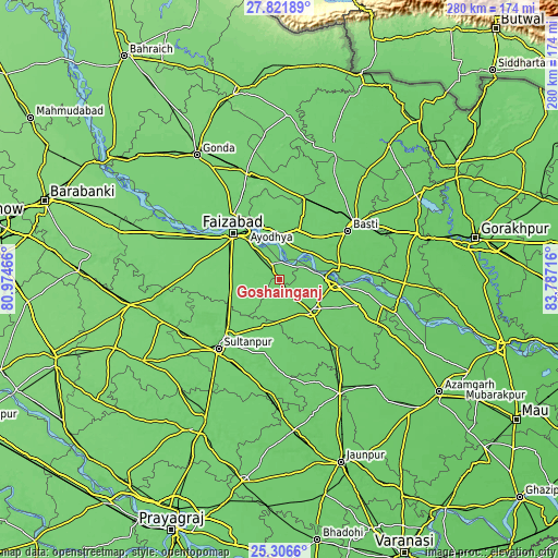
These maps also provides idea of topography and contour of this city, they are displayed at different zoom levels. More info about maps, scale and edge coordinates you can find below images.
| \ | Map #1 | Map #2 | Topo.Map |
| Scale [m] | 86..106 m | 74..109 m | × |
| Scale [ft] | 282..348 ft | 243..358 ft | × |
| Average | 94.1 m = 309 ft | 94.5 m = 310 ft | × |
| Width | 8.74 km = 5.4 mi | 17.48 km = 10.9 mi | 279.7 km = 173.8 mi |
| Height | 8.74 km = 5.4 mi | 17.48 km = 10.9 mi | 279.7 km = 173.8 mi |
| ↑Max Latitude | 26.610447° | 26.649731° | 27.82189° |
| Latitude at center | 26.57115° | 26.57115° | 26.57115° |
| ↓Min Latitude | 26.531839° | 26.492515° | 25.3066° |
| ← Min Longitude | 82.336965° | 82.293019° | 80.97466° |
| Longitude center | 82.38091° | 82.38091° | 82.38091° |
| →Max Longitude | 82.424855° | 82.468801° | 83.78716° |
Nearby cities:
Cities around Goshāinganj sort by population:
• Fyzābād elevation 106 m
32.3 km,  314°
314°
• Bastī 92 m
41.1 km,  54°
54°
• Sultānpur 104 m
46.4 km,  221°
221°
• Tāndā 95 m
27.7 km,  94°
94°
• Ajodhya 102 m
30.8 km,  325°
325°
• Akbarpur 89 m
21.9 km,  135°
135°
• Jalālpur 90 m
45.8 km,  129°
129°
• Nawābganj 100 m
40.3 km,  323°
323°
• Bīkāpur 105 m
24.8 km,  276°
276°
• Dostpur 97 m
34.1 km,  164°
164°
• Haraiya 94 m
26.2 km,  18°
18°
• Kādīpur 93 m
44.9 km,  181°
181°
Multilingual:
 En español:
Goshāinganj elevación 99 m.
 En France:
Goshāinganj élévation 99 m.
 Auf Deutsch:
Goshāinganj höhe über dem Meeresspiegel ist 99 m.

Sources and notes:
- [note 1] Map square and city borders are not equal. Map elevation data is calculated only from area inside that square.
- [src 1] Elevation data from geonames database provided with same terms of usage.
- [src 2] The elevation map of Goshāinganj is generated using elevation data from NASA's 3 arcsec (90m) resolution SRTM data.
- [src 3] Base (background) map © OpenStreetMap contributors tiles are generated by Geofabrik and OpenTopoMap.
Copyright & License:
This Goshāinganj Elevation Map is licensed under CC BY-SA. You may reuse any part from this page, if you give a proper credit by linking to this URL:
 More info on terms of use page.